|

Times are GMT (UTC, Z). Observations at this station [ ] are 24-h 09-09 GMT, some others { } occasionally refer to other 24-h periods, extremes (provisional) maximum, minimum, rainfall and sunshine are usually 21-21 GMT. When averages are referred to (.) compares with the last decade and [.] with the new 30-y climatological average [1981 - 2010]. All data are subject to verification and amendment.
FEBRUARY EVENTS
MARCH EVENTS
APRIL EVENTS
January 2020
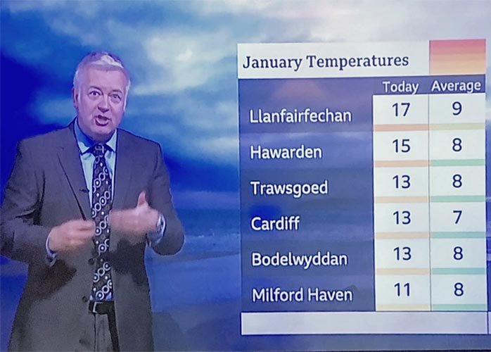
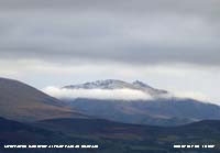
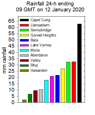
January 1 - a fine sunny morning to start the new year, cool overnight air minimum 2.2C with a touch of ground frost (-1.4C). Air pressure was steady on 1029 mb with high-pressure to the S 1036 mb Spain and 1035 mb SE Europe. Low 971 mb was N of Iceland while a low over Biscay was losing its identity another 970 mb was over the Atlantic to the west. It was sunny along the North Wales coast to N and N E England while SE England had mist and fog. Visibility was good and it was possible to make out the last remnants of a snow patch on Carnedd Llywelyn, otherwise snow was absent from the mountains (Loch Glascarnoch 10.7C Milford Haven 9.2C Redesdale Camp -6.7C Plymouth 3.0 mm Leeming 5.3h Hawarden 5.1h) [Max 8.6C Min 2.2C Grass -1.4C Rain nil]. The 5th began fine and breezy with moderate misty visibility. Pressure was on 1020 mb with high 1038 mb over Brittany. Looking a little brighter the cloud seemed to be breaking, but soon thickened again with drizzle and slight rain interspersed with promising brighter spells (Aberdeen 12.5C Wattisham 1.6C Achnagart 20.2 mm Capel Curig 12 mm Boulmer 2.2h Hawarden 1.6h) [Max 9.1C Min 5.8C Rain 1.8 mm]. A nice winter's day had to come along sometime. The 10th was a nice day after some clear overnight sky leading to a ground frost (-1.6) some cold rain then a rapid clearance at 0900 GMT. Our resident mistle thrush was singing closeby; visibility poor to moderate, fog was lingering in the Menai Strait. Pressure 1024 mb was rising in a ridge from the Azores. Low 959 mb was S of Iceland and isobars were tightening to the north-west. Improved visibility and strengthening WSW'ly wind in the afternoon, sunny, fresh snow seen on the Snowdonia Mountains (Scilly 10.9C Braemar -7.9C Dunstaffnage 20.8 mm Wittering 6.0h Aberporth 5.0h Valley 4.2h) [Max 9.7C Min 2.3C Grass -1.6C Rain 0.4 mm]. The weather was quieter after midnight on the 12th and by morning the sky was starting to clear. The wind had dropped to force 3 and visibility was good with the cloud lifting. The ground was very wet indeed with pools of water here and there including on fields and farm gateways. Pressure was 1014 mb; and still high 1036 Iberia while complex low 958 mb was near Iceland. Brighter weather with some sunny spells developed by 1030 GMT with 2.4h of sunshine at RAF Valley. We were not out bad weather yet, a potentially damaging depression was developing rapidly 994 mb S Greenland and named Storm Brendan by the Irish Met Service (Met Éireann) who expected it to reach W of Ireland tomorrow, had deepened to 952 mb by midnight (Hurn 12.4C Aboyne -4.2C Cardiff 19.2 mm Katesbridge 5.6h) [Max 7.7C Min 5.5C Rain 0.3 mm]. The 14th the sky was overcast uniformly grey with moderate visibility, there was a lighter SW'ly breeze. With saturated soil the rain had pooled and roadsides were awash. Pressure 989 mb was falling with complex low 940 mb SE Iceland with another low developed off Brest was 981 mb Fastnet at noon and moved rapidly to be 979 mb over the North Sea off Hull at 1800 GMT. A cold day sunless day with light showery rain and drizzle throughout (Weybourne 14.6C Low Max Dalwhinnie 2.0C Mona 7.4C Min Dalwhinnie -0.1C Libanus 42.4 mm Kirkwall 4.7h Valley 0.0h) [Max 6.9C Min 4.2C Rain 17.2 mm]. An improvement on the 15th the sky clearing rapidly by morning. Windy in the west with gusts of 49 mph at Aberdaron and 62 mph at Malin Head during the morning. Pressure 998 mb was rising quickly as low 954 Iceland continued to fill. An occluded front lay to the NW over N Ireland and Scotland; a frontal band of cloud was over the English Channel clearing SE'wards. Between the two a welcome 6.1h of sunshine (Valley), most in the UK (Bournemouth 11.0C Dalwhinnie 0.3C Achnagart 45.2 mm Valley 6.1h) [Max 9.0C Min 4.8C Rain 0.4 mm]. The first 15-days of January 2019 were unusually dry with just 7.5 mm of rainfall . Not so this year with rainfall of 101.3 mm (102%) & [99%] of averages. Temperatures both years were similar and on the mild side. This year the mean was 6.6C [+1.5], last year 6.4C [+1.3] of average. The morning of the 16th began fine and bright with just 4 oktas cloud cover. Visibility was very good an a little patch snow could be seen on Snowdon. Pressure 1007 mb was falling with a low 980 mb W of Ireland, there was a moderate to fresh SSE'ly breeze and cumulus clouds were towering over the mountains. Frontal cloud soon encroached off the Irish Sea and in warm air the temperature rose to 11.6C. Light rain began by noon and turned heavy at 1553 GMT and ceased by evening, returning before midnight. There was a burst of very heavy rain at 0446 GMT that fell at a rate up to 70 mm/h. Rainfall for the 24h [09-09 GMT] was 14.2 mm over 14 hours duration (Bude 13.1C Drumnadrochit 1.1C Tyndrum 26.8 mm Manston 2.7h Hawarden 0.1h) [Max 11.6C Min 5.0C Rain 24.2 mm] [Capel Curig 23.0 mm Mona 11.8 mm Valley 6.2 mm]. The 17th was a colder day with fresh snow on the mountains above 1800 ft and as a result Moel Eilio was doing its imitation of Mt. Fuji. A fall of snow pellets had been recorded by the hailometer. Pressure 1008 mb was rising again with yesterday's low 973 mb N of Scotland. The long cold front was lying over the North Sea, through France, Spain and S Portugal. Fine, but a bit dull with a cool WSW'ly breeze at first, sunny later (Santon Downham 10.6C Katesbridge -2.4C Achnagart 21.0 mm Swyddffynnon 16.0 mm Kinloss 5.5h Aberdaron 5.4h) [Max 7.5C Min 3.4C Pptn 0.5 mm].
A fine frosty morning on the 18th with an extensive white frost on fields, grass minimum -4.5C and slight air frost -0.2C. Slight hoar frost with rime on the rim of the copper raingauge, there was ice on water, but the grassy ground was soft. It was calm with smoke rising vertically and there was low level mist and fog in the Menai Strait. Becoming rare these days a proper January morning with some sunshine later. Pressure 1028 mb was rising in a ridge from SE Europe, sunny most places except coastal mist and fog patches S coast of England (Scilly 9.3C Katesbridge -5.5C Bala -2.6C Altnaharra 9.0 mm East Malling 7.5h Valley 4.6h) [Max 7.1C Min -0.2C Grass -4.5C]. Another January morning on the 19th overnight the air minimum 0.7C and -4.0C on the grass the soil surface was frozen hard. Air frosts have become rarer, but we still get a fair number of ground frosts. Hoar on low vegetation and rime on raingauge. Most clear sky with very light SSE'ly air indicated by smoke drift, anemometer not turning. Pressure 1046 mb was rising with intense high 1044 mb Dublin. Very good visibility with inversion fog in the Menai Strait and a little mist at low levels, the snowline was 2500 ft on the Snowdonia Mountains. Fine and sunny (Stornoway 9.8C Lo Max Wellesbourne 1.5C Lo Min Topcliffe -6.8C Sennybridge -4.9C Lerwick 4.2 mm East Malling 8.1h Valley 4.2h) [Max 8.3C Min 0.7C Grass -4.0C Pptn nil]. The 20th began cloudier with 5 oktas cover at 0900 GMT, but it was decreasing. Not so cold overnight the air minimum 2.2C and -0.9C on the grass, but there was no frost left on the vegetation. Pressure was a high 1048.7 mb with 1049 mb centred on the Severn estuary and Sennybridge on a record 1050 mb. A sunny day (Altnaharra 12.3C Lo Max Llysdinam 3.0C Lo Min Yeovilton -4.8C Kinlochewe 2.6 mm Shobdon 7.6h Hawarden 7.1h Valley 6.1h) [Max 9.0C Min 2.2C Grass -0.9C Pptn trace].
After three cold and frosty January days the 21st was a bit unusual. Pressure was on 1043 mb the centre moved to be off SW Ireland 1045 mb, intense high 1051 mb SE Europe, Verona. Moderate fog code 3 at 0900 GMT (fog code 2 is quite rare here, none last year). Sky overcast with drizzle persisted most of the day. Sea fog was general at noon N of Aberystwyth, Cardigan Bay, Irish Sea Isle of Man. Fog (hill) became thick code 1 at 16 GMT, less was reported in Llanfairfechan, but had cleared here by 2200 GMT (Aboyne 12.9C Benson -5.3C Resallach 13.0 mm Porthmadog 0.8 mm
East Malling 8.4h St Athan 5.4h Valley nil]) [Max 7.6C Min 3.2C Grass -1.0C Rain 0.6 mm]. Unusual today to have fog code 2 on the 22nd at 0900 GMT with the sky obscured, it had been thicker after dawn; the Snowdonia mountaintops were in the clear. Pressure was on 1040 mb with high 1041 mb just off SW Ireland. Enough of the fog and the 25th did not disappoint, moderate (misty) visibility, fine with a cool breeze despite being S'ly. At 0900 GMT pressure was on 1017 mb with low 968 mb SW Iceland. A trace deposit of mixed coloured dust was observed. There was a cold front lying to the NW of Malin Head. Temperature 5.8C (dewpoint 4.4C) 91% RH. Somewhat breezy around noon and there was slight rain at times. Another sunless day (Scilly 10.9C Valley 8.4C Leeming -0.5C Eskdalemuir 4.2 mm Whitechurch 1.6 mm Aberdeen 1.6h Valley nil) [Max 8.6C Min 5.6C Rain 1.8 mm]. The 26th was another dull sunless day. Starting with a blustery strong SSW'ly wind whipping up the waves around the coast. Pressure 1002 mb was falling quickly with low pressure 956 mb Greenland/ Iceland region and a cold front over the Irish Sea. The west was wet again while it was sunny in central England. The temperature here was 8.4C and struggled to 8,8C at 1026 GMT. Gorwel Heights had seen 10.1C at 0800 and Gorddinog 10.2 at 0930 GMT all maxima for the day. Thereafter the temperature dropped reaching a minimum 2.6C at 1845 GMT for 2 hours with a touch of ground frost before rising again. The soil was saturated, soggy and muddy. Showers developed before midnight with a heavy one at 2320 GMT with small hail (Exeter 10.9C Rhyl 10.0C Fyvie Castle 2.9C Achnagart 26.6 mm Whitechurch 14.0 mm Weybourne 3.0h Aberdaron 0.7h) [Max 8.4C Min 2.6C Grass -1.5C Rain 6.2 mm]. Showers after midnight, some with small hail 0058 GMT, interspersed with clear spells with bright stars shining. By the morning of the 27th the sky was mostly cloudy. At 0900 GMT pressure 997 mb was falling with a large complex low 960 mb SW Iceland encompassing the UK and the Bay of Biscay. Pressure was high 1027 mb over the Canary Islands. The snowline with 50% cover, or more, on the mountains was at 2750 ft with some (30% cover) as low as 2500 ft. Bright at times with a little sunshine and some spots of rain. Shower of snow pellets about 18 GMT (Scilly 10.2C Milford Haven 9.2C Aboyne -3.6C Tredegar 22.8 mm Morpeth Cockle Park 6.9h Hawarden 2.8h) [Max 7.2C Min 2.6C Grass -1.5C Rain 5.2 mm].
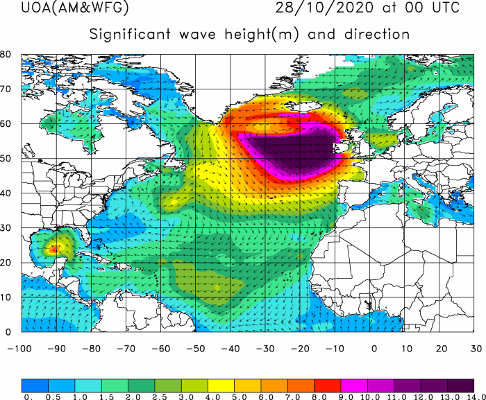
Wintry showers overnight including both snow and ice pellets with some still remaining on the grass on the morning of the 28th. A fine morning with weak sunshine as the sun rose over the mountaintops. A light fall of snow had settled as low as 450 ft on the lower slopes of the Carneddau, but mostly above 1000 ft. Pressure 992 mb was rising, there was a cool SW'ly breeze, the air circulating from Polar Regions, the Denmark Strait and Norway, the result of a low 971 mb S Iceland and W Scotland. The temperature was 3.7C (dewpoint 1.8C) 87% RH. The western fringes had showers the result of packed marine convection to the north-west with frequent cumulonimbus, there was lightning recorded over Cumbria and NWS Ireland. Central England and the SE was mostly sunny (Scilly 8.8C Loch Glascarnoch -6.6C Dunstaffnage 20.6 mm Cardiff 11.0 mm East Malling 6.4h Hawarden 3.3h Valley 1.4h) [Max 5.8C Min 1.1C Grass -2.6C Pptn 0.8 mm].
The month ended with a total of 154.2 mm of rainfall [151%] of average largest since 2016, one of the 13th wettest in Llansadwrn since 1928. It had been mild the mean temperature 6.4C highest since 2016 and the 8th warmest in my records since 1979. A rather dull month, nearly half the number of days in the month were sunless.
February 2020
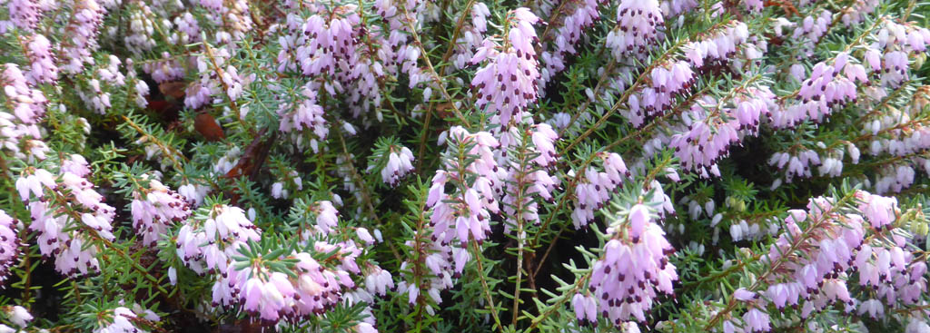
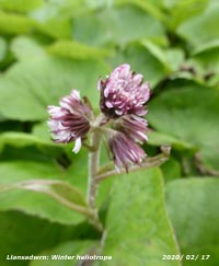
February 1 - a fine breezy morning with the cloud beginning to clear after yesterday's rain and some sunshine developing, visibility was poor in haze. Pressure 998 mb was rising with low 959 mb Norwegian Sea extending a trough to N Scotland. High 1030 North Africa had a weak ridge to the south-west. The W had showers while central England, the E and SE were mostly sunny. The sky turned cloudier around noon and there was a little slight rain and drizzle at times in the afternoon (Charlwood 13.9C Baltasound 3.1C Kinlochewe 38.4 mm Capel Curig 9.4 mm Hawarden 6.6h) [Max 8.9C Min 7.2C Rain 5.4 mm]. The 2nd began dull and damp after some overnight rain. Hardly a cloud in the sky so it was a sunny morning on the 6th with pressure steady on 1032 mb. Pressure was high Europe centre near Verona 1040 mb. Out in the wings were low 991 mb Greenland deepening 975 mb and low 972 mb W of Ireland. There was silver frost on the grass and visibility was good; Snowdon had a light covering of snow/ ice on its NE flank and summit. There was just an air from the SW and soon the temperature was rising from a minimum of 1.3C to 9.8C at 13 GMT. On the sheltered rockery bank a buzzing was heard in the afternoon as several bees, the first of the season, were feeding on masses pink flowering heather (Erica). Valley reported 8.3h of sunshine. Mist and fog lingered in many parts of S Wales and central England (Aboyne 11.6C Gogerddan 10.4C Topcliffe -4.9C Lerwick 2.0 mm East Malling 9.2h) [Max 9.8C Min 1.3C Grass -2.9C Pptn nil].
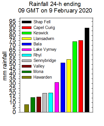
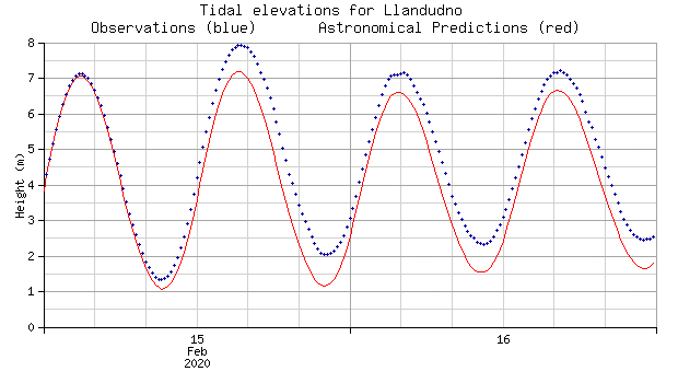
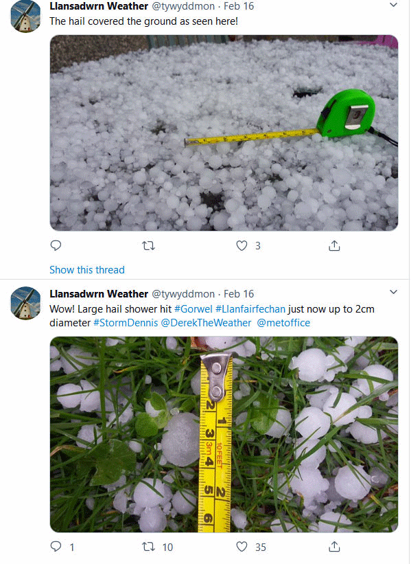
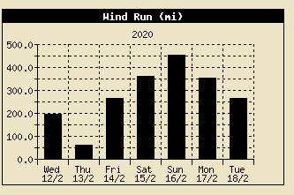
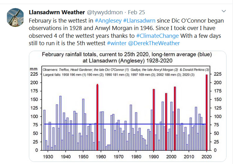
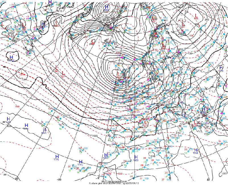
The effects of Storm Dennis began to arrive on the 14th with pressure 1008 mb falling rapidly at 0900 GMT. Dennis was 933 mb SW Iceland and expected to deepen to about 922 mb making it one of the deepest over the North Atlantic in 30-years. The SSW'ly wind was blowing force 7/8 on the exposed side of the Llansadwrn ridge, Capel Curig had reported a gust of 66 mph. A little brightness at first, a glimpse of sunshine the weak sunshine as the cloud on a frontal system over the Irish Sea bringing a band of moderate to heavy rain and rising temperature. Rain ceased in the afternoon as the wind moderated, the temperature rose to 10.7C here and to 11.6C at Gorwel Heights in the warmer air (Murlough 12.7C Gorwel Heights 12.3C Rhyl 11.7C Loch Glascarnoch -9.1C Braemar 20.6 mm Capel Curig 14.2 mm East Malling 6.0h) [Max 10.7C Min 2.8C Grass -1.5C Rain 6.4 mm]. Pressure associated with Storm Dennis S Iceland at midnight on the 16th was 923 mb and was falling again in Llansadwrn 982 mb reaching 981 mb at 03 GMT when the wind was gusting 45 mph. A dry night and overcast morning on the 19th and just starting to rain at 0900 GMT. Pressure 1018 mb was falling, there was an area of rain encroaching on a warm front from the Atlantic to the SW associated with low 957 mb S Iceland. The temperature in the warm moist tropical air rose through the day reaching 8.6C by 19 GMT. The day was sunless, continuous rain was light to moderate and, with little change in the air temperature, turned moderate to heavy before midnight (Scilly 11.1C Baltasound -1.8C Capel Curig 36.2 [62.2] mm Weybourne 5.8h) [Max 8.8C Min 5.0C Grass 3.1C Rain 42.0 mm]. After a rough night with gale-force winds another wet winter's day on the 22nd beginning dull with the WSW'ly wind picking up again. Pressure 1012 mb was rising quickly with low 948 mb NW Norwegian Sea and a very long frontal system stretching from the Baltic across S Britain to just N of the Azores, over 1000 miles. There were two cold fronts passing over Anglesey, the first clearing just before 08 GMT, and the second at 1555 GMT with heavy rain and ice pellets (38 mm/h) that caused the sharpest fall in temperature of the day. Malltraeth Marsh was flooded and there were big waves around the coast on the high tide. Winds reached force 9 around coasts and headlands and gusted to 74 mph at Malin Head (Heathrow 14.3C Braemar -0.6C Lake Vyrnwy 47.4 [48.0] mm [Capel Curig 35.2 mm] Aberdeen 7.0h St Athan 2.7h Valley 0.4h) [Max 8.3C Min 6.5C Pptn 26.4 mm]. A foggy morning on the 23rd at 0900 GMT moderate fog was lifting and the mistle thrush was singing. The ground after 26.4 mm of rain was very soggy and muddy, but pressure 1012 mb was rising quickly with low 989 mb N Scotland, there was a ridge to the W and high-pressure 1035 mb FitzRoy and Spain. Again there was a long frontal system from Finland over S Britain out to the western Atlantic Ocean. Slight rain at 0950 GMT then the sunny breaking through thinning cloud by 1020 GMT and a few sunny spells in the afternoon. Busy in the garden restaking Cistus and other plants blown over in recent gales. The 16.0C recorded at East Malling today was being headlined by the BBC as the highest temperature of the year so far, but we know better as 16.9C was recorded at Gorddinog and 17.4C at Gorwel Heights in Llanfairfechan on the 7th January (East Malling 16.0C Fyvie Castle -1.4C Lake Vyrnwy 44.6 mm Leuchars 8.2h Valley x) [Max 9.4C Min 5.6C Rain 19.2 mm]. The 24th began overcast and after recent rain visibility was very poor with mist. The temperature at 0900 GMT was 9.1C (dewpoint 8,6C) and relative humidity 95%. Blustery too the SW'ly force 6 with gusts 42 mph. Pressure 1001 mb was falling quickly. Llyn Tegid at Bala was deeply flooding the car park and there were waves blown in on the strong wind. Wind moderated during the evening, dry until after midnight (Coningsby 14.1C Hawarden 13.6C Tredegar 8.7C Dalwhinnie -3.3C Capel Curig 54.2 mm Leeming 3.6h Aberdaron 3.1h Valley x) [Max 9.8C Min 3.3C Rain 0.9 mm]. Another overcast morning on the 25th after rain falling after midnight. Pressure 999 mb was still falling with low 979 mb over the North Sea. There were shower troughs bringing marine convection onto W and NW facing coasts. There was some cloud on the mountaintops, but snow could be seen at 2150 ft near the Black Ladders on the Carneddau Mountains. Bright at times with glimpses of sunshine and a shower of 5 mm snow pellets at 1550 GMT. A bright start on the 27th after some wintry showers (snow pellets) overnight with a clearing sky and a cool NNW'ly breeze, a bit chilly 2.9C, but nice to see the sunshine. Pressure 1003 mb was rising with low 987 mb over the English Channel bringing showers to Brittany, S England and Thanet. After 0900 GMT the sky did cloud over for a while before clearing again giving a fine mostly sunny day. Best in the west (Swanage 9.7C Valley 9.2C Lake Vyrnwy 4.8C, Drumnadrochit -4.0C Wych Cross 14.8 mm Morpeth CP 9.7h Valley 8.7h) [Max 8.0C Min 2.6C Grass -2.7C Pptn 1.2 mm]. Back to normal on the 28th with sky overcast, wet and cold. Pressure 998 mb was falling quickly and there was a light to moderate SSE'ly breeze. It was snowing on the Snowdonia Mountains with 'whiteout' on the lower slopes of the Carneddau below the Black Ladders. The month ended with a record total rainfall of 250.6 mm (304%) & [319%] of average largest since before 1979 at this station and before 1928 in Llansadwrn. It had been mild generally the mean temperature 6.3C lowest since 2018, but 12th warmest in my records since 1979.
March 2020#StayingAtHomeMarch 1 - a fine morning with a cold WSW'ly wind it had been bright with some glimpses of sunshine, but recently cloud had begun to increase. Pressure 983 mb was rising with lows 958 mb N Scotland and 993 mb Biscay. Pressure was high 1023 mb over Russia and we were in a showery Polar/ maritime airflow from the region of Greenland. There was some snow on the highest mountain summits in Snowdonia. Some weak sunshine and glimpses of bright sunshine in the afternoon, a slight shower of rain at 1545 GMT then a shower of 6 mm hail at 1628 GMT (Kew Gardens 11.1C Loch Glascarnoch -0.3C Kielder Castle 25.2 mm Manston 9.0h Aberdaron 8.8h) [Max 7.2C Min 3/4C Rain 1.4 mm). The sky was clear overnight at times and early on the 2nd with a moderate ground frost -5.0C, but soon began to cloud over at 0900 GMT 5 oktas cover and increasing soon weak sunshine at times. Pressure 988.6 mb was rising quickly and we were in a polar/ maritime airflow with packed marine convection to the north-west. There was a shower of small ice pellets at 0925 GMT. Mostly cloudy, but dry in the afternoon (St James Park 10.9C Cardiff 10.1C Coningsby -3.1C Kinlochewe 18.4 mm St Athan 9.0 mm Aberdaron 9.2h) [Max 7.1C Min 0.2C Grass -5.0C Rain 2.2 mm]. Rain light to moderate in the small hours of the 3rd with a heavy burst at 0212 GMT that included some ice pellets. At 0900 GMT the sky was brightening in a light W'ly breeze and it was sunny later. Snow showers on the mountains. A sunny afternoon and warm enough for bees to be on the flowering heather rockery banks, and nice enough for a cup of tea to be taken in a sheltered spot. Best in the west today (Cardiff 11.7C Shoreham -2.5C Loch Glascarnoch 11.2 mm Capel Curig 7.8 mm Aberdaron 9.1h) [10.6C Min 3.6C Grass -1.6C Rain trace]. A dull morning on the 4th with slight intermittent rain beginning, precipitation was of snow at 2000 ft on the Snowdonia Mountains where there was lying snow at 2500 ft. Pressure was steady on 1007 mb with a low 1000 mb near the Fastnet Rock, S Ireland, and an occluded front over the Celtic Sea. Low 974 was over the Denmark Strait with marine convection to the north-west of here. The rain did not come to much and the afternoon was cloudy, but dry. Able to do work outside , but no bees and no cup of tea [Max 7.6C Min 2.0C Grass -3.6C Rain 0.4 mm]. Another ground frost overnight -3.0C with slight frost remaining on the grass on the 5th at 0900 GMT. Pressure 1001 mb was steady with low 987 mb Brest, 991 mb W of Malin Head and 984 mb SW Iceland. We were benefiting from a minor ridge N Irish Sea with pressure high 1035 mb Azores. The air minimum had been down to 1.0C, so no air frost so far this month. Cloud cover at 6 oktas a few cumuli increasing, moderate hazy visibility. A fine morning with a light E'ly breeze and some weak sunshine and occasional glimpses, becoming sunny in the afternoon and nice enough for a cup of tea. Best in the west (Porthmadog 10.8C Katesbridge -5.9C Mona -0.5C Herstmonceux 36.2 mm Leeming 8.9h Aberdaron 8.6h) [Max 8.6C Min 1.0C Grass -3.0C Rain nil].
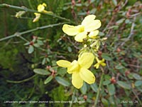
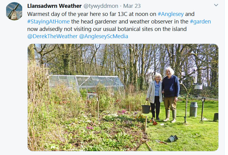
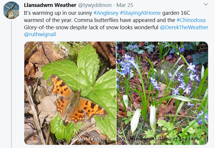
Another cold night with an indicated ground frost minimum -4.7C, but no sign of white frost on the grass on the morning of the 6th at 0900 GMT. The summit of Snowdon had a covering of snow and frost deposition and there was gully snow on several mountain cliffs. A fine and bright, but blustery morning on the 11th after a windy night. Winds were strong in the N and gusting 54 mph in Scotland. It was sunny in the E and East Anglia. Pressure was on 1006 mb with low 959 mb Greenland and a low-pressure area Iceland and N Scotland 972 mb. An occlusion was over the Irish Sea we had showery rain in the morning (10.2 mm/h at 1121 GMT), a mostly cloudy afternoon with the wind strengthening and heavy showers again in the evening (19.6 mm/h at 1940 GMT). The sky cleared later and overnight with the moon visible (Heathrow 15.4C Cardiff 13.9C Aberdeen -0.9C Shap 23.2 mm Capel Curig 12.4 mm Aberdeen 8.5h Aberdaron 4.3h) [Max 9.7C Min 4.7C Grass -1.4C Rain 3.2 mm]. A fine morning on the 12th becoming breezy again. Overnight an air minimum of 2.8C and -2.1C on the grass. Winds were strong in the west with 60 mph seen at Belmullet Head, Ireland, and there had been heavy snow in Tulloch Bridge, Scotland. We had a polar/ maritime air flow today with pressure on 1005 mb there was a low 979 mb near the Western isles with an occlusion near Malin Head. Bright, dry and windy morning and noon turning showery with sunny spells in the afternoon. There was a shower of rain and ice pellets at 1919 GMT (Coningsby 12.0C Dalwhinnie -1.5C Tulloch Bridge 29.4 mm Lake Vyrnwy 7.6 mm Shoeburyness 9.7h Hawarden 7.5h) [Max 8.7C Min 2.8C Grass -2.1C Rain 2.0 mm]. A mostly cloudy morning on the 13th with slight showers before 0900 GMT. It was not so breezy with a light W'ly, moderate visibility and the temperature 6.9C. Pressure 1017 mb was rising with Atlantic-low 1003 mb W of Shannon and an occlusion over the Irish sea. Mostly dull and grey with a little sunshine and light showers of rain in the afternoon not heavy enough to stop work in the garden (Pershore College 13.4C Cardiff 13.0C Katesbridge -2.4C Camborne 11.0 mm Scolton 8.6 mm Loch Glascarnoch 8.6h Aberdaron 4.7h) [Max 9.1C Min 4.1C Grass 0.1C Rain 2.0 mm]. Much the same on the 14th, a little warmer 8.1C at 0900 GMT and mostly cloudy. Recent light showers of rain and poor visibility and another shower at 0930 GMT. Pressure was on 1010 mb with lows 992 mb S Iceland and W of Shannon with an occlusion over the Irish Sea (sound familiar?). The odd glimpse of sunshine (643 W m -2 1139 GMT) otherwise dull with intermittent rain and heavy rain later (16 mm/h at 1957 GMT). Wet in Snowdonia (Northolt 13.9C Kinlochewe -1.2C Capel Curig 23.2 mm Altnaharra 3.2h Valley 2.2h() [Max 10.5C Min 3.7C Grass -1.3C Rain 13.2 mm]. The band of rain overnight was heavy between 0300 and 0330 GMT had passed over and was over SW England, the Midlands and the Wash. A very dull and damp morning on the 15th the ground after 13.2 mm of rain very soggy underfoot. Overcast and cold in the strong SW'ly wind, moderate visibility. Pressure 1002 mb was rising and the cloud thinning at times allowed a little weak sunshine in the morning and glimpses of sunshine in the dry afternoon. Wet in Snowdonia again (Gosport 13.0C Cassley 1.1C Capel Curig 38.0 mm Thomastown 6.9h Valley 5.4h) [Max 11.0C Min 6.5C Grass 4.4C Pptn trace]. The first 15-days of the month had rainfall of 49.9 mm (60%) & [58%] of averages. Temperatures were on the cool side with the mean 6.5C (-0.3) & [-0.5]. No air frosts, but the had been 5 ground frosts. The 16th had been clear overnight and, while there was no air frost, there was a moderate ground frost the thermometer reading -4.3C. Measured frost deposition was equivalent to 0.5 mm of precipitation. In the garden a mass of Chinodoxa 'Glory of the snow' was in flower, no snow this year for it, just a frost. Pressure 1021 mb was rising with a ridge of high-pressure to the SW from Azores high 1031 mb. Broken clouds with bright spells in the morning, bees were seen out briefly, increased in the afternoon and turning cooler in a freshening SW'ly breeze,. There was rain later in the evening (Frittenden 13.8C Aboyne -7.6C Achnagart 22.8 mm Capel Curig 3.8 mm Lyneham 10.5h Hawarden 8.2h Valley 6.0h) [Max 9.4C Min 1.3C Grass -4.3C Rain 13.2 mm]. Light rain continued after midnight on the 17th with moderate bursts at 0130 and 0500 GMT, by morning 13.2 mm had fallen. Precipitation had also been as rain on the Snowdonia Mountains so, apart from surviving snow patches, the summits were snowfree. At 0900 GMT there was thick fog (code 1) and the trees here were imitating a rain forest, drip drip drip. Underfoot the ground was soft and muddy, conditions were dull and dismal. Topped up the squirrel feeding boxes as at the present time they are removing about a litre of monkey nuts and some hazel nuts a day. Some they eat, others they take away and bury. Maybe they will not go back to find all the hazel nuts and they will germinate and produce saplings. I've not seen any yet, of the monkey nuts, who knows? A frontal system was over St George's Channel and Wales all associated with complex low 975 Iceland. With pressure steady on 1023 mb it was becoming brighter at 0945 GMT, the SSW'ly was force 4/5 and strengthening. A sunless day with rain and strong SW'ly wind gusting to 41 mph at 2135 GMT, rain moderate to heavy at times (Santon Downham 15.9C Alice Holt Lodge 0.4C Eskdalemuir 27.2 mm Capel Curig 27.0 mm East Malling 9.0h Hawarden 1.8h Valley nil) [Max 10.7C Min 6.8C Rain 22.2 mm]. Rain continued after midnight, but the wind moderated. By morning 22.2 mm of rain had fallen in the past 24h (09-09 GMT). This time the rain on a cold front (lying Pembrokeshire to the Wash at 06 GMT) turned to snow on the mountaintops and there was some wet snow lying at 2700 ft. A dull, cold and sunless day the maximum temperature today was 6.7C, the lowest of the month (St James Park 16.0C Usk 11.8C, Pennerley 4.7C Lake Vyrnwy 5.5C, Fyvie Castle -0.5C Lake Vyrnwy 3.4C, Capel Curig 21.6 mm, Kinloss 9.4h Valley nil) [Max 6.7C Min 4.7C Rain 22.2 mm]. The 19th dawned brighter with the sky clearing and pressure 1029 mb rising, cool overnight minimum 2.9C with a ground frost -1.1C. Some cloud was lingering, but Atlantic-high 1041 mb was SW of Ireland, with a ridge towards Anglesey and the cloud was thinning, high-pressure would lead to a most dramatic change in the weather pattern through to the end of the month. To the north of us there was an occluded front with showers of rain and snow, to the south there was a warm front with rain. In between, well it was not too bad a day, bright some weak sunshine in the morning and sunny by afternoon, a shade warmer than yesterday. It did turn cloudier later as the front tried to edge back north (St Catherine's Point 12.7C Porthmadog 11.6C, Liscombe & Tredegar 3.8C, Katesbridge -5.0C Sennybridge 1.2C, Mumbles Head 9.6 mm, Prestwick 9.0h Valley 2.7h) [Max 9.2C Min 2.9C Grass -1.1 Rain 0.4 mm]. There was hardly a cloud in the sky on the morning of the 20th, a little cumulus over the Snowdonia Mountains. Pressure 1033 mb was rising with high 1038 mb N of Scotland with a ridge 1036 mb W of Malin Head. Cool overnight, minimum 3.3C with a ground frost -1.7C. There was a light E'ly breeze and the temperature 5.8C, visibility was very good. Worked in the garden, planted out some Swiss chard that had stood all winter in modules; serviced the lawn mowers (Flymo and Honda) and glad I got them running smoothly afte winter storage. A very fine and sunny morning on the 22nd, and unusually quiet even for a Sunday #lockdown. Just 3 oktas of cirrus clouds and good visibility with a little haze. There was drumming from a woodpecker in the wood and I spotted a treecreeper, they are normally quite elusive birds. A cool night with clear sky the minimum had been down to 1.2C and there was a ground frost -2.4C that had all disappeared by 0900 GMT. It was a good day to sow some broad bean seeds in small pots in the greenhouse to bring on before planting out on the vegetable plot. Used our own compost, but could not get supplies from garden centre as confined to the property due to COVID-19 issues #StayingAtHome (Porthmadog 14.3C, Eskdalemuir -3.5C Capel Curig -2.6C, South Uist 2.8 mm East Malling 12.2h Aberporth 11.3h) [Max 11.9C Min 1.2C Grass -2.4C Rain nil], I did spot a little cloud at 0900 GMT on he 26th, 1 okta recorded. Otherwise blue sky with moderate hazy visibility (pollution smoke code 04). Very fine and sunny with a temperature of 9.8C rising to 14.3C just after noon. It would have been a good day to go out on an ecological site visit, but with #lockdown in force I made do with 5 times circuits the garden and wood that is 1 mile. On the 28th intense Atlantic-high was S of Iceland and low 993 mb N Norway had an associated cold front over Scotland. Remnant frontal cloud was charted over N Wales at 06 GMT; we had 6 oktas of cloud cover at 0900 GMT, high cirrus with lower altocumulus lenticularis to the south, clearing later. It was fine, fairly bright and 7.6C, but the force 4/5 NE'ly breeze felt cold. There was sunshine further SW and S England, in Scotland it was snowing at Altnaharra and was lying at 3600 ft on Cairngorm Mountain (Hurn 13.8C Bala -3.1C Resallach 2.4 mm Camborne 11.5h Valley 7.1h) [Max 11.0C Min 3.2C Rain nil]. It was a cold morning on the 29th, the 4.3C bitter in the force 5/6 NE'ly wind. All surfaces were dry, and the ground was hard and showing surface cracking, not by frost (grass minimum 0.7C, but by dryness. There had been no rain for 11 days; and there was none today. Pressure remained high 1046 mb rising with intense high 1055 mb at noon S of Iceland dominating the weather. Sunny at times, but cool the maximum 8.2C fifth lowest of the month (Usk 10.1C Castlederg -2.5C Resallach 4.2 mm Camborne 11.2h St Athan 10.5h Valley 4.6h() [Max 8.2C Min 3.0C Rain nil]. A greater spotted woodpecker had found a very resonant tree branch on which to drum on the 30th as I reached the Stevenson screen for the obs at 0900 GMT. It was dull with a light to moderate N'ly wind and the 6.9C temperature felt chilly. Still no rain to measure, I shook out dust, bud scales and a spider from the rain gauge bottle, no beetles today. Any Saharan dust is currently being transported N around the Atlantic intense-high 1051 mb W of Scotland, the jetstream is also in this position. Any dust we have at the moment is mostly local in origin. It continued breezy in the morning and some sunny sells developed in the afternoon. Farmers have been putting several loads of dung on the field adjacent to the weather station, I suspect it is in preparation for it's rotational ploughing and planting a cereal crop. For the last years cattle and sheep have been grazing this field (Glasgow 13.5C Porthmadog 12.8C, Lo Max Lake Vyrnwy 6.2C, Min Trawsgoed -4.0C, Resallach 7.4 mm, Boulmer 10.7h Aberdaron 7.4h Valley 5.0h) [Max 10.5C Min 3.1C Rain nil].
A very fine and sunny day on the 31st with a few cumulus clouds at first and very good, clear visibility. The 6.8C RH 80% felt chilly in the E'ly breeze. Pressure was 1037 mb with Atlantic=high 1046 mb not quite as intense, remnant cold front central England, showers on the East Coast, The Wash and Maplin Head. But nice in the garden #StayingAtHome did 3 laps of the garden and got on with some pruning jobs. Still #working some contractors for Scottish Power came to coppice trees under a power line going to neighbouring property. They come every so many years to do this, surprised to see them, did not approach kept well clear, did not stay long. Kept dry during the day (Porthmadog 13.0C Katesbridge -2.9C Resallach 4.6 mm Shoeburyness 11.7h Valley 10.4h) {Max 10.9C Min 3.5C Rain 0.4 mm]. In contrast to February the month ended with a rainfall total of 85.7 mm, close to the averages (104%) & [101%], the PWD (Potential Water Deficit) was 34.5 mm. Temperatures were also close to the averages with the mean on 7.0C (+0.2) & [0.0] ranking 19th lowest in station records since 1979. Sunny.
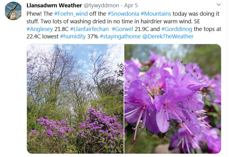
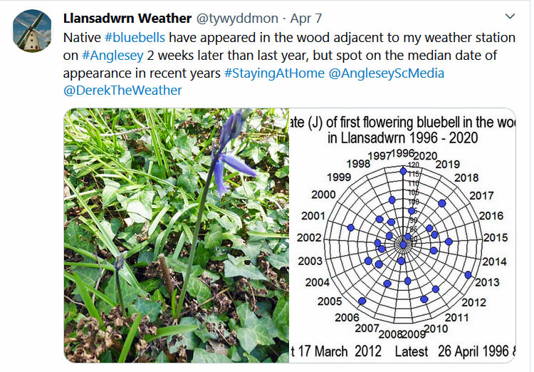
April 2018#StayingAtHome #lockdownApril 1 - began on a dull note with overcast skies, moderate hazy visibility after recent slight rain. April is usually a dry and sunny month in these parts, after the dry end to March we could do with rain. Pressure 1027 mb was falling with Atlantic-high 1039 mb W of Ireland, and a ridge towards western shores, losing intensity. The small amount of rain 1.2 mm overnight had dampened the ground 'laying the dust' so that all monitored surfaces soil, concrete and grass on the morning of the 6th were damp. Not enough by any means to restore the water balance. A fine bright morning with sunshine as any lingering cloud (3 oktas) reduced. Pressure 1013 mb was rising with a low 955 mb SW Iceland and an occluded front over the Irish Sea at 06 GMT. The band of showery rain was now over SE England, otherwise sunny. Potted up seedling tomato plants for the greenhouse and for outdoors eventually when the minimum temperatures are higher (Frittenden 18.8C Dalwhinnie 8.5C, Okehampton 5.3C Tyndrum 16.0 mm Tredegar 9.6 mm Aberdaron 12.3h Valley 11.5h) [Max 13.6C Min 8.3C Rain nil]. A very fine and sunny morning on the 7th, I was pleased to hear a blackcap singing the first this season joining the chiffchaff that arrived on the 24 March. No sighting here of house martin or swallow. Visibility was very good with slight haze, a snow patch was still visible on Yr Wyddfa. With pressure on 1029 mb and high 1031 mb not far away over the S North Sea, the jetstream was set well to the N of the UK, a fine day was expected. The temperature was 11.2C and though it did not rise to yesterday's heights the 16.3C in the afternoon was not too bad in a sheltered spot in the garden (Northolt 20.4C Cardiff 17.7C Aberdaron 12.9C, Sennybridge -3.1C Baltasound 2.6 mm Aberdaron 12.5h Valley 12.1h) [Max 16.3C 4.3C Grass 1.2C rain nil]. After an almost clear overnight sky and a very bright moon, apart from early weak glimpses of the sun on the morning of the 8th moderately high altostratus cloud had encroached. It was fine and the temperature 14.1C and pressure steady on 1026 mb. Visibility was very good and clear of haze. Pressure was low 1023 mb over Biscay and 984 Norwegian Sea. There was a cold front over the N of Scotland and a detached warm front over the English Channel. Not to worry, it was sunny by afternoon and several first sightings of holly blue, orange tip, large white, and small tortoiseshell butterflies. Peacocks seen earlier were also seen, but not comma. The wild cherry was starting to bloom on the top of the tree, no leaves yet. The garden has got very dry and some irrigation of flower beds was necessary (Herstmonceux 23.9C Aberporth 15.5C, Kielder Castle -0.5C Mona 1.8C, Lentran 8.4 mm Morpeth 12.0h Aberdaron 9.7h Valley 7.7h) [Max 18.9C Min 7.0C Rain nil] Much the same on the 9th albeit broken cloud at 0900 GMT. Pressure steady on 1025 mb with high 1029 mb stationed over the N of Scotland, frontal cloud was over the Borders. Very fine, feeling pleasantly warm, butterflies around the garden. Air pollution ozone moderate level 4 in places including N Wales. Soil moisture level under grass determined today 44% dm was drier than in April and August 2019. On the uncultivated bare met plot it was 14% dm just lower than the permanent wilting percentage 15% for the local soil. All the temperatures in the soil profile 5 - 100 cm read 10C, or more this morning, for the first time this year; 5 cm 12.9C; 10 cm 10.7C; 20 cm 10.4C; 30 cm 11.0C; 50 cm 10.5C; and 100 cm 10.0C. A pleasant evening with little wind and a bottle of beer (Wiggonholt 24.4C Usk 24.1C, Kinbrace -6.7C Glasgow 2.6 mm Bournemouth 12.1h St Athan 11.8h Valley 10.2h) [Max 20.9C Min 8.3C Rain nil]. The 10th began fine and warm after a mild night air minimum 11.5C, warmest since 16 January (11.6C). The temperature at 09 GMT was 18.5C with RH 61%. Broken cloud some cumulus with high cirrus clouds. Visibility was moderate with thick haze the result of air pollution and Saharan dust. Ozone levels were moderate level 5 in N Wales (Machlyn Mawr), Cardiff City centre, Cwmbran and Port Talbot (source: Air Quality Wales). I had noticed that seedling sensitive tomato varieties had leaf marks typical of ozone damage. Very fine and sunny day, it was our turn for a warm 22.4C in the Föhn-enhanced breeze, highest maximum of the year so far (Gorwel Heights 20.2C & Gorddinog 20.6C). Pressure was on 1023 mb in a ridge from high 1034 mb SE North Sea in command. Some cloud encroached by evening (Bude 25.0C Trawsgoed 24.8C, Loch Glascarnoch 1.9C Thomastown 7.6 mm Bala 3.6 mm Shoeburyness 12.6h St Athan 12.2h Valley 9.5h) [Max 22.4C Min 11.5C Rain nil]. A fine and warm morning with scattered clouds in hazy sunshine on the 11th, after an overnight minimum of 11.5C, highest of the month so far, the temperature 15.3C at 0900 GMT. Pressure 1024 mb was rising in a ridge from Azores high 1032 mb to central UK. Visibility was poor (< 2 km) in thick haze (smog) a combination of Saharan dust and air pollution. The ozone level at Marchlyn Mawr was a level 5, but was low for NOx level 1. Cardiff City centre ozone was on level 2 and Port Talbot level 3 (source: Air Quality Wales). Despite there being less traffic on the A55 (cameras) the road here seemed just as busy #lockdown. The wild cherry tree had blossom from top to bottom branches today, it is loved by the birds especially chiffchaff and blackcap. Did not quite make 20C today (St James Park 25.5C Cardiff 25.0C, Santon Downham 2.1C Baltasound 6.4 mm Aberporth 12.3h Valley 10.6h) [Max 19.8C Min 11.5C Rain nil]. A fine, but cooler (11.8C) and dull morning on the 12th with moderately high altostratus and cumulus clouds. Visibility had improved and was good to very good with the mountaintops in the clear. The ozone level at Marchlyn Mawr was level 3 and Cardiff City centre and Narberth 2 (source: Air Quality Wales). Pressure was high 1035 mb between Scotland and Iceland, but pressure here 1014 mb was falling with low 1006 mb over Biscay pushing frontal systems our way with a cold front reaching here at 1530 GMT. This weak system produced next to no rain here, but some mixed source dust fallout, and a slow fall in temperature. Llanfairfechan AWS Gorwel had 0.8 mm and Gorddinog 1.0 mm c. 1830 GMT. Hawarden reported 10.2 mm and dust fallout was reported in Wilmslow in heavy rain (St James Park 25.0C Usk 21.6C, Dalwhinnie 1.0C Hawarden 10.2 mm Reading University 11.4h) [Max 15.2C Min 9.0C Rain 0.1 mm]. After yesterday's minor disturbance the weather on the 13th was back to being fine and sunny. Hardly a cloud in the sky, but a moderate ENE'ly breeze that made the 7.4C at 0900 GMT feel rather fresh. Pressure 1029 mb was rising again with high 1035 mb unusually placed between Scotland and Iceland. A dry sunny day (Cardinham 14.4C Pembrey Sands 14.3C, Dalwhinnie -0.7C Pennerley 19.4 mm Hawarden 3.2 mm Rostherne 12.9h Valley 12.7h) [Max 11.1C Min 5.2C Rain nil]. With high pressure 1030 mb (UK) dominating our weather it was another fine sunny morning on the 14th with just a little cumulus cloud appearing at 0900 GMT. Overnight there had been a ground frost -1.8C, the air temperature went down to 1.5C but, Valley reported an airfrost -1C. The NNE'ly breeze was light, but the 9.3C still felt a little cool. It was a cold day in the NE, at Newcastle after an airfrost -4C the temperature struggled to reach 6C in the breeze off the North Sea and made the 12.5C reached here positively balmy. Manchester reached 10C after an airfrost of -2C. Our Bardsey apple tree has started to flower, earlier than last year when it did not flower until 7 May. Planted out 3 rows of broad beans raised from seed in the greenhouse, they are more successful here grown like this, in the past I have had the seed taken by mice and the small seedlings eaten by slugs. The larger plants stand a much better chance. There was an aircraft flying around today, there have been none for a while. An aerial survey has been carried out in the area of the Carneddau and Llyn in recent days, the flight path did pass over here. The coastguard helicopter, usually busy, has also not been seen #lockdown (Helens Bay 16.8C Bala 15.3C, Redesdale Camp -6.7C Capel Curig -3.1C, Baltasound 3.2 mm Aberporth 13.1h) [Max 12.5C Min 1.5C Grass -1.8C Rain nil]. Very fine and sunny again on the 15th with very good visibility and slight haze. Pressure was steady on 1024 mb. A jet aircraft flew by at 0944 GMT. The NE'ly breeze strengthened through the day (Durham 21.2C Usk 18.6C, Katesbridge -4.2C Cassley 1.4 mm Eskdalemuir 13.3h Aberdaron 13.1h) [Max 15.6C Min 3.7C Grass 0.2C Rain nil]. The first 15-days of the month had been very sunny and dry with rainfall of just 1.9 mm (4%) & [3%] of averages. Temperatures were on the warm side with the mean 11.1C (+1.9) & [+2.2]. No air frosts, there had been 1 ground frost. Another glorious day #StayingAtHome in the garden on the 16th, plenty of jobs to do (running behind with weather updates) and the bluebells in the wood are about at their best. The ramsons, wild garlic, is flowering now and we are continuing to use it as salad, adding the odd flowering stem beloved by chefs, and a few very nutritious dandelion leaves. I have not tried the flowers yet... Traffic past the weather station seemed less this morning and birdsong sounded brilliant. Visibility was good, it was moderately hazy with Marchlyn Mawr monitoring station reporting level 3 ozone pollution, the forecast however was for level 4 to 5 (source: Air Quality Wales). A small amount of cirrus clouds and an ENE'ly breeze, a pleasant 19.1C in the afternoon, and no rain (Bude 21.8C Porthmadog 21.7C Gorddinog 21.1C, Santon Downham -2.1C Bala -1.1C, Resallach 1.0 mm, Morecambe 13.1h Aberdaron 12.0h) [Max 19.1C Min 6.6C Rain nil]. On the 17th the bud scales have started falling off the opening buds on the trees. They are sticky, are a problem to clear up and stick to your shoes and get in the house. Otherwise one welcomes the new light green foliage of spring as will the birds when the insects emerge. It was another fine morning with a few cumulus clouds and just good visibility in thick level 4 smoke haze. A fly in the ointment is a slow-moving low 1005 mb just off cap Finisterre pushing weather up to Brittany and beyond. There were sferics seen in the Channel off Caen, France. Rain was seen on the radar at Porthmadog and Llyn at 10 GMT. Mostly sunny at first, cloud developing rather quickly and a maximum of 14.0C reached at 1328 GMT. Cloud thickening in the afternoon and a heavy localised shower of rain at 23 GMT in the evening, not seen in Llanfairfechan (Porthmadog 18.1C, Tredegar 9.4C, Aboyne -5.4C Lake Vyrnwy 5.7C, Thorney Island 20.6 mm St Athan 10.0 mm' Stornoway 13.6h Valley 3.9h) [Max 14.0C Min 6.0C Rain 7.2 mm]. A fine morning on the 18th with a little weak sunshine. After the shower of rain in the night surfaces were damp and plants in the garden had perked up. The 7.2 mm was sufficient to ensure that this April would not be the driest in Llansadwrn on record, the 9.0 mm so far now exceeding the 6.7 mm recorded at this station in 1980. Pressure 1018 mb was rising with slow-moving low 1011 mb over the Celtic Sea. There was band of cloud over the N Irish Sea and Liverpool Bay, with another over St George's Channel. Little in the way of sunshine today, with a maximum daytime temperature of 11.9C at 1316 GMT, and the afternoon increasingly dull with some spits and spots of rain sufficient to give up gardening activities for the day (Aviemore 16.5C Pembrey Sands 13.8C, Lake Vyrnwy 5.2C, Aviemore -5.4C Lake Vrnwy 3.0C, Lyneham 25.6 mm Usk 9.2 mm, Stornoway 13.7h Valley 0.9h) [Max 12.7C Min 6.4C Rain 0.3 mm].
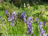
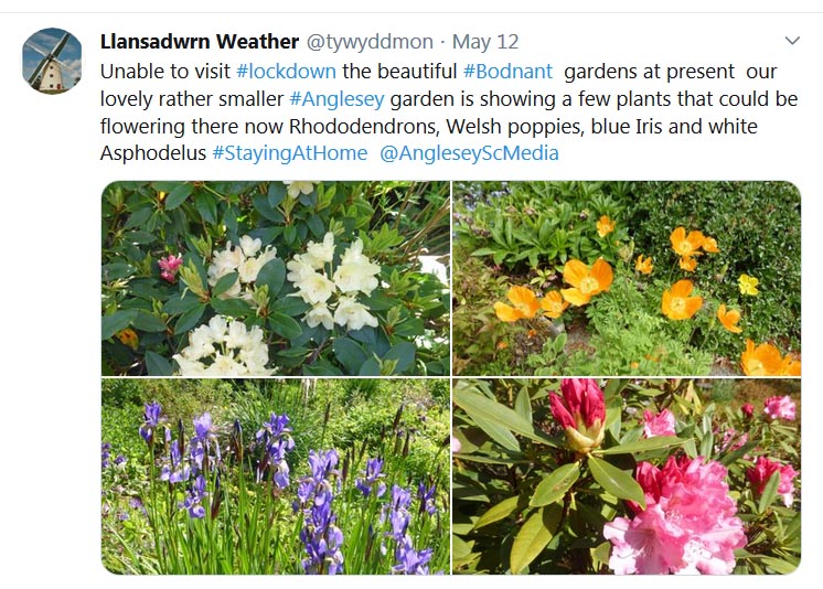
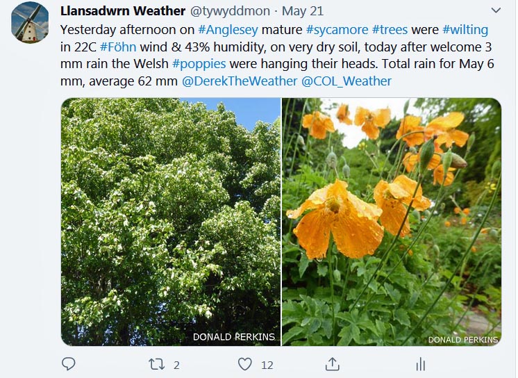
The 19th was a beautiful bright and warm morning. Being a Sunday it was quiet, and no church services and bells because of #lockdown. I walked around the wood with bluebells and wild garlic at their best, no traffic, no sounds other than the vibrant singing of so many birds, blackbird, robin, thrush, persistent great tit, agitated wrens and a sudden resonant drumming of a woodpecker, a startled pheasant and the whisper of a gentle SE'ly breeze in the treetops. I must not forget the aroma of wild garlic underfoot in places - it was a remarkable treat. The 20th began without a cloud in the sky with good visibility and moderate haze the result of pollution ;smoke' and Saharan dust. With a moderate NE'ly breeze all surfaces were dry, the 8.9C at 0900 GMT felt 'fresh'. Trees hereabouts are greening up noticeably quickly, beech a nice pale green colour in particular, Cattle are now grazing the fields near the weather station, the sheep have been moved off somewhere else. Best in the west Cardiff 19.1C, Braemar -5.7C Bala 1.3C, Baltasound 0.4 mm Kinloss 14.2h Aberporth 13.5h Valley 13.0h() {Max 16.0C Min 4.8C Rain nil]. Well there was just a little cloud today the 21st, a lenticular altocumulus cloud had formed just to the S, it did not persist very long It was feeling very fresh in the strong ENE'ly breeze with a temperature of 9.9C, this rose to 18.0C in the afternoon and if you found a sheltered spot it was quite warm. Orange coloured Welsh poppies are in flower in the garden and the blue irises are budding up, these usually give a spectacular display later on. An elm tree, a survivor of the Dutch Elm Disease that affected the wood greatly in the 1970s, was in flower. Soil moisture under grass (2-8 cm) determined today was 39.1% dry mass down from 43.8% dm on the 8th. The top 2 cm consisting of mainly compacted roots and grass containing most of the moisture was 46% dm, down from 69% dm on the 8th. On the undisturbed met plot 0-8 cm deep was 15.2%, similar to that at the beginning o the month. On the vegetable plot, that has a larger organic matter content (part not irrigated), 0-8 cm was 20.7% dm and 8-14 cm was 24.5% dm. The permanent wilting percentage for the soil here is 15% dm. We do have a very dry event and need rain. It is remarkable that this situation has arisen so quickly after the wet months of February and March, this is not only due to having had just 8.8 mm, but also the above average temperatures and high evaporation rates. Today's ET (AWS calculated evapotranspiration) was 3.5 mm, the total this month to date 55.2 mm. You can read about a previous dry spell in March and April 2003, and concerns about soil water here and about the 18-day drought in May 2004 here (Porthmadog 20.9C Fair Isle 10.7C, Braemar -5.9C Sennybridge 2.9C, Scilly 2.6 mm, Kinloss 14.2h Hawarden 13.4h Valley 11.4h) [Max 18.0C Min 6.2C rain nil]..
It was sunny everywhere on the morning of the 22nd
with just 1 okta noted here at 0900 GMT. All surfaces were dry, except the lysimeter where there was heavy guttation. Pressure was steady on 1022 mb with high 1037 mb S Norway unmoved. Low 1006 mb was over the Med with disturbed weather, a detached occlusion was off SW Ireland and over Charente Maritime. Fine and sunny here, but there was a slowly moderating force 5 NNE'ly so finding a sheltered spot was best, it was warm in the afternoon with a maximum of 18.2C (Hurn 22.6C Porthmadog 22.3C, Braemar -4.8C Bala 1.5C. St James Park 0.2 mm, Kirkwall 13.8h St Athan 11.9h Valley 11.4h) [Max 18.2C Min 6.2C Rain nil]. A mostly cloudy start to the day on the 23rd with weak sunshine cloud decreasing with sunshine later. A little warmer, 12.6C at 0900 GMT rising to 18.9C in the afternoon. Pressure steady on 1022 mb with high 1030 over the Norwegian Sea, Erected temporary extra staging in the greenhouse to accommodate pricked out seedlings growing for the herbaceous border and indoor / outdoor tomato plants (Herstmonceux 24.3C Porthmadog 23.1C, Fair Isle 8.5C Aberporth 15.5C, Altnaharra -4.1C Bala 1.6C, Houghton Hall 0.2 mm, Kinloss 14.2h St Athan 12.4h Valley 7.1h) [Max 18.9C Min 8.0C Rain nil]. The 26th began very murky with very poor visibility, fog was reported at Valley. At 0900 GMT visibility was still poor partly due to poor air quality. Marchlyn Mawr monitoring station was reporting level 5 ozone concentrations compared wit the centre of Cardiff level 2. There were glimpses of weak sunshine and ground conditions remained 'dry as a bone', there was slight guttation on grassy areas this morning. Pressure 1012 mb with high 1014 mb off east Anglia. A light SW'ly freshening as a weak cold front was here about 15 GMT, the SW'ly wind backing NNE'ly. Did potting up of tomato plants currently Tumbler F1 for outdoor, Fandango and Mountain Magic, I normally grow my own, which is just as well as unlikely to get any from garden centres closed for #lockdown. Brittany Ferries appear to be operating normally for freight traffic viewed online via 'shipais'. The Company started out bringing cauliflowers from Brittany to Britain and expanded into car and passenger traffic. We have been with them many times over the years to holiday in France (Holbeach 22.4C Cardiff 19.5C, Santon Downham -1.7C Whitechurch 2.9C, Normanby Hall 8.2 mm Gogerddan 1.2 mm, Wattisham 13.5h St Athan 9.9h Valley 2.3h) [Max 13.4C Min 8.1C Rain 0.2 mm].
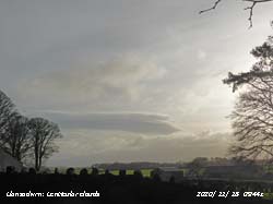
The 29th began bright and sunny, but by 0900 GMT the sky had clouded over, the mountaintops were obscured although visibility under the cloud was very good. Pressure 998 mb was falling quickly with low 987 mb W of Ireland tracking towards the Isle of Man. An occlusion was over the Celtic Sea while low 1003 mb was over the southern N Sea with an associated warm front over Anglesey. There was slight rain at first then some sunshine before a spell of rain before noon. The sky cleared in the afternoon, I took a #lockdown photograph from my usual snow observation station, there was none. Later, cloud encroached as the wind strengthened and there was some more rain around 21 GMT ceasing before midnight. Rainfall of 7.8 mm was the largest of the month () [Max 12.4C Min 5.6C Rain 7.8 mm]. It had been cold enough overnight for snow to fall on the mountaintops of Snowdonia, but at 0900 GMT on the 30th with 8 oktas cloud cover the summits were hidden from view. Pressure was 998 mb with the low 986 mb centred near the Isle of Man. The jetstream is now re-established to the S of the UK over France and N Spain and we have more unsettled cooler northern weather to end the month. The airflow today was from polar regions of the NW Norwegian Sea past Iceland. The temperature was 6.8C the lowest since the 1st of the month, rising to only 8.5C at 1540 GMT making this the coldest day of the month, but the maximum of 9.3C was just before 0900 GMT tomorrow the 1st of May which by convention is credited to the 30th April. There was slight showery rain and the garden was looking all the better for it the plants looking much fresher. Showers continued to affect the W and N while to the E there were sunny intervals before showers developed there too. In the evening a heavy shower of 5 mm hail was reported in Wilmslow (Kinlochewe 16.0C Cardiff 13.3C, Shap 0.9C Sennybridge 3.8C, Capel Curig 33.8 mm, Manston 8.9h St Athan 4.7h Valley 0.1h) Max 9.3C Min 5.3C Rain 2.8 mm]. A sunny and warm month. Temperatures above averages, the mean highest since 2011 was 11.1C (+1.9) & [+2.2] ranked 3rd in station records since 1979. The rainfall total of 25.1 mm, close to the averages (47%) & [40%], least since 2010 ranked 9th in Llansadwrn records back to 1928.
May 2018#StayingAtHome #lockdown May 1 - fine and sunny, but the 9.1C at 0900 GMT was feeling fresh in the air flow from the Greenland Sea. Pressure 998 mb was rising with a complex low-pressure system 989 mb off Wick 991 mb North Sea having an occlusion over Cumbria and W Scotland at 06 GMT, the North Sea low was 993 mb at 0900 GMT moving towards the Baltic. Ozone concentrations were down this morning level 2 at Marchlyn Mawr the same as Cardiff City centre and Port Talbot (source: Air Quality Wales).
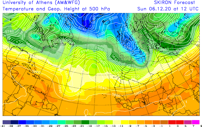
Mostly sunny in the afternoon the cloud lifting to reveal a little snow left on the tops of the Carneddau and Snowdon, there were a few widely spaced showers around, we caught one of rain at 1930 GMT (Edinburgh Botanic Gardens 16.1C Usk 15.1C, Katesbridge -2.1C Lake Vyrnwy 4.0C, Myerscough 12.0 mm Llysdinam 6.2 mm, St Athan 11.4h Valley 8.3h) [Max 13.7C Min 5.7C Rain 0.3 mm]. I tried to find a bit of cloud somewhere in the sky on the 6th, but there was none. It was sunny and dry, all surfaces that I record, very good visibility and it felt a little warmer, the 14.2C at 0900 GMT very pleasant indeed. With pressure 1015 mb would rise and we were within UK high 1028 mb centred near Newcastle. The 9th dawned bright and with a light NE'ly breeze soon warmed up when the sun had risen enough above the mountains and our local tall trees. At 0900 GMT it was 17.1C, a shirt sleeves morning for the obs, very pleasant. Pressure was on 1014 mb we were in a slack area of low pressure 1013 mb Western Isles, between highs 1032 mb N Greenland and 1020 mb E Med. Some cloud was lying far to the north-west. A chilly night with some clear sky there was slight white frost on the fields at dawn on the 12th, the grass minimum read -2.7C, no airfrost here the minimum 2.0C, but Mona airfield recorded -1.3C. Temperatures have been below average during the first 15-days of the month and very dry with rainfall of just 0.3 mm. The mean temperature 10.5C (-1.1) & [-1.2] less than in April. No air frosts, there had been 3 ground frosts. A much nicer day on the 16th beginning with scattered cumulus and high cirrus clouds. Visibility continues very good and all surfaces were dry, except the lysimeter that was wet with guttation droplets. Very fine and sunny on the 17th and with slight haze good visibility. Pressure 1023 mb was falling slowly with high Brest and lows 998 mb Norwegian Sea and 991 mb S of Greenland. Frontal cloud over N and NW Scotland with some rain. Here fairly breezy with cumulus and cirrus clouds, warm in the sun kept dry (Holbeach 21.1C Hawarden 18.9C, Kirkwall 8.6C Capel Curig 13.4C, South Newington 1.3C, Dunstaffnage 15.4 mm, Tibenham 12.8h Aberporth 3.8h) [Max 16.3C Min 8.6C Rain 0.3 mm]. The 18th was a very dull day under thick cloud at 0900 GMT solar radiation was was just 120W, a far cry from recent mornings,also thick enough for slight rain and drizzle with 0.3 mm measured. Recorded the ground as wet this morning, the first time in 15 days. A patch of showery rain was slow-moving over Anglesey. Showers also NW Britain although the SE was sunny. Light showers in the morning. It was 33C in Greece; overnight minimum of 10.1C around 03 GMT, 10.9C at 0900 GMT rising to 11.8C at 1826 GMT. Total rainfall here this month 3.0 mm, so far (Cavendish 24.6C Usk 19.1C, Lerwick 7.9C Capel Curig 10.9C, Baltasound -1.0C Libanus 7.2C, Achnagart 24.8 mm Capel Curig 5.2 mm, Exeter 13.3h St Athan 8.8h Valley 0.0h) [Max 12.0C Min 10.1C Rain 2.4 mm]. A dull breezy morning on the 19th after some light showers in the night. Recorded the ground as wet again this morning and despite the rain there were still cracks in the surface. The temperature had been 12.0C at 0833 GMT, the highest of the past 24h. Pressure 1023 mb was rising , the high 1027 mb over Brittany was diminishing. Low 995 mb S of Iceland had a frontal triple point over Scotland. Slowly a little less dull, no more rain, and by afternoon some sunny spells developing. Up to 8 May there have been 174 cases of COVID-19 recorded in Anglesey and 12 attributed deaths (St James Park 26.2C Usk 23.1C, Altnaharra 1.8C, Blencathra 19.0 mm Capel Curig 1.0 mm, Wellesbourne 13.4h Aberporth 13.0h Valley 3.6h) [Max 16.3C Min 10.6C Grass 10.2C Rain nil]. The 20th began very fine, sunny and warm. A very windy morning on the 23rd the SW'ly force 5/6, but fine and mostly sunny. Pressure 1015 mb was rising with low 976 N of Scotland, pressure was high near Cap Finisterre 1032 mb. There were scattered showers in the north and also south Midlands. Here blustery sunny spells and a slight shower in the afternoon (Weybourne 20.1C Bodelwyddan 16.6C, Dalwhinnie 4.9C, Achnagart 68.2 mm Lake Vyrnwy 11.6 mm, Reading University 11.4h St Athan 10.1h Valley 7.0h) [Max 14.9C Min 9.9C Rain trace]. Fine, but dull on the morning of the 24th, moderate visibility and quite hazy. Very dry, a bit breezy and as a result feeling chilly although 13.1C at 0900 GMT. The afternoon was brighter with some sunshine and the temperature rose to 17.4C. Sowed runner beans (Moonlight) in pots in the greenhouse, made sure they were in the propagating frame so that the mice did not find them. We have woodmice permanently in and out of the greenhouse and they love seeds. It was a rather murky morning on the 26th with poor visibility, moderate haze with fog reported in places including Aberporth. The sky was overcast with altostratus cloud and the grass damp, there was a drop of precipitation in the raingauge bottle. Pollution levels were low, there was a patch of Saharan dust over Britain (SKIRON Model University of Athens) and there was a dusty deposition likely a mixture of local and Saharan dusts. Pressure was high 1037 mb over the Scilly Isles, and here 1037 mb rising, a plume of warmer air was encroaching southern Britain where hot and sunny. There has been a complete absence of housemartins and swallows here, numbers seen had decreased last year. Heavy losses have been reported on migration routes this year. Climatic changes in the swallows' African winter quarters and on migration routes may be having a serious impact. Research has shown that swallows are returning to their breeding areas in poor condition and are laying fewer eggs than previously. Independent of weather-related fluctuations, there have been widespread declines in swallow numbers across Europe since 1970 (Kew Gardens 26.9C Usk 23.8C, Tulloch Bridge 4.0C, Tyndrum 1.6 mm Gogerddan 0.2 mm, Exeter 14.6h St Athan 14.1h Valley 5.6h) [Max 17.6C Min 11.2C Grass 7.9C Rain nil]. Very fine and sunny on the 27th, very dry conditions with no sign of rain any time soon. Warm, 16.7C at 0900 GMT rising to 21.7C in the afternoon. Pressure steady on a high 1038 mb centred on Malin Head (1039 mb at midnight) covering a large area of Europe and north Africa. Cloudy to the N of here, but cloudless skies over much of eastern Europe, France and Iberia. Planted out sweet peas grown in pots in the greenhouse and potted up chrysanthemum cuttings (Heathrow 26.3C Usk 25.3C, Shap 1.0C Capel Curig 3.4C, Stornoway 2.4 mm Wales nil, Nottingham 14.7h St Athan 14.2h Valley 13.4h) [Max 21.7C Min 7.9C Grass 3.7C Rain nil].
A sunny, warm and very dry month. The rainfall total of 11.9 mm, (17%) & [19%], was least on record in May in Llansadwrn records back to 1928. Sunshine at RAF Valley was most in May in Anglesey records back to 1931. Temperatures above averages, the mean highest since 2017 was 12.7C (+1.1) & [+0.9] ranked 7th in station records since 1979..
June 2020
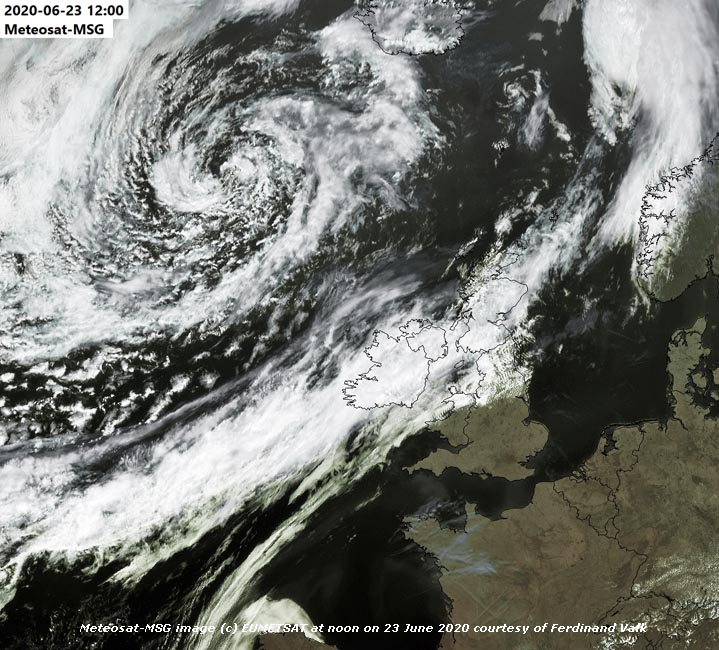
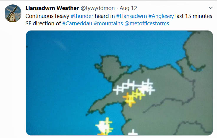
June 1 - a very fine and warm day, cloudless sky very clear visibility, a continuation of the remarkably fine weather of May, but I expect we will pay for it soon, the forecast charts don't look promising from midweek. Pressure was on 1025 mb with high 1033 mb S Norway. Sunny and warm out of the NE'ly breeze. The temperature at 0900 GMT was 18.0C with 59% RH excellent for drying the washing and getting on with those jobs in the garden (Porthmadog 27.6C Aboyne 1.1C High Mowthorpe 0.2 mm Waddington 15.6h Aberdaron & Valley 15.5h ) [Max 21.1C Min 12.3C Rain nil]. Just a little cloud on the morning of the 2nd, low hiding behind the Snowdonia Mountains to the south. Warm again 20.4C at 0900 GMT and continuing warm, rising to 23.9C was very pleasant in the garden. We keep susceptible plants watered and where necessary on the vegetable pots. Leaves on mature woodland trees show a little wilting in the drying breeze. We could do with a drop of rain, but not the end of the summer. Pressure 1022 mb with low 1020 mb S Iceland and a cold front over N Scotland associated with low 1001 mb Svarlbard, expected to move south. Made the most of the lovely summer day, the last for a while Gosport 26.9C Ravensworth 2.9C Strathallan 13.4 mm Bournemouth 14.6h St Athan 14.1h Valley 12.1h() [Max 23.9C Min 11.9C Rain 2.8 mm]. Well we had the drop of rain after midnight on the 3rd that by the morning had accumulated just 2.8 mm measured in the raingauge at 0900 GMT. A change in the weather with colder air introduced from the north overcast sky with a frontal system over Anglesey. A dust deposition, local plus some Saharan dust was possible, being cleared away south-eastwards during the day. Poor conditions prevented any outside work, a clearance from 5 pm brought a little sunshine to end the day. The maximum 12.1C was lowest of the month (Cavendish 20.9C Whitechurch 16.8C, Altnaharra 4.9C, Shap 19.2 mm Hawarden 18.6 mm, Magilligan 11.5h Valley 4.3h) [Max 12.1C Min 11.3C Rain 2.9 mm]. Overcast sky again on the morning of the 4th with a slight shower of rain at 0900 GMT. Pressure was on 1007 mb with complex lows 996 mb Netherlands and frontal-wave 999 mb SW Norway. A cold front was clearing over the Dover Strait into France. Pressure was high 1030 mb over the Atlantic to the W of Ireland. Dull all day, sunless here (Murlough 18.6C Cardiff 16.7C, Aboyne 1.3C Sennybridge 2.4C, Drumalbin 17.0 mm Sennybridge 3.0 mm, Kirkwall 6.1h St Athan 1.9h) [Max 15.4C Min 8.7C Rain trace], A bright start to the 5th with broken cumulus clouds (7 oktas cover) solar radiation was 809 W m -2 much being reflected back by the clouds. The temperature was 11.4C (RH 70%), pressure steady on 999 mb with low 984 mb over the Norwegian Sea. There was a cold front over the English Channel and here a cold NNW'ly breeze. Sunny spells in the afternoon, solar radiation brightness reached 1116 W m -2 at 1300 GMT with the cumulus clouds persisting (Bournemouth 19.2C Cardiff 17.7C, Redesdale 2.0C, Hull 24.4 mm Sennybridge 9.8 mm, Shobdon 11.7h Valley 10.4h) [Max 15.2C Min 7.7C Grass 3.8C Rain 0.4 mm]. A colder and wet breezy day on the 6th with poor to moderate visibility in slight drizzle. Pressure on 998 mb was slowly rising with low 982 mb over the North Sea off Tynemouth. There was a frontal-wave triple point over Morecambe Bay. Pretty windy elsewhere with gusts of 52 mph reported at Loftus, 45 mph at Malin Head and 43 at Aberporth. Brighter and drier in the late afternoon (Pershore 19.3C Hawarden 16.0C, Libanus 3.8C, Drumnadrochit 42.6 mm Capel Curig 30.4 mm, Hawarden 8.9h Valley 1.0h) [Max 13.9C Min 7.0C Grass 2.8C Rain 0.9 mm]. Pressure 1010 mb was rising on the 7th with filling low 997 mb southern North Sea near the Netherlands coast. Overcast with spots of rain and drizzle and moderate to good visibility. The morning became dry by 10 GMT and the afternoon was bright with spells of sunshine developing later as the sky cleared. There was a bright moon seen over the mountains just before midnight (Wiggonholt 20.5C Usk 20.3C, Shobdon & Usk 3.4C, Fylingdales 16.4 mm Cardiff 3.4 mm, Prestwick 10.6h St Athan 8.0h Valley 6.3h) [Max 16.1C Min 9.6C Grass 8.7C Rain trace]. Cool overnight under clear sky with a minimum 6.2C and 1.8C on the grass. A recent light shower of rain on the 10th did not wet the soil surface, but dampened the concrete and grass. Signs of the mostly cloudy sky opening up with a little brightness, then thickening and closing again. Pressure 1014 mb was falling with a low closeby over the North Channel at 0900 GMT. Occlusion cloud over the Irish Sea and a lot of rain at Mumbles near Swansea. There was high-pressure N of the Azores 1033 mb and Norwegian Sea 1027 m b. Little in the way of any sunshine, more at Tiree island not far to the north-west of Anglesey. Showery rain in the evening (Manston 17.5C Porthmadog 16.8C, Castlederg 5.6C, Mumbles Head 49.0 mm, Tiree 5.6h Valley 2.0h) [Max 16.6C Min 10.1C Rain 4.0 mm]. Overcast, dull, damp and breezy on the 12th, but it was fine and by 10 GMT some glimpses of sunshine. Again the housemartins were giving a fine display in the sheltered corner of the field/ Two or three flying over and inspecting the eaves of the house. Pressure 1010 mb was falling with low 977 mb Biscay and Charente Maritime, France. There was a trailing occlusion over the Irish Sea and the sky became increasingly dull in the afternoon thickening enough to bring on drizzle at 15 GMT. The highest temperature was 16.4C at 1127 GMT, that would have been regarded as a good summer temperature here 30/40-years ago. The 24-h maximum 17.7C was at 09 GMT tomorrow when warmer Continental air was being drawn across central Britain. Not good for outside work, sowed purple sprouting broccoli 'Rudolph', kale, chard (Beta vulgaris) and spinach in modules in the greenhouse. Wet in Loftus (41.6 mm) the town lying within the county of North Yorkshire. It lies in a region between Saltburn-by-the-Sea and the North York Moors, it was formerly known as Lofthouse (Tyndrum 23.2C Milford Haven 22.3C, Braemar 2.4C, Loftus 41.6 mm Cardiff 15.0 mm, Loch Glascarnoch 12.2h Aberdaron 8.6h Valley 2.5h) [Max 17.7C Min 10.5C Rain 0.2 mm]. The 13th began sunny and warm with an ENE'ly breeze, scattered clearing clouds, cirrus, altocumulus and cumulus, as an area or rain pushed northwards in N England and Newcastle where over the North Sea a group of sferics had earlier been recorded. With pressure on 1008 mb there was complex slow-moving low-pressure over Biscay and the Charente Maritime where the weather was poor. Warm air from the S was pushing against colder air in the N, a recipe for thunderstorms. A MetO Yellow warning had been issued for N Wales. We had a slight shower at 1450 GMT, just a few drops, and no thunder was heard. Storms did develop in the evening on a line from London to Liverpool (Porthmadog 25.5C, Edinburgh Botanic Gardens 12.4C Tredegar 18.6C, Exeter 7.7C Whitechurch 7.9C, Chillingham Barns 14.0 mm Scolton 8.2 mm, Wattisham 13.6h Aberdaron 9.4h) [Max 20.4C Min 12.9C Rain trace]. The first 15-days of the month have had nearly half of the normal June rainfall 33.0 mm (43%) and [49%] of averages, but not enough to fully restore the water balance. The mean temperature 13.8C a little below normal (-0.5) and [-0.1] of averages . Overcast at first on the 16th with a mild 15.8C air temperature at 0900 GMT. here was a low 1014 mb over the SW Approaches and another 1012 mb over the Baltic, we were in a large slack low-pressure area with 1015 mb here. Visibility was moderate in haze and there was just a light NE'ly breeze that felt fairly warm, if not muggy. There had been a light deposition of dust, a greyish colour with tones of light reddish brown. The SKIRON model indicated patchy Saharan dust over the UK and it's likely it was mixed with local and European dusts. Yellow warnings were out for thunderstorms and sferics were already in the vicinity of the Black Mountains of S Wales. There was a little brightness and glimpse of sunshine around 10 GMT. Sferics spread widely across Britain during the day. Thunder was heard at 1418 GMT and again later from the SE in the direction of the Carneddau Mountains. Fog developed late in the afternoon then cleared during the evening. Storms continued in the Midlands and N England late into the evening dying out before midnight (Heathrow 24.9C Usk 23.4C, Whitechurch 7.0C, Market Bosworth 49.6 mm Llysdinam 45.0 mm, Lerwick 13.1h St Athan 6.5h) [Max 20.5C Min 11.6C Rain 2.5 mm]. Fog returned just after midnight on the 17th and there was a spell of light to moderate rain from 01-03 GMT, it was still foggy at 0600 GMT. At 0900 GMT visibility was poor in mist, but the cloud was thinning a little and was brighter. The temperature was 15.1C (dewpoint 14.3) RH 95%. There was a shower of rain at 0920 GMT. Thunderstorms developed again in SW England, S Wales and Thannet. There was flooding of streets and property in the Rhondda Valley where the villages of Pentre and Maerdy were flooded some for the third time this year. Storms Ciara and Dennis left Wales with an estimated £180m clean-up bill and more than 1000 properties affected in Rhondda Cynon Taff (Source: BBC 19.6.20) an area also badly hit by the COVID-19 pandemic. Sporadic thundery outbreaks occurred again over SE and central England, S Wales and Cumbria. Thunder was heard from about 1325 GMT followed by showery moderate to heavy rain up to 12 mm/h, further light showers around 2200 GMT. Localised storms occurred along the N Wales coast (near Rhyl) in the evening (Writtle 24.8C Bala 23.2C, Lerwick 7.3C, Sutton Bonington 40.6 mm Libanus 19.8 mm, Morecambe 9.8h Hawarden 5.2h) [Max 19.4C Min 12.6C Rain 3.4 mm]. Fog returned after midnight on the 18th and by morning visibility had improved, but was still poor with mist and slight rain at 0900 GMT. Pressure was on 1011 mb with low 1008 mb over the North Sea just off East Anglia where they were getting some welcome rainfall. An area of moderate to heavy rain was spreading from the ESE westward. MetO yellow warnings were in place for thunderstorms in southern Britain; Anglesey, Pembrokeshire and Cornwall were excluded from heavy rain warnings. We would be in the rain shadow of the Snowdonia Mountains as it was coming unusually from the east and not the prevailing southwest on this occasion. It was a dull day, slight rain and drizzle in the morning and a wet afternoon, heaviest at 1507 GMT when falling at 4.2 mm/h though the total was moderate. Not fit to do any outside jobs today (Achnagart 24.5C Porthmadog 17.9C, Aboyne 4.9C, St Athan 50.0 mm, Altnaharra 13.4h Aberdaron 0.5h) [Max 15.8C Min 13.7C Rain 9.6 mm]. Another poor day for gardening on the 19th, but not the garden that has needed the rain with the soil still on the dry side. At 0900 GMT poor misty visibility with heavy drizzle. With pressure steady on 1008 mb we had a low-pressure centre over the Irish Sea, pressure was high 1021 mb France. Similar miserable misty wet weather in the afternoon, very wet in Porthmadog (25.0 mm), but it did start to clear too late in the evening when a few glimpses of sunshine were seen (Altnaharra 22.2C Hawarden 18.4C, Altnaharra 7.6C, Salsburgh 26.6 mm Porthmadog 25.0 mm, Manston 9.4h St Athan 3.5h) [Max 15.3 Min 12.1C Rain 5.0 mm]. A very windy day on the 22nd, at 0900 GMT with pressure steady on 1019 mb there was a S'ly force 6 to 7, force 8 had been forecast for the Irish Sea, unseasonable for this time in June, but not unusual. Overcast, conditions were dry here, but rain was on the radar off South Stack and the Llyn. The sneaky low was 1003 mb off Malin Head with a triple point SE Ireland at 06 GMT, pressure was high 1028 mb relatively closeby over Brittany, as a result isobars were tight to the W and NW including the Celtic Sea. The day continued dull and breezy with strong gusts. There was light rain from 16 to 20 GMT (Heathrow 23.9C Cardiff 22.8C, Aboyne 2.3C, Eskdalemuir 17.2 mm Whitechurch 14.6 mm, Shoeburyness 15.5h St Athan 9.4h) [Max 16.4C Min 10.9C Rain 1.0 mm].
The 24th began very fine and sunny with 4 oktas cover of cirrus clouds. Pressure was on 1021 mb in a ridge of high-pressure from high 1028 mb over S Norway to Wales. There was lingering frontal cloud to the NW that was not to bother us. The warmer air had reached us and winds were light. The local farmer took advantage of the light wind and sprayed the adjacent barley field which is growing up well. Sunny with the temperature reaching a warm 23.8C here in the afternoon. Hot in parts of southern Britain (Heathrow 32.6C Cardiff 30.0C Harris Quidnish 14.5C, Redesdale 8.1C Mona 8.3C, Port Ellen, Islay 15.2 mm, Morecambe 15.4h Aberdaron 15.0h) [Max 26.4C Min 11.7C Rain nil]. The 28th dawned mostly cloudy and very windy. At 0900 GMT pressure 1003 mb was rising with slow-moving, but filling low 987 mb near N Scotland. Visibility was moderate with rain in sight. The weather was sunny in the SE, but again in the NW there were light to heavy showers. A mostly cloudy day, with rain and or drizzle almost throughout, heaviest at 1509 GMT 3.8 mm/h, and strong to gale-force SW'ly wind. Rain duration (wet hours) were 17 in the 24-h period. Coolest day with 13.6C since the 3rd 12.1C (Heathrow 22.0C Cardiff 17.6C Blencathra 10.8C, Okehampton 8.9C, Kielder Castle 48.0 mm Lake Vyrnwy 28.4 mm, Manston 11.9h Aberporth 6.1h Valley 0.8h) [Max 13.6C Min 11.2C Rain 14.2 mm]. The 29th was a very dull and sunless day, low hill fog on the Snowdonia Mountains where very wet. Cooler than of late and windy too the WSW'ly force 5 moderating through the day. A 0900 GMT there was just 65 W m -2 of solar radiation and this improved to only 269 W m -2 at 14 GMT some 25% of what could be expected this time of year. Pressure 1005 mb was rising with low 988 mb little changed still N of Scotland. An occlusion was sitting over N Wales and the cloud base was about 500 ft with drizzle at times here. Not much precipitation in daylight hours, light rain after midnight of duration 5 hours. Wet at Capel Curig (Heathrow 21.7C Cardiff 17.0C Lake Vyrnwy 10.7C, Dalwhinnie 8.4C, Capel Curig 34.6 mm, Manston 8.7h St Athan 1.6h Valley 0.0h) [Max 13.6C Min 10.5C Rain 1.8 mm]. The 30th and the last day of a strange June, the record setting weather events and COVID-19 pandemic issues, not that we have seen the end of either. Well, it had stopped raining at 0900 GMT after all night drizzle and rain. The sun was starting to break through the mostly cloudy sky. Cool, bright and wet, but not the end of 4-days of unseasonable weather. Pressure was not seeing much change with low 992 mb on the southern tip of Norway it was 1005 mb here. The day kept mostly cloudy with showery rain at times duration 9 hours. Pressure had fallen to 1002 mb at 1800 GMT when we had a short spell of heavy rain on a frontal system and quick fall in temperature of 3C from 16C (Weybourne 21.9C Hawarden 19.5C, Lake Vyrnwy 9.5C, Ballypatrick Forest 9.8 mm Bala 3.4 mm, Tiree 10.5h Bala 2.1h Valley 0.8h) [Max 15.9C Min 11.1C Rain 4.6 mm] . The month ended with a rainfall total of 102.4 mm (144%) & [151%] of averages largest since 2017, one of the 19th wettest in Llansadwrn since 1928. The mean temperature was 14.7C (+0.5) & [+0.8] of averages highest since 2018 and the 12th warmest June in my records since 1979. The 31.3C on the 25th was the highest recorded in June at this station since records began in 1979 Despite 6 sunny days (>10h) it was a dull month overall, the 137.5 h sunshine at RAF Valley the 9th lowest on the Anglesey record back to 1931. There was an unusually high number of thunder events, but no hail .
July 2020
July 1 - began in a dull and wet manner . At 0900 GMT with the sky overcast it was misty with drizzle imparting moderate visibility. The temperature was 14.0C with 95% RH, rising to 16.8C at noon. Pressure was 1003 mb in a trough of low-pressure N Wales and N England within a large area low 976 mb centred N Finland. It rained on and off most of the day (Weybourne 21.9C Hawarden 19.5C, Exeter 9.5C, Ballypatrick Forest 9.8 mm Bala 3.4 mm, Tiree 10.5h Bala 2.1h Valley 0.0h) [Max 16.8C Min 11.7C Rain 12.8 mm]. Early light showers of rain on the 6th with a mostly cloudy sky in the morning. Pressure 1020 mb was rising quickly and the jetstream still over southern Britain, but here on the edge we had some sunshine in the afternoon with the highest solar radiation 1055 W m -2 as a transient ridge from Azores high 1033 mb developed. I have waited a while to get a photograph of one of the red-tailed bumblebees Bombus lapidarius we ave in the garden, today I succeeded Sunniest in the north (Pershore 22.3C Cardiff 30.3C, Braemar 7.5C, Myerscough 11.8 mm Capel Curig 1.4 mm, Glasgow 11.3h Aberporth 8.0h Valley 5.7h) [Max 18,1C Min 10.3C Rain 1.4 mm]. A fine bright morning on the 10th for a change, chilly overnight the air minimum 7.8C and 4.4C on the grass with moderate dew. It was already sunny in Penmon and eastward at Llandudno, and NW Anglesey at Rhosneiger at 0900 GMT. There was a NW breeze and this is always results in cloud over Llansadwrn (7 octas) the result of close proximity to the Carneddau Mountains. Pressure 1020 mb was rising with Azores high 1027 mb stretching as far as W Ireland. Later with scattered cumulus clouds we had frequent sunny spells in the afternoon (Shoreham 21.2C Cardiff 18.9C. Kinbrace 4.2C, Spadeadam 16.8 mm Whitechurch 1.4 mm, Bude 13.8h Aberdaron 13.4h Valley 10.0h) [Max 17.3C Min 7.8C Rain nil]. A tad more W in the breeze this 11th morning with a WSW'ly, but it did not make a lot of difference to the cloud cover with 7 octas. Visibility was very good and it was a lot warmer than expected 15.2C at 0900 GMT after a minimum of 7.9C and 3.8C on the grass. Pressure 1028 mb was rising within the high over the Celtic Sea. The NW fringe was mostly cloudy, but it was sunny in the S and E of the country. Clear and sunny at Rhosneiger and with easing of #lockdown cars were already lined up parked alongside the A5 at Tryfan. Some sunshine at times, if you were in the shade it felt chilly. Picked 3 lbs of blackcurrants (Gosport Fleetlands 23.1C Cardiff 21.0C, Benson 3.8C Sennybridge 4.0C, Loch Glascarnoch 4.0 mm Rhyl 0.2 mm, Aberdaron 14.6h Valley 12.4h) [Max 18.3C Min 7.9C Rain nil]. With a SSW'ly breeze cloud cover was 6 oktas on the 12th at 0900 GMT, visibility was excellent and clear. Quite sunny at times and especially in the afternoon and feeling warmer, but still a bit chilly if in the shade. Pressure was steady on 1028 mb UK high. Sowed a row of Oregon sugarpod peas, the third in succession to keep up the supply for the kitchen. Picked broadbeans for dinner. Kept dry through daylight hours (Heathrow 25.2C Usk 22.9C. Sennybridge 1.3C, Harris Quidnish 5.4 mm, Shoeburyness 14.9h St Athan 12.9h Valley 7.2h) [Max 19.3C Min 9.3C Rain 8.6 mm] Rain after midnight on the 13th, light to moderate and heavy around 0630 GMT. Recent rain, overcast and very dull under thick cloud W m -2 at 0900 GMT, poor visibility with low fog on the slopes of the Snowdonia Mountains. The strong SW'ly wind was suiting the 10 wet-suited kite surfers out on the water at Rhosneiger, and they didn't mind the rain. Not suitable for gardeners, perhaps with wet suit, but not for me. There was a low 1005 mb between Iceland and Scotland with a cold front over the North Channel, we were in warm sector air. Despite the cloud and intermittent drizzle the amount of rainfall was only 0.2 mm. The day was sunless, but to the SE of here it was mostly sunny and hot in places (Shoeburyness 26.4C Cardiff 20.2C, Fair Isle 13.2C Sennybridge 15.0C, Goudhurst 6.5C, Scolton 17.0 mm, Shoeburyness 10.8h Lake Vyrnwy 0.5h) [Max 16.1C Min 13.6C Rain 0.2]. Dull again on the 14th beginning fine with good visibility and calm. The grass was very wet and a fairy ring was evident showing up in the moist conditions. The webcam view from Moelfre across Red Wharf Bay towards the mountains was a study in grey. A poor day for July, a shower in the afternoon and sunless here. Light rain from 1700 GMT with moderate fog developing in the evening (Heathrow 23.1C Cardiff 20.4C, Topcliffe 7.4C, Altnahinch 12.4 mm Mona 3.2 mm, Leuchars 7.9h St Athan 1.7h Valley 0.3h) [Max 15.3C Min 11.6C Rain 5.6 mm]. Much the same on the 15th showery rain in the small hours, grey clouds to ground level looking towards the mountains with mist and drizzle. Very wet everywhere, trees dripping with moisture. Light level low again 120 W at 0900 GMT the day sunless. Inside work today (Leuchars 21.0C Milford Haven 19.6C, Giants Causeway 13.2C, Houghton Hall 7.1C, Altnahinch 10.0 mm Trawsgoed 6.8 mm, Manston 6.5h Aberporth 0.9h Valley nil) [Max 14.9C Min 11.9C Rain 0.9 mm]. The first 15-days of the month have been wet and cool. Rainfall of 104 mm was more than the usual for the whole month with (119%) & [149%] of averages. The mean temperature well below normal 13.6C (-2.2) & [-2.1] of averages and the mean maximum 16.2C remarkably (-3.2) & [-3.3] of averages . Continuing the unseasonable dull and wet weather the 16th began, well yes, overcast dull and misty with slight rain and drizzle. Cloud was just on the tops of the Snowdonia Mountains.
The 21st dawned fine, but disappointingly dull with the sky overcast with moderately high cloud just touching the tops of the Snowdonia Mountains; solar radiation was 153 W m -2 at 0900 GMT. The 22nd began bright and showery with signs of the sky clearing, but this was not to be. There was a blustery moderately strong SW'ly air from northern Arctic regions. Pressure 1022 mb was falling slowly with a minor low 1013 mb off the Hebrides. Early morning fog on the 25th was clearing away at 0900 GMT visibility then moderate. Very dull solar radiation just 132 W m -2 reaching 234 W m -2 just after noon, the temperature 14.5C with 96% RH felt muggy. Thunderstorms developed later in Devon and South Wales spreading to central England, the Welsh Borders and NE Scotland, giving us a miss (Coningsby 25.6C Hawarden 21.4C, Baltasound 10.6C, Craibstone 35.6 mm Capel Curig 24.6 mm, Leuchars 5.6h Hawarden 2.2h Valley 1.0h) [Max 15.9 Min 14.4C Rain 0.3 mm]. A fine, but breezy and again dull morning on the 26th with pressure 1008 mb rising things improved a little. There was a complex low NW Scotland this having associated occluded frontal cloud Western Isles, Ireland and here. It was brighter by 10 GMT with glimpses of sunshine continuing mostly cloudy, but dry through the day. Slight rain came along during the evening (Teddington 24.2C Hawarden 20.7C, Katesbridge 7.8C, Harris Quidnish 10.6 mm Tredegar 5.0 mm, Tiree 9.6h Aberdaron 5.5h Valley 2.7h) [Max 18.4C Min 11.7C Rain 17.8 mm]. Moderate to heavy rain after midnight on the 27th and a dull grey to ground morning with very poor visibility. It was sad to see the garden being battered by the S'ly force 6/7 'gardeners' gale' with rain making the plants heavy, but pleased to see many flowering plants on the herbaceous border, that the head gardener lovingly spends many hours tending, standing up to it well. I keep the tomatoes well tied in to stakes on the vegetable plot, guy ropes on the row of runner beans and potted chrysanthemums tied in although there was some damage to these. A few Bardsey and Gaerwen pigs' snout apples had been blown off, I picked them up but they are still too small to do much with. Pressure 996 mb was falling rapidly with low 994 mb Ireland with frontal triple-point near Bardsey Island at 06 GMT tracking to the Isle of Man 995 mb by 0900 GMT. Early thunderstorms developed in Somerset and S Wales tracked towards the Home Counties. Cloudy all day until the frontal system with well defined edge cleared slowly at noon to give a sunny fresh afternoon. Rainfall total up to 171.0 mm chasing the July record 182.1 mm recorded here in 2010 (Pershore 22.9C Hawarden 20.8C, Fyvie Castle 4.1C, Shap 35.8 mm Capel Curig 28.8 mm, Lerwick 6.2h Valley 5.1h) [Max 18.4C Min 11.7C Rain 4.2 mm]. A bright start on the 28th after a cool night 6.0C on the grass, convective cumuli were forming at 0900 GMT. Pressure 1014 mb was rising rapidly the low now 986 mb off Aberdeen gusting 48 mph at Wick. Pressure was high 1022 mb SE from Greenland and with a NW'ly breeze it was fresh with polar maritime air introduced having closed and open cell marine convection over the Atlantic to the north-west. There was a slight shower at 0915 GMT otherwise dry. Some sunshine at times, the Llansadwrn convergent cloud formed at noon persisting into the afternoon, occasionally sunny (Shoreham 23.0C Cardiff 19.2C, Killylane 7.9C Libanus 9.3C, Fair Isle 24.0 mm Rhyl 1.0 mm, Aberporth 11.3h Valley 9.6h) [Max 17.3C Min 10.7C Rain trace]. A fine bright morning on the 29th with some thinning moderately high altostratus. Very good clear visibility and feeling warmer Pressure was steady on 1020 mb with lows 995 mb S Norway and Iceland the latter having frontal cloud mass over SW Ireland where raining. High 1022 mb near Brittany had a ridge to Cardigan Bay and Anglesey. Frontal cloud and rain over central England, fine and sunny south coast, East Anglia and NE England and Scotland. Warmer air from the south was being introduced with rising temperatures here, this when meeting the cooler northern air could lead to instability later. (Heathrow 24.5C Usk 21.3C, Exeter 4.5C Usk 6.0C, Resallach 10.0 mm, East Malling 13.5h St Athan 7.7h Valley 3.7h) [Max 16.9C Min 10.8C Rain 2.2 mm]. Showery rain came along from midnight on the 30th amounting to 2.2 mm by morning. A fine morning with the sky clearing and very good visibility. Pressure steady on 1016 mb with low 990 mb S Iceland and a warm front over the N Irish Sea. Feeling warmer 16.4C at 0900 GMT in the plume of warm air from the south rising to a pleasant 22.8C at 3.30 pm in the afternoon (Heathrow 29.7C Hawarden 26.9C, Tulloch Bridge 2.0C, Dundrennan 17.4 mm Valley 4.2 mm, Wattisham 14.9h St Athan 13.6h) [Max 25.7C Min 13.2C Rain nil]. The overnight air minimum of 14.8C was highest of the month. It kept very fine, sunny and warm on the last day of July the 31st with a clear sky at 0900 GMT and remarkably for here a hot temperature of 25.7C 55% RH that by convention was credited to the 30th. The temperature rose to a maximum of 27.4C at 1141 GMT, highest of the month. Cloud encroached just after noon to give a mostly cloudy afternoon taking the edge off the temperature 21C at 1500 GMT. there was a shower of rian before midnight (Heathrow 37.8C Kew Gardens 37.3C third highest temp on record Hawarden 30.7C, Shobdon 8.3C Bala 10.1C, Ryhill (W Yorks) 10.8 mm, Weybourne 13.5h Hawarden 8.7h Valley 7.6h) [Max 27.4C Min 14.8C Rain 2.2 mm]. The month ended with a rainfall total of 179.6 mm (205%0 & [257%] of averages wettest since 2010 and 2nd wettest July on record in Llansadwrn since 1928; the mean temperature 14.6C (-1.3) & [-1.1] of averages was coolest since 2012 rank 7th in station records since 1979; there was a notable absence of thunder and hail; dullest since 2012 at Valley rank 17th on Anglesey record since 1931. August 2020
August 1 - the last month of meteorological began on a pretty poor note with the sky overcast in contrast to the last days of July. It was raining and visibility was very poor as much of the NW of Britain. The SE was fine with sunny spells or clear sunshine. Pressure 1015 mb was rising and there was a little improvement by afternoon that had a sunny spell towards the end. The maximum today? Well 10C lower than yesterday (Heathrow 27.7C Usk 21.9C, Tulloch Bridge 14.5C Sennybridge 16.3C, Derrylin Cornahoule 8.9C, Altnahinch 14.8 mm Valley 6.8 mm, Waddington 10.9h St Athan 9.8h Valley 3.3h) [Max 17.7C Min 13.4C Rain 2.2 mm]. A fine and breezy morning on the mostly cloudy morning of the 2nd an back to normal with a cooler airflow and a recent shower of rain. Pressure 1017 mb was still rising slowly with low 990 mb Iceland and 997 mb Nova Scotia resulting in the W'ly flow. Pressure was high 1027 mb over the Azores. Various shower troughs were charted in the west and Ireland and we had a few through the day, otherwise sometimes bright (Heathrow 25.4C Usk 21.7C, South Newington 6.5C, Killylane 18.2 mm Mona 3.2 mm, Shoeburyness 10.2h Aberporth 10.1h Valley 4.9h) [Max 18.2C Min 12.1C Rain 1.2 mm]. A fresher feel on the 3rd after a cool night 7.3C on the grass, with very good visibility. Cloud was increasing and here were showers in the vicinity. Pressure was on 1018 mb with low 999 mb SE Iceland and low 989 mb S of Greenland over the Atlantic to the west. The temperature was 14.6C and there was a light WNW'ly breeze. A mostly cloudy, but dry day with infrequent sunny spells. Lifted my row of Angus potatoes, bought in for the kitchen that had sprouted planted during lockdown, quite pleased with the result there is nothing like boiled new potatoes to have with roast dinner (Gosport 24.2C Usk 20.4C, Eskdalemuir 3.1C Sennybridge 6.1C, Rhyl 11.8 mm, Yeovilton 13.0h St Athan 11.0h Valley 8.0h) [Max 17.8C Min 10.2C Grass 7.3C rain 1.2 mm]. A rather poor morning on the 4th with overcast sky looking grey to ground level in mist and slight rain. Low 990 mb was S of Iceland and there was a warm front over Ireland where at Bellmullet the wind was gusting 45 mph. A sunless day the blustery wind strengthening to 35 mph and turning very wet late afternoon and evening, The AWS raingauge malfunctioned due to the petiole of a leaf entering the funnel outlet and preventing tipping, not had that one before. On inspection next day there was also a slug found inside the housing, had that before when slime ruined the sensor that had to be replaced, but no problem on this occasion. The official copper gauge is always manually read at 0900 GMT which caught 23.5 mm (Heathrow 24.9C Usk 21.0C, Aboyne 3.4C Usk 5.3C, Tyndrum 71.0 mm Sennybridge 4.8 mm, Manston 13.4h Hawarden 1,4h Valley nil) [Capel Curig 53.8 mm Mona 10.4 mm Valley 6.2 mm Hawarden 1.0 mm] [Max 16.7C Min 11.1C Grass 7.5C Rain 23.5 mm]. The 5th continued the autumnal theme with masses of browned leaves dropping from the beech trees, at times looking like snow, almost covering the ground in laces aided by a blustery force 5 SW'ly. Visibility was poor with mist and slight rain and drizzle. There was minor damage all over the garden with some potted plants blown over and broken chrysanthemum stems despite the tying up done. Low 978 mb Iceland had a triple-point frontal wave SW Ireland and a warm front straddled the Irish Sea. So warm, 16.4C at 0900 GMT rising to 18.7C just after noon, and moist although the total precipitation collected over the 24h was only 0.6 mm (Santon Downham 28.4C Cardiff 22.7C, Frittenden 11.6C Tredegar 14.3C, Capel Curig 55.4 mm, Shoeburyness 12.5h St Athan 2.7h) Capel Curig 16.4 mm Lake Vyrnwy 10.4 mm ] [Max 18.7C Min 13.9C Grass 12.0 Rain 0.6 mm]. After midnight on the 6th deep radiation fog fog developed under clear sky. By morning it was still misty with visibility moderate and cloud forming. At 0900 GMT the temperature was 17.7C (dewpoint 16.9C) 95% RH. The grass was very wet with dew and fog deposition. Pressure was on 1015 mb in a generally slack area around Britain, a low was developing W of Ireland 991 mb and the old frontal system was over the Channel and N Sea. Best of the weather where sunny was N Scotland and N northern England. Here mostly cloudy, but North Wales tourist spots in the mountains and beaches on Anglesey were busy (Wisley 30.1C Hawarden 24.5C, Altnaharra 6.0C Mona 10.7C, Plymouth 3.8 mm Sennybridge 1.6 mm, Kinloss 13.9h Aberdaron 2.8h Valley 2.1h) [Max 19.7C Min 13.2C Grass 9.0C Rain 0.6 mm]. There was some rain after midnight on the 7th and still cloudy at dawn, but the sky was clearing slowly at 0900 GMT with cloud lifting from the Snowdonia mountaintops in very good visibility. Pressure 1017 mb was rising with a low 990 mb Iceland and cloud associated with a cold front over Ireland encroaching the north-west. Feeling warm, sunny spells in the afternoon and a sunny evening. Hot at Gorwel Heights, Llanfairfechan 25.3C and the south (Heathrow 36.4C Usk 29.0C, Harris Quidnish 15.7C Aberdaron 17.1C, Exeter 10.4C, Magilligan 14.2 mm, Wattisham 12.1h St Athan 9.9h Valley 5.7h) [Max 22.3C Min 15.8C Rain nil]. A very fine morning on the 8th with just a little contra with cirrostratus far to the SSW, clear very good visibility. Pressure was on 1024 mb and there was a light NE'ly breeze. The fine weather again attracted many people to the beaches with the A55 on to the island at a standstill at times; car parks soon filled up including Llyn Tegid, Penypass and Ogwen. Sunny, but cool in the north hot again in the south (Herstmonceux 34.5C Usk 30.1C, Drumnadrochit 4.3C Mona 12.0C, Lerwick 2.0 mm Aberporth 0.8 mm, Edinburgh 14.3h Valley 13.6h) [Max 22.0C Min 14.2C Rain nil]. A fine and sunny, but breezy morning on the 9th with many leaves falling like snow from the tall trees giving an autumnal look. Beech in particular lost that vivid green colour some while ago, now pale and some quite brown. The soil surface was drying in the wind, but not 100% dry. Pressure was on 1020 mb and it was a warm 18.3C at 0900 GMT. Central England began cloudy and misty, the N Scotland, SE England and Anglesey were sunny. Hot in the south (Herstmonceux 34.0C Hawarden 24.3C, Aboyne 1.5C, Bridlington 0.6 mm, Kirkwall 14.2h Valley 12.8h) [Max 22.0C Min 14.2C Rain nil]. The 10th began fair, but mostly cloudy with poor visibility. There was a thundery low 1011 mb over the Charente Maritime, France and a trough over Cornwall and NE England. The MetO had issued a yellow warning for thunderstorms, sferics were observed early in the Severn estuary and the NE coast of England. Storms soon spread over Cornwall, S Wales and Aberystwyth where there was flash flooding. Large thunderstorm over the Carneddau and Llanfairfechan with torrential rain at 1450 GMT at Gorwel Heights, 19.2 mm fell in 20 minutes with 24.4 mm in total during the 1 hour event from 1440-1540 GMT and a 24-h total of (26.2 mm). The Aber road out Llanfairfechan was flash flooded and some road surfaces damaged. Gorddinog AWS reported no rain in that hour, but had less intense rain earlier and later with a total of (17.2 mm). Llansadwrn had no rain in the specified hour, but had 1.4 mm from 1450-1510 GMT and a total of (2.0 mm) in the 24-h (00-00 GMT). Heavy thunder was heard in Llansadwrn and frequent lightning seen during the event. A spectacular lightning strike on the Menai Strait near the Anglesey shore was photographed by Rhian Toghill from Caernarfon (Heathrow 35.5C Usk 25.8C, Altnaharra 3.1C, Chivenor 27.8 mm Whitechurch 19.2 mm, Weybourne 13.3h Hawarden 3.9h) [Max 20.7C Min 15.1C Rain 1.8 mm]. Fog developed after midnight on the 11th and with very little wind visibility was still very poor by morning. Pressure 1016 mb in a slack thundery low pressure system. There was fog on the bridges, signs of the fog/ cloud thinning with some weak sunshine developing. Feeling warm the temperature 18.4C with 96% RH. Fog persisted around the coast for a while before the temperature rose to 25.5C at 1429 GMT. Sultry into the evening. Thunder was heard at 2207 GMT and 2218 GMT with lightning in the clouds (Heathrow 35.7C Usk 30.8C Aberporth 17.9C, Kinbrace 5.9C, Morecambe 51.6 mm Lake Vyrnwy 39.6 mm, Bournemouth 12.3h Hawarden 10.9h) [Max 25.5C Min 15.3C Rain nil]. A bright start on the 12th, after an overnight minimum of 15.3C a sunny and warm morning the temperature at 0900 GMT 20.6C and somewhat humid at 92% RH. The 13th began very fine, sunny and warm, at 0900 GMT the temperature was 23.7C with 81% RH. There was thick haze, but visibility was good. The cereal field adjacent to the weather station was sprayed at 1024 GMT. The sky cleared and the afternoon was warm. Sferics were recorded near the tip of Llyn about 20 GMT. Flash flooding due to storms occurred in the Home Counties and M25 (Porthmadog 29.8C, Harris Quidnish 11.2C, Newport (Salop) 38.8 mm Aberdaron 21.4 mm, Morecambe 12.7h Valley 10.4h) [Max 24.8C Min 18.3C Rain 1.6 mm]. After a short heavy shower of rain a 0217 GMT it was another fine and warm morning on the 14th, but with thick haze the visibility was very poor and ozone was moderately high on level 5 at Marchlyn Mawr. Pressure was on 1015 mb with thundery lows 1011 mb NE entrance to the Dover Strait and Atlantic to the south. A warm sunny afternoon (Coton-in-the-Elms 26.5C Porthmadog 25.4C, Lerwick 9.7C/ 13.0C, Cavendish 49.2 mm Tredegar 12.4 mm, Morecambe 12.4h Aberdaron 7.7h) [Max 22.3C Min 16.6C rain nil]. The best of today's weather on the 15th was on Anglesey and NW Wales, beginning with a few lenticular altocumulus clouds. A fresher feel with less humidity 19.7C (dewpoint 16.2C) RH 80% made for a pleasant morning, an autumnal look with many leaves on the grass mainly browned beech. Warm and sunny into the early evening (Porthmadog 25.3C, Stornoway 6.3C Bala 11.0C, Writtle 53.6 mm Mumbles Head 18.2 mm, Valley 12.1h) [Max 23.8C Min 15.3C Rain 2.8 mm]. The 15th began very fine and sunny, but fresher with a temperature of 19.7C. _Pressure was on 1015 mb with a thundery low NW of Cap Finisterre, a cold front was lying over the Celtic Sea and English Channel. Pressure was high 1020 mb over the North Sea and the best of the weather today temperatures and sunshine were here in North Wales it being misty with rain in southern Britain. It was looking a bit autumnal though as the lawns were covered with fallen brown tree leaves, mainly beech. there were storms along the western coastline of France during the day (Porthmadog 25.3C Stornoway 6.3C Writtle 53.6 mm Mumbles Head 18.2 mm Valley 12.1h) [Max 23.8 Min 15.3C Rain 2.8 mm]. The first 15-days of the month have been dry and warm. Rainfall of 35.8 mm (39%) & [41%] of averages, the large fall 23.5 mm on the 4th accounting for most . The mean temperature was above normal 17.6C (+2.4) & [+2.0] of averages. Sunny with a mean of 6.2 hours a day. A cooler dull day on the 16th with overcast skies and thick haze, sunless. Showery rain developed just before midnight (Cavendish 25.9C Trawsgoed 22.9C, Kinbrace 5.0C, Cranwell 42.0 mm Sennybridge 24.2 mm, Altnaharra 11.2h Aberporth 1.6h) [Max 17.9C Min 15.3C Rain 3.2 mm]. Another very poor day on the 17th very dull under a sheet of thick cloud and it was raining. Moderate to heavy rain through the morning, very dull at 1300 GMT only 25W m -2 . A lull late in the afternoon, but sunless, then more heavy rain in the evening. Heavy downpours and thunderstorms hit parts of South Wales during the afternoon and brought flash flooding to a number of homes across parts of mid Wales. Ystradgynlais and Abercraf in Powys were the worst affected areas (Heathrow 25.1C Cardiff 22.8C, Aboyne 8.0C, Wellesbourne 49.0 mm Aberporth 46.2 mm, Manston 8.1h St Athan 6.0h) [Max 17.3C Min 15.3C Rain 29.2 mm]. The 18th began overcast and dull after a recent shower, but it looked brighter in the S although cumulus clouds were developing over the mountains. Rainfall measured at 0900 GMT was 29.2 mm over the past 24h, the largest daily fall of the month. Some sunny spells in the afternoon (Manston 25.6C Usk 24.1C, Bainbridge 9.9C, Porthmadog 25.4 mm, Shoeburyness 11.8h Valley 7.6h) [Max 20.7C Min 14.7C Rain trace]. Another dull and sunless day on the 19th, pressure 1001 mb was falling the result of Storm Ellen named by Met Éirann, remnants of tropical storm Kyle, with low 993 mb over the Celtic Sea. It was raining in SW England and Wales, we had a heavy squall at 1100 GMT the rain beating against the windows. Pressure fell to 989.4 mb at 22:49 GMT, a cold front passed over with a burst of heavy rain 37 mm/h at 2330 GMT, but was 968 mb over Ireland (Achnagart 24.7C Gogerddan 24.1C, Braemar 6.6C, Hurn 35.8 mm Tredegar 29.8 mm, Stornoway 10.0h St Athan 0.9h Valley nil) [Max 20.4C Min 13.6C Rain 3.5 mm]. It was very windy after midnight, gale force 8 was recorded at Valley with 51 mph gusts. The wind very noisy in the trees in the morning of the 20th so I put on the hard hat for the obs at 0900 GMT. Pressure 997 mb was rising very quickly with Storm Ellen 969 mb W of Ireland. The wind continued roaring through the morning, but there were some sunny spells. The sea was very rough around the coast of Anglesey on the high tide, a gust of 67 mph was recorded at Malin Head and 50 mph at Cork, Ireland, where a rare red warning had been issued (Weybourne 27.3C Hawarden 22.6C, Westonbirt 10.8, Thomastown 30.6 mm Capel Curig 6.6 mm, Waddington 12.8h Hawarden 6.5h Valley 5.9h) [Max 21.1 Min 15.2C Rain 12.0 mm]. The 21st continued with the unseasonable August weather. Strong to gale force SSW'ly wind through the morning. Valley reported gale to severe gale from 09 to 14 GMT with a highest gust of 62 mph at 1150 GMT, while a gust of 61 mph was reported at Mumbles Head, and 47 mph at Mona . Pressure was on 989 mb as a depression 965 mb at Shannon, Ireland, slow-moving. A very rough day with showers of rain (Weybourne 24.8C St Athan 20.5C, Aberporth 11.1C, Bala 38.2 mm, Weybourne 9.3h Aberdaron 6.3h Valley 6.2h) [Max 18.6C Min 12.2C Rain 2.4 mm]. The wind was down a notch on the 22nd, but it was still very blustery. It was showery at 0900 GMT, overcast with moderate visibility. Pressure was on 1006 mb and rising the depression 995 mb filling over Shannon and little moved. Elite in the way of sunshine (Heathrow 24.4C Cardiff 19.8C, Aboyne 10.4C, Stonyhurst 43.6 mm Bala 26.0 mm, Wattisham 9.6h Aberdaron 4.4h) [Max 17.4C Min 14.2C Rain 5.2 mm]. The 23rd began unpromisingly with low overcast clod, mist and moderate to heavy rain turning to slight rain and drizzle by 0900 GMT. Fairly breezy the SW'ly force 3/4, The rain stopped and there were some glimpses of sunshine through the afternoon (Heathrow 23.6C Hawarden 19.0C, Drumnadrochit 7.6C, Carlisle 28.0 mm St Athan 6.4 mm, East Malling 5.9h Aberporth 4.6h Valley 1.0h) [Max 17.2C Min 12.1C Rain 0.7 mm]. It was a quite night with little, or no wind and a brighter day on the 24th with very good clear visibility. There was a chill in the air, at least so it seemed, but it was nice in the sun which we saw a little more of today. Pressure was steady on 1016 mb, but another storm Francis was gathering over the Atlantic (Manston 24.1C Usk 21.6C, Loch Glascarnoch -0.4C Mona 7.0C, St Catherine's Point 31.4 mm Milford haven 5.2 mm, Morecambe 12.6h Valley 8.1h) [Max 18.8C Min 10.1C Rain 13.8 mm]. A band of moderate rain swept through overnight on a plume of moist tropical air. On the morning of the 25th it was fine though mostly cloudy and warm in the tropical air, 16.6C and 94% RH. Pressure 987 mb was falling quickly, very windy again the result of Storm Francis, the MetO had issued an amber warning for wind, a good day for wind power generation which was carrying 43% of the UK demand. The area of rain had moved over S Scotland and Northern Ireland. A little brightness then moderate rain began at 1130 GMT becoming heavy around 14 GMT then lessening becoming light through the afternoon into the evening and petering out before midnight. Over 12h there had been 39.0 mm of rain, largest of the month, The A5 between Bethesda and Capel Curig was closed due to a large landslide and the A55 at Abergwyngregin was flooded due to flash flood of the River Ogwen. Properties were flooded and water entered the cellars of nearby newly established whisky distillery reopened after #lockdown. Thousands of properties lost their power there was widespread travel disruption. Falling trees have damaged homes and vehicles, and blocked roads across Wales. There were over 80 evacuations of people from their homes overnight and there was widespread travel disruption after Wales was hit by Storm Francis. Several lakes over flowed their banks including Llyn Tegid, Bala, and several river levels were at their highest on record. Bethesda in the Ogwen valley saw the highest rainfall in the UK, according to the Met Office, with 104 mm About 40 people in Bethesda were rescued from chalets and homes and taken to the local leisure centre. About five Beddgelert householders were also rescued by boat, the fire and rescue service said (Source: BBC Wales) (Heathrow 22.4C Hawarden 20.3C, Altnaharra 4.1C, Bethesda 104 mm Lake Vyrnwy 68.4 mm Gorwel Heights 44.2 mm, Lerwick 10.0h Aberporth 2.8h Valley nil) [Max 16.8V Min 13.0C Rain 39.0 mm] On the 26th it was a fine bright morning and feeling warmish in the light WSW'ly breeze. There seemed little or no damage caused by Storm Francis here, the car park at Llyn Tegid, Bala, was flooded again by the overflowing lake. The strongest winds were now over East Anglia and Thanet. Pressure 1013 mb was rising quickly the depression now 989 mb E North Sea near Denmark. An occluded front was over the North Channel while there was a ridge of high-pressure to the west from Atlantic-high 1921 mb off Iberia. The weather improved in the afternoon, cumuli developed over the mountains, with sunshine in common with Irish Sea coastal areas and Morecambe Bay (Heathrow 23.6C Cardiff 20.4C, Kinbrace 7.2C, Leek 19.6 mm Rhyl 9.6 mm, Camborne 11.0h Aberdaron 8.4h) [Max 19.4C Min 13.9C Rain 0.8 mm]. The 27th was again a very disappointing day, you would think after all the storms and rain that August would produce something better, but it does have a reputation for awful days. Pressure 1011 mb was falling quickly with deepening low 1005 mb over SW Ireland and the Celtic Sea. Overcast, cloud low on the mountains, dull just 83W m at 0900 GMT almost dark, after recent rain any brightness had disappeared the cloud thickening. An area of rain covered the SW and western fringes from Scotland to Cornwall. Wet and sunless, stayed indoors all day (Manston 21.7C Whitechurch 18.3C, low max Lake Vyrnwy 11.5C, Kinlochewe 4.6C, Camborne 36.8 mm Cardiff 31.4 mm, Kirkwall 4.2h St Athan 1.9h Valley nil) [Max 14.7C Min 12.9C Rain 22.0 mm]. Much the same on he 28th gre skies, dull and breezy. Pressure 1003 mb was rising with lows 999 mb central England and 996 mb Denmark. A heavy shower at 0744 GMT then some recent glimpses of sunshine the a shower at 0900 GMT and slight rain developing during the morning. In the afternoon becoming dry with broken cloud cover and sunny intervals (Frittenden 21.0C Cardiff 20.1C, Kinbrace 5.0C, Scarborough 49.0 mm St Athan 32.6 mm, Tiree 9.9h St Athan 34h Valley 1.4h) [Max 16.3C Min 11.4C Rain 0.7 mm]. With a chance of August redeeming itself with pressure 1014 mb still rising the 29th began fine and bright in a NNE'ly breeze. A cooler feel this morning after an overnight minimum of 9.8C. A shower trough was over Wales and we had a few spots of rain at times. Cumulus clouds over the mountaintops were developing, but the afternoon kept dry with some sunshine at times (Gosport 18.9C Cardiff 18.5C, Swyddffynnon 3.4C, Tibenham 17.2 mm Capel Curig 2.2 mm, St Athan 9.8h) [Max 15.4C Min 10.6C Rain 0.2 mm]. With the sky clearing overnight the early hours of the 30th were cool with an air minimum of 8.4C at 0538 GMT falling to 3.8C on the grass. With high pressure 1023 mb at Shannon pressure here was 1021 mb and rising. Atlantic-frontal cloud to the west was being kept at bay or the moment by the high pressure. It was nice to see a blue sky and have very good visibility. A very fine dry day, but cloud did develop so it wasn't as sunny as it might have been in the afternoon. The bird scaring cannons were firing in fields nearby today, I have heard geese about (Plymouth 19.5C Porthmadog 18.6C, Katesbridge -0.1C Sennybridge 1.4C, Monks Wood 4.6 mm Scolton 0.6 mm, Bude 11.8h Aberporth 11.6h Valley 2.7h) [Max 15.7C Min 4.4C Grass 3.8C Rain nil]. The 31st was a fine sunny day with hardly a cloud in the sky. Cool ,again overnight air minimum 6.9C 1.2C lower than average and 2.5C on the grass this 1.8C lower than average. Lines of convective cumuli formed over the mountaintops of Snowdonia by 0930 GMT. Pressure was steady on 1022 mb with a high 1023 mb over N England. Pressure was low 986 mb SE Greenland and 993 mb Svarlbard. It was sunny in SW England, Wales and NE England. Another dry day (Cardiff 19.9C Llansadwrn 18.4C, Altnaharra 0.2C Capel Curig 1.6C, Market Bosworth 0.6 mm, Lerwick 13.1h Valley 12.4h) [Max 18.4C Min 6.9C Rain nil]. August ended with a rainfall total of 168.5 mm (183%) & [194%] of averages wettest since since 1961 and 4th wettest August on record since 1928. With a mean temperature of 16.4C it was the warmest since 2004 ranking 8th in station records since 1979. It was dullest since 2018 at Valley ranking 40th on Anglesey record since 1931. September 2020
September 1 - there was a clear bright moon shining overnight and it was calm. In the morning there was a light S'ly breeze and very little cloud although cumuli were starting to build over the Snowdonia Mountains. Very good and clear visibility. With no rain and some dew the bare plot was 60% dry and the grass wet the minimum m thermometer showing 4.9C. Pressure was on 1021 mb with Azores high 1024 mb. Low 990 mb was over Iceland and there was an occluded frontal wave over Ireland. The sky was cloudier around noon for a while with convective clouds formed, but these diminished allowing sunny spells in the afternoon (Kinlochewe 21.6C Whitechurch 20.8C, Braemar 0.2C Sennybridge 1.8C, South Uist 10.2 mm, Morecambe 12.5h St Athan 11.9h) [Max 18.7C Min 8.3C Grass 4.9C Rain 1.2 mm]. Well it was another very poor day on the 2nd beginning overcast with a moderate to strong S'ly breeze. Early showers turned to moderate rain by 0900 GMT. It was very dull with poor visibility. Pressure 1015 mb was falling with complex low 986 mb W of Scotland. A frontal cloud mass was over Scotland, Ireland and Wales. The weather did not improve, remaining sunless. Gorddinog and Gorwel Heights saw Föhn-enhanced temperatures of 20.8C at 1620 GMT and 20.6C at 2120 GMT respectively. Heavy rain just before midnight 27 mm/h. Rainfall of 15.2 mm in the 24h beginning 09 GMT today was second largest of the month (Cambridge Niab 21.7C St Athan 18.8C, Santon Downham 3.6C, Dundrennan 49.4 mm Valley 16.6 mm, Shoeburyness 8.1h Hawarden 1.2h Valley nil) [Max 16.9C Min 12.8C Rain 15.2 mm]. A blustery mostly cloudy morning on the 3rd spots of rain ceasing just after 0900 GMT. A trace of Saharan dust was collected, the Atlantic route via the Caribbean to reach here. Pressure 1012 mb was rising the cold front that recently passed, associated with complex low 980 mb Iceland, now lying to the SE. A little sunshine in the afternoon (Manston 23.2C Hawarden 20.6C, Aboyne 7.4C, Sennybridge 21.4 mm, Kinloss 9.3h Aberdaron 8.2h Valley 3.2h) [Max 17.8C Min 13.4C Rain trace]. After broken sky overnight a mostly cloudy, but bright morning on the 4th feeling fresher in the moderate SW'ly breeze. Another trace of Saharan dust detected. Pressure 1020 mb was rising with low 987 mb North Sea. A detached occlusion was over Malin and N Scotland. Yesterdays cold front was today lying over N France. Southern UK was generally sunny with few showers. Most rain was over N Ireland and W Scotland. Warm again in Thanet and sunny NE Scotland. We had a short heavy shower of rain that fell at a rate up to 83 mm/h at 1827 GMT (Manston 22.0C Cardiff 18.8C, Eskdalemuir 7.8C, Achnagart 29.0 mm Capel Curig 2.0 mm, Leuchars 9.5h Valley 3.5h) [Max 15.8C Min 10.6C Grass 5.6C Rain 2.7 mm]. On the 5th the jetstream was re-established across the Atlantic above the Great Lakes, Canada, and via Nova Scotia and S Greenland to the Irish Sea. Pressure here 1022 mb was rising in a ridge to Brittany from Azores high 1038 mb, with low 991 mb over the Norwegian Sea we were in a westerly airflow. A fine morning after recent showers, convective clouds were building and visibility was moderate to good, there were more light to moderate showers later in the morning. The afternoon was dry with variable wind and cloud amounts and sunny intervals. The best weather was in south (Frittenden 20.8C Usk 18.9C, Exeter 5.4C, Keswick 11.6 mm Lake Vyrnwy 3.6 mm, Bournemouth 10.6h Aberporth 6.9h Valley 4.8h) [Max 16.1C Min 9.6C Rain 1.1 mm]. The 6th dawned dull and misty with light rain, but became brighter and showery by 0900 GMT. Pressure was on 1020 mb in a ridge from Azores high 1034 mb with an occlusion over the Celtic Sea and Cardigan Bay associated with complex low 990 mb Greenland/ Iceland region. There were some further light showers during the day, and sunshine here was at a premium. Best in the SE and N Scotland (Cavendish 20.8C Cardiff 20.6C, Kinbrace 0.8C, Blencathra 12.6 mm Swyddffynnon 6.4 mm, Shoeburyness 8.0h Aberdaron 7.1h) [Max 18.5C Min 9.8C Rain 0.9 mm]. A dull and damp day on the 7th, overcast skies with slight rain and drizzle. Sunless (Heathrow 21.9C Hawarden 18.7C, Sennybridge 5.9C, Tiree 31.8 mm Scolton 5.2 mm, Bournemouth 6.7h Bala 0.1h) [Max 16.8C Min 11.4C Rain 1.8 mm]. Another mostly dull day on the 8th beginning with the sky overcast then brightening with glimpses of sunshine. Pressure 1023 mb was rising, but low 974 mb Norwegian Sea had an associated mass of cloud over the N Irish Sea. The air minimum overnight 13.6C joint second highest of the month. Feeling warm at 0900 GMT 16.8C highest of the past 24-h, going on to reach a pleasant 20.4C in the afternoon. At Gorwel Heights the temperature rose to 24.7C, highest of the month, and 24.8C at Gorddinog AWS. Weeded the 'bare' Met plot that should have minimal maintenance, it's used for the soil thermometers at 4 and 10 cm depth, and observation of 'state of ground' at 0900 GMT (Cavendish 26.1C Hawarden 25.0C, Min Tain Range 9.8C Gorwel Heights 14.6C Tredegar/ Llansadwrn 13.6C, Achnagart 23.0 mm Porthmadog 7.8 mm, Camborne 9.2h Hawarden 6.6h) [Max 20.4C Min 13.6C Rain 4.9 mm] A fine and sunny morning on the 9th and the 13.4C feeling fresh after passage of a cold front that cleared here earlier and was now lying over S Snowdonia. Pressure 1025 mb was rising quickly with high 1033 mb over the Atlantic to the SW. Marine closed cell convection was packed over the Atlantic to the W and NW. Cumulus clouds developed close to the mountains, the afternoon kept dry with sunny spells and sunnier in the west of the island, before a slight shower came along about 19 GMT in the evening (Frittenden 25.0C Cardiff 22.6C, Katesbridge 5.8C, Kirkwall 12.0 mm Rhyl 8.2 mm, Leeming 10.4h Hawarden 8.6h Valley 8.0h ) [Max 17.7C Min 11.1C Rain 0.1 mm]. Pressure was steady on 1025 mb on the 10th and there was a period of calm in the night and early morning. |A ridge of high-pressure covered the UK from Atlantic-high 1029 mb N of the Azores. The sky was mostly cloudy, in common with the western fringe, covered with altostratus and visibility was good with a slight haze. Sunny just after noon then a sunny spells to end the dry day (Herstmonceux 21.4C Milford Haven 18.8C, Aboyne 0.3C Sennybridge 3.1C, Wattisham 10.4h St Athan 6.5h Valley 1.1h) [Max 13.1C Min 10.8C Rain nil]. The 11th began on a dull, but dry and quite windy note. Overcast at first the cloud breaking up a little after 0900 GMT when cumulus clouds were developing over the Snowdoina Mountains where showers were seen. Pressure was steady on 1013 mb with low 976 mb Iceland and an associated cold front lying western Ireland and Western Isles. The crop of barley and oats in the field adjacent to the weather station was combined today and the job finished before it rained on a cold front passing in the evening (Frittenden 20.7C Trawsgoed 18.3C, Santon Downham 3.6C, Achnagart 51.6 mm Lake Vyrnwy 4.4 mm, Shoeburyness 8.2h Aberdaron 2.6h Valley 1.1h) [Max 16.3C Min 11.6C Rain 3.2 mm]. A bright and fresh morning on the 12th with some cumulus and cirrus clouds, visibility was only moderate in haze. The grass was wet after overnight rain, but was drying in the force 3 SW'ly breeze. Pressure 1017 mb was rising with low N North Sea with yesterday evening's cold front over S England, Cornwall to East Anglia. There were sunny spells in the afternoon with the breeze moderating (Heathrow 22.7C Usk 20.1C, Drumnadrochit 5.5C, Achnagart 37.4 mm Hawarden 3.6 mm, Waddington 10.9h Aberdaron 10.3h Valley 7.8h) [Max 16.6C Min 10.9C Rain nil]. It was back to windy weather on the 13th seemingly blowing half a gale, well force 6 by the way the tall trees were responding. Pressure was rising with strong SW'ly airflow off the Atlantic as a frontal-wave 1000 mb lay off Malin and W Scotland. Dull and blustery through the day with a few glimpses of sunshine in the afternoon. The maximum temperature here was 18.1C, but in Llanfairfechan the Föhn-like wind resulted in 22.5C at Gorwel Heights and 23.1C at Gorddinog AWS at 1429 GMT. Very wet in the Highlands of Scotland (Kew Gardens 25.9C Hawarden 22.8C, Exeter 6.5C, Achnagart 120.2 mm Capel Curig 3.0 mm, Shoeburyness 11.8h St Athan 9.2h Valley 0.2h) [Max 18.1C Min 13.6C Pptn trace]. There was thick fog at 0530 GMT on the 14th, but this soon cleared away to give a sunny day. A ridge of high-pressure from high 1030 mb over S Europe had extended to southern Britain with 1021 mb here while frontal systems were affecting N Scotland 1010 mb with a low 1007 mb S Iceland. A fine sunny day and 24.8C here, highest of the month, and 23.7C at Gorwel Heights and 24.9C at Gorddinog AWS (Charlwood 29.6C Gogerddan 27.5C, South Newington 5.8C, Lerwick 17.4 mm, Leconfield 11.9h Hawarden 10.5h Valley 10.0h) [Max 24.8C Min 11.8C Pptn trace]. Spots of rain fell at 0740 GMT, but after that on the 15th it was another fine day with very good visibility. The overnight air minimum temperature was 16.3C, and at Gorwel Heights 17.6C highest of the month. At 0900 GMT with pressure steady on 1019 mb it was feeling warm at 0900 GMT in a temperature of 19.7C and continuing warm with the temperature reaching 24.7C in the afternoon, second highest of the month. Gorwel Heights 24.4C Gorddinog AWS 24.2C. It was hot in parts of southern Britain. Fog developed here before midnight (Frittenden 31.3C Usk 25.7C, Topcliffe 6.5C, Tyndrum 17.8 mm Hawarden 0.8 mm, Manston 10.6h Aberdaron 5.2h Valley 4.7h) [Max 24.7C Min 16.1C Rain 0.1 mm]... The first 15-days of the month have been dry and warm. Rainfall of 31.4 mm (29%) & [33%] of averages, the large fall 15.2 mm on the 2nd accounting for most . The mean temperature 15.1C (+1.3) & [+1.2] of averages. Sunny with a mean of 3.8 hours a day. There was fog overnight that persisted through till after 0900 GMT on the 16th resulting in a rare fog at 09 observation with sky obscured. It had been calm, but a light NE'ly breeze set in and the fog started to clear with the sun burning through, it was already brighter. With heavy dew and fog there was an amazing number and assortment of cobwebs on many conifers and shrubs in the garden, made visible by very small droplets of water. Mist lingered, but there was brilliant sunshine on the mountains and in the Ogwen valley. Pressure 1026 mb was rising with high 1031 mb over the Norwegian Sea. There was a low 1001 mb off Cap Finisterre and further W, over the Atlantic beyond Azores high 1026 mb, S of Greenland was hurricane Paulette. A dry mostly sunny day almost warm, hot in the south (Bournemouth 26.8C Cardiff 26.2C, Resallach 3.5C Sennybridge 7.7C, Aviemore 1.6 mm, Lyneham 10.7h Aberporth 7.6h Valley 7.2h) [Max 19.4C Min 12.1C Rain nil]. A very fine morning on the 17th with broken cloud, moderate hazy visibility and pressure high on 1030 mb. The best of the weather today was in North Wales. There was a cool NE'ly breeze at first that from 11 GMT to 15 GMT veered around the compass and, getting a Föhn wind off the Snowdonia Mountains for a while, the temperature reached 23.2C here and Gorwel Heights. At Gorddinog 24.1C AWS was recorded, all 3 stations exceeded the official UK high of 23.1C at Porthmadog (Porthmadog 23.1C, Shap 2.8C, Lerwick 0.6 mm, Bude 11.3h Aberdaron 11.2h Valley 10.1h) [Max 23.2C Min 11.5 Rain nil]. With the jetstream continuing to be well to the north on the 18th we had another very nice day. Pressure had fallen a little to 1026 mb, broken cloud and very good visibility. Feeling cool at first in a moderate NE'ly and 12.4C at 0900 GMT. Mostly sunny. The weather not so good on the west coast of France and Spain the result of being in the line of ex-tropical storms (Tyndrum 22.8C Cardiff 21.3C, Shap 0.7C Capel Curig 4.9C, Fair Isle 1.0 mm, Tiree 11.6h Valley 9.5h) [Max 17.1C Min 9.8C Rain nil]. Fine and sunny again on the 19th with pressure steady on 1022 mb and high 1028 mb over the N North Sea. Dry almost everywhere sunniest Irish Sea coastal areas. With low 1008 mb ex-Hurricane Alpha over the Bay of Biscay the weather in France and Spain was unsettled for the time of year (Heathrow 25.2C Usk 22.4C, Newton Rigg 1.9C Hawarden 6.8C, Chillingham Barns 0.4 mm, Morecambe 11.5h Valley 11.1h) [Max 17.6C Min 10.7C Rain nil]. A rare morning here on the 20th with no clouds in the sky at 0900 GMT, the sky was milky, not very blue. It felt rather fresh in a moderate NE'ly breeze. Pressure 1022 mb was rising with a ridge of high-pressure 1026 mb Scotland from the Atlantic. North-east coasts of England were affected by low stratiform cloud off the North Sea. a sunny and dry day (Kew Gardens 25.6C Whitechurch 22.3C, Magilligan 1.2C Hawarden 5.1C, Loftus 3.2 mm, Aberdaron 11.1h Valley 11.0h) [Max 18.6C Min 10.9C Rain nil]. There was thick fog (code 1) at 0730 GMT on the morning of the 21st, but was clearing at 0900 GMT to mist and moderate visibility. A mass of frontal cloud lay to the N and NW, but did not encroach during the day which again dry, the sixth without rain in a 'dry' spell of 10 days from the 12th (Yeovilton 26.0C Llysdinam 24.4C, Ravensworth 1.1C Capel Curig 5.1C, Harris Quidnish 8.8 mm, Leconfield 11.0h Valley 10.8h) [Max 21.2C Min 10.6C Rain nil]. The dry spell ended on the 22nd although at first though overcast and dull the raingauge was dry at 0900 GMT. Pressure 1008 mb was falling, it was misty and dull just 58W under uniform grey stratiform cloud. There was a frontal mass lying to the NW associated with low 993 mb NW of Malin head. It was sunny and the SE although misty around coasts. It kept dry through the day so I hurried along with planting out some lettuce from modules and gathering 4 bags of of firewood sticks in the wood before the expected rain. A few spots at 17 GMT then the rain arrived light from 2230 GMT turning heavy from at 23 GMT (8 mm/h) (Santon Downham 26.0C Hawarden 20.8C, Aboyne 5.1C Swyddffynnon 6.1C, Achnagart 40.4 mm Capel Curig 66 mm, Waddington 10.5h Hawarden 3.4h Valley nil) [Max 15.2C Min 11.3C Rain 22.2 mm]. Rain continued very heavy (25 mm/h) for a while after midnight on the 23rd and intermittently moderate to heavy only ceasing just after 06 GMT. There had been 22.2 mm rainfall, largest of the month, over 10h duration. At 0900 GMT the sky was clearing from the NW, visibility was very good and there was a light N'ly breeze. The jetstream had moved S and was now poised over the UK. Pressure was on 1001 mb in a weak ridge from the west. The weak cold front of last night was over central England. Fresher and bright in the afternoon (Manston 20.6C Cardiff 18.8C, Aboyne 0.0C Lake Vyrnwy 9.4C, Cambridge Niab 34.4 mm Aberporth 21.8 mm, Kinloss 10.0h Valley 5.2h) [Max 14.5C Min 9.9C Rain 3.4 mm]. Fine again on the 26th with a cold strong NE'ly wind. Pressure 1017 mb was rising with low now 1004 mb Netherlands. Mostly sunny afternoon and a dry day (Prestwick 15.2C Cardiff 15.2C, Katesbridge -1.5C Sennybridge -1.0C, Tibenham 11.2 mm Bala 2.6 mm, Glasgow 11.0h St Athan 10.9h Valley 6.5h) [Max 13.4C Min 7.4C Rain nil]. Fine and sunny on the morning of the 27th at 0900 GMT. Pressure was steady on 1018 mb with a ridge to the UK from high 1027 mb off Iberia. Low 994 mb was lingering over the Netherlands. A light cool NE'ly breeze and a temperature of 10.4C. The best of the weather was in the west today, a brilliantly sunny day here and W and NE Scotland. Dry (Cardiff 18.8C, Braemar -5.0C Trawsgoed 0.7C, Brooms Barn 5.0 mm, Exeter 11.2h Hawarden 10.9h Valley 9.9h) [Max 14.8C Min 6.3C rain nil]. The 28th began dull with the sky overcast and there was a feeling of dampness in the air, but no precipitation. Pressure was on 1013 mb and the visibility very good. The wind direction had changed to SW'ly, it was warmer at 13.9C (dewpoint 12.6C) RH 92%. The day kept dry until about 13 GMT when there were couple of moments of fine drizzle with slight rain later (Ravensworth 19.0C Gorddinog AWS 19.7C Gorwel Heights 18.6C Cardiff 17.8C, Ravensworth -1.3C, Chivenor 6.8 mm Gogerddan 5.0 mm, Tiree 7.3h Hawarden 0.8h Valley 0.5h) [Max 16.8C Min 6.3C Rain 2.6 mm]. The 29th was fine and sunny, and cool again after shallow fog on the fields overnight, the temperature at 0900 GMT 10.4C (dewpoint 10.1C RH 98%). A little cumulus over the mountains to the S was increasing. Pressure 1018 mb was rising in a ridge of high-pressure from the Atlantic high 1031 mb. The afternoon was sunny (Manston 21.2C Cardiff 18.9C, Katesbridge -1.4C, Bedford 9.8 mm Rhyl 4.0 mm, Leeming 10.1h Valley 8.4h) [Max 16.4C Min 7.9C Rain 1.4 mm]. A wet and very windy morning on the 30th with gale force 8 S'ly wind at 08 GMT recorded at Valley and, if not for the shelterbelt trees here, it would be similar. As it was it was very blustery and raining moderately at 0900 GMT in a shower started just before. Pressure on 999.5 mb was falling rapidly with frontal-wave low 983 mb Rockall having frontal cloud along the western fringe. There was a warm front over Liverpool Bay and a cold front on Dublin and occluded front over Shannon all producing in turn some 'weather' over the Irish Sea. The afternoon was better, it did turn out sunny later. The best of the weather with sunny spells was in SE England (Manston 19.1C Valley 16.1C, Dalwhinnie 10.6C Lake Vyrnwy 12.3C, Redesdale Camp 1.6C, Whitechurch 33.4 mm, Wattisham 2.9h Valley 1.0h) [Max 15.1C Min 10.1C Rain 7.0 mm]. September ending with a rainfall total of 71.5 mm (65%) & [75%] of averages, was the driest month since May and lowest in September since 2015. Also the sunniest since May with 158.8h recorded at RAF Valley most since 2015 ranking 13th in September on the Anglesey record since 1931. Temperatures were near the normal with a mean temperature of 14.0C lowest since 2018, but ranking 17th in station records since 1979. October 2020
October 1 - a bright and chilly morning, fine and sunny with just 2 oktas of developing cumulus clouds. Slightly misty good visibility with no snow on the Snowdonia Mountains. The temperature at 0900 GMT was 8.1C and it had been down to 1.8C on the grass. Storm Alex, named by Meteo France, was developing SW of Ireland expected to reach Brittany 991 mb at midnight with severe winds along the Channel coast and Cornwall. Pressure here 998.5 mb was falling. We had a sunny afternoon pleasant enough for a cup of tea and slice of buttered home-made #lockdown sourdough Bara Brith, in our still colourful garden. The 18.7C max temperature was nice and some red admiral and comma butterflies put in an appearance as well (Frittenden 16.8C Usk 15.3C, Katesbridge -1.4C, Lerwick 33.0 mm Swyddffynnon 10.8 mm, Dundrennan 10.7h Valley 8.2h) [Max 13.7C Min 5.8C Grass 1.8C Rain trace]. The 2nd began fine with a cold feeling NE'ly wind and just a patch or two of blue sky showing through stratocumulus overhead. Pressure 996 mb was rising with low 968 mb over Cherbourg. The cloud was thickening and we had spots of rain and drizzle around noon and a brighter spell with a glimpse of sunshine around 1330 GMT with a return of dull conditions with further drizzle all amounting to very little volume in the raingauge. The best of the weather was in Scotland and NE England where mostly sunny. In the south strong winds and some heavy rain associated with Storm Alex (Auchincruive 16.2C Hawarden 15.2C, Pennerley 9.6C Libanus 9.7C, Shap -2.4C, Liscombe 65.0 mm Wiggonholt, Sussex 58.2 mm Tredegar 34.0 mm, Kinloss 10.5h Valley 1.2h) [Max 14.4C Min 8.1C Grass 4.6C Rain 0.2 mm]. A miserable morning on the 3rd, very dull cold and damp, but it was not raining at first. We were not alone as most of the UK was generally wet and it started raining here soon after 0900 GMT and was continuous light to heavy through the day and night . Low 986 mb was over the Charente Maritime, France, pressure here 995 mb was falling. Fronts over Scotland were associated with a depression 993 mb between Iceland and Cape Wrath. Here an occlusion in trough W of Ireland associated with low 995 mb S Iceland. Pressure was high 1033 mb Azores and the result was high seas in Biscay and extreme weather in France where 115 mph was recorded on the western coast. In SE France a massive 450 mm rainfall left several valley villages devastated after flash flooding and landslides. Three deaths had been reported with 20 persons missing. Here heavy rain in the afternoon fell at rates up to 16 mm/h (4.2 mm in 1 h) and 33.6 mm total recorded over 23h duration. At Gorwel Heights in the 24h 00-00 GMT 60.6 mm fell and at Gorddinog 51.4 mm. Local rivers including the Aber were in full flood bursting their banks (Wiggonholt 16.6C Porthmadog 13.5C, Machrihanish 0.9C, Craibstone 66.0 mm Rhyl 18.4 mm, Thomastown 4.4h Valley nil() [Max 11.8C Min 10.8C Rain 33.6 mm]. The rain had just stopped at 0900 GMT on the 4th, it was very wet underfoot and the sky was grey. Pressure 979 mb was rising after a low of 978 mb just before 0700 GMT. Visibility was a misty moderate and there was a cooling, but drying NE'ly breeze. The storm low 977 mb was over central England with triple point over the N Irish Sea, weather was brightest in NE England and Scotland. The afternoon was dry enough with some weak sunshine to do some work on the vegetable plot, clearing away pea nets and tending the remaining tomato plants. Mountain magic still had some tomatoes left (Auchincruive 18.0C Hawarden 16.0C, Okehampton 6.1C Lake Vyrnwy 6.7C, Swyddffynnon 48.2 mm, Morecambe 6.0h Hawarden 1.8h) [Max 13.9C Min 8.4C Rain 2.8 mm]. Overnight it had been partially cloudy with the moon visible at times, but on the morning of the 5th the sky was overcast with slight rain and drizzle. At 0900 GMT visibility was poor and misty, low 987 mb was over the North Sea and there was an occlusion over the Irish Sea. The morning continued wet, the afternoon was dull, but dry, the day sunless. Showery rain in the evening (Heathrow 18.5C Usk 15.6C, Loch Glascarnoch 4.6C Swyddffynnon 4.9C, Altnahinch 21.0 mm Capel Curig 15.4 mm, Lerwick 8.6h Aberdaron 0.3h) [Max 13.0C Min 9.7C Rain 13.2 mm]. On the 6th there was torrential rain at 0900 GMT falling at a rate of up to 60 mm/h. Visibility was very poor and there was standing water in places. Pressure was on 994 mb with a depression 988 mb over the western isles of Scotland. Frequent showers and glimpses of sunshine in the morning, brighter with sunshine later in the afternoon (Heathrow 17.4C Cardiff 15.8C, Katesbridge 3.5C, Rochdale 43.2 mm Swyddffynnon 26.8 mm, Manston 6.6h Valley 5.1h) [Max 14.4C Min 9.4C Rain 6.2 mm]. Pressure 1012 mb was rising on the 7th with a weak ridge over SW UK from Atlantic-high 1026 mb W of Iberia. A fine and bright day with good visibility and a light WSW'ly breeze and a maximum temperature of 15.2C. There was rain light to moderate from 1800 GMT the temperature falling to 10.5C at 2230 GMT (Teddington 17.4C Cardiff 16.4C, Aboyne 3.6C, Resallach 35.8 mm Scolton 12.8 mm, Wattisham 7.9h Valley 4.7h) [Max 15.2C Min 8.8C Rain 18.5 mm]. At midnight on the 8th as a frontal wave low 1002 mb steamed up the Irish Sea warm air was introduced and at 0030 GMT the temperature started to rise quickly in moderate to heavy rain reaching a high of 14.3C at 0256 GMT. By morning 18.5 mm of rain had accumulated. The temperature had then fallen to 10.0C in cooler air. A clearance could be seen in the west and after spots of rain the days brightened with some sunshine, with a few more spots, in the afternoon. The low had crossed Anglesey an was over Cheshire and pressure here 1010 mb was rising. In the shelter of the garden some red admiral and large white butterflies were seen on Michaelmas daisy (Writtle 19.1C Cardiff 16.5C, Kinbrace -0.1C, Capel Curig 37.4 mm, Dundrennan 8.5h Hawarden 5.2h Valley 3.8h ) [Max 12.9C Min 10.0C Rain 3.2 mm]. On the 9th there was a cold front passing over Anglesey and at 0900 GMT we were into cooler air the temperature 8.9 C after a minimum of 6.7C. Dull at first with convective cumulus clouds developing over the Snowdonia Mountains and off the Great Orme over Liverpool Bay. Some slight showers and sunny spells here while at Gorwel Heights there was a shower of ice pellets at 1557 GMT (Swanage 15.9C Cardiff 15.2C, Kielder Castle 1.1C Usk 2.0C, Achnagart 21.2 mm Trawsgoed 11.2 mm, Aldergrove 6.8h Hawarden 3.9h Valley 3.2h) [Max 12.3C Min 6.7C Grass 1.9C Rain 0.7 mm]. The 10th began with broken cloud and a strong WNW'ly breeze the air coming from Polar regions. Although the temperature was 10.5C it felt much colder. Pressure 1023 mb was rising with an Atlantic-high 1037 mb lying to the SW. Complex low 1002 mb was over the Baltic while an occlusion associated with low 1011 mb Norwegian Sea lay over Scotland and the Isle of Man. A little snow had fallen overnight on Cairngorm, conditions were suitable for ice precipitation on the highest Snowdonia peaks around 0530 GMT, but with the tops cloud covered nothing was seen at 0900 GMT. A glimpse of sunshine, but mostly wet with slight rain or drizzle. Best of the weather was in S, SE and NE England. Tropical storm Delta increased to category H4 in a record short-time in the Gulf of Mexico before hitting Louisiana and other southern states when reduced to H1 (Armagh 15.5C Cardiff 15.3C, Dalwhinnie -0.1C, Resallach 22.8 mm Rhyl 11.6 mm, St Athan 7.1h Valley 0.9h) [Max 13.5 Min 5.4C Grass 1.2C Rain 3.9 mm]. On the 11th pressure had risen to 1028 mb with a ridge to Shannon 1032 mb from Atlantic-high 1040 mb W of FitzRoy. After some showers in the night the morning was fine and sunny. There was a NNE'ly breeze and a few cumulus clouds were bubbling up over the mountains. A mostly sunny afternoon (Cardiff 16.3C, Shap 0.9C, Capel Curig 9.4 mm, Rostherne 7.9h Hawarden 7.0h Valley 4.9h) [Max 14.9C Min 8.6C Rain 0.4 mm]. A dull and damp morning on the 12th, poor misty visibility with slight rain and drizzle. Pressure 1017 mb was falling quickly with occluded fronts, associated with low 1009 mb between Iceland and Scotland, lying Cape Wrath, Irish Sea to Biscay. A large area of high pressure 1036 mb was over the Atlantic to the west while the Med was dominated by low 1005 mb. There was a prolonged heavy shower between 11-12 GMT. The afternoon was brighter with a glimpse of sunshine () [Max 12.5C Min 8.9C Rain 10.2 mm]. There was light to moderate rain from 01-06 GMT on the 13th then light showers. Pressure 1013 mb was rising as low 1007 mb over the Humber moved over the North Sea. The sky cleared rapidly before 0900 GMT, it was fine and sunny with a chilly moderate N'ly breeze. Later cumulus clouds developed with sunny spells in the afternoon that was dry here, but there were showers in Llanfairfechan (Usk 14.6C, Eskdalemuir -0.8C, Capel Curig 21.8 mm, Tiree 9.0h Aberdaron/ Valley 4.6h) [Max 12.5C Min 6.7C Pptn tr dw]. Clear sky in the early hours of the 14th then rapidly turning cloudier before 0900 GMT. There was heavy dew on the grass with the minimum reading 4.5C and it was misty with moderate visibility. The afternoon dry and bright with sunny spells (Armagh 17.2C Usk 16.0C, Kinlochewe 1.4C, Chillingham Barns 15.0 mm Valley 1.6 mm, Aberdaron 9.3h Valley 7.5h) [Max 13.8C Min 8.6C Pptn tr dw]. A very fine day on the 15th with cirrus clouds and a few cumuli . Pressure was high steady on 1029 mb in a ridge extended from high 1035 mb over the Norwegian Sea. Good to very good visibility, sunny afternoon, but the NE'ly breeze felt cold (Usk 14.9C, Tyndrum -3.3C Trawsgoed 0.4C, Manston 7.4 mm, Aberporth 9.8h Valley 9.0h) [Max 12.6C Min 5.7C Grass 0.3C Pptn nil]. The first 15-days of the month were at first wet then drier and colder. Rainfall of 93.0 mm (79%) & [72%] of averages, the large fall 33.6 mm on the 3rd accounting for most . The mean temperature 10.8C (-0.5) & [-0.1] of averages. Sunny with a mean of 3.7 hours a day. The 16th began very fine and bright with a cool E'ly breeze. The 5 oktas mostly altocumulus cloud cover had been decreasing, but convective cumuli were developing in a line across the Snowdonia Mountains. Pressure was steady on 1028 mb in a ridge extended from high 1035 mb Iceland and Norwegian Sea. A mostly sunny afternoon (Gosport 15.4C Whitechurch 15.1C, Shap -1.6C Whitechurch 1.7C, Wittering 3.8 mm Usk 1.0 mm, Camborne 8.6h Aberdaron 5.2) [Max 12.1C Min 7.0C Grass 2.8C Rain trace]. A bright fresh feeling morning on the 17th especially early on when quite sunny, but by 0900 GMT the sky had begun to cloud over. Frosty in the Glens of Scotland. Pressure was steady on 1025 mb with a weak ridge persisting from high 1042 mb in the region of Iceland. The temperature was 8.6C, there was some more sunshine in the afternoon when 12.0C was reached. Visibility very good (Bridlington 14.7C Trawsgoed 13.6C, Loch Glascarnoch -1.3C, Kinloss 5.4 mm, Aberdaron 8.0h Valley 4.4h) [Max 12.0C Min 6.9C Grass 2.8C Rain nil]. Some clear spells overnight and a bright and cold morning on the 18th the minimum down to 6.2C and 1.3C on the grass with just a slight dew. Pressure 1025 mb was keeping high in a ridge from France while low 1022 mb was SW of Ireland. Mostly sunny here. Picked the remaining crop of Bardsey apples except two I cold not reach even with an apple picker. The Michaelmas daisy is a fully in flower and still attracts butterflies when the sun comes out, Cosmos in many colours is good also this year and honeysuckles seems to have been flowering all summer into autumn. Best of the weather today central UK, Anglesey to the Humber (Killowen 15.3C Milford Haven 15.1C, Resallach -1.6C, Loftus 4.4 mm, Bude 5.3h Valley 3.0h) [Max 13.1C Min 6.2C Grass 1.3C Rain nil]. A fine, but windy morning on the 20th with moderate visibility. At 0900 GMT rain was in sight and we duely had a light shower at 0920 GMT. A dull morning again on the 22nd the sky had some structure today and there was an opening in the mainly stratocumulus with developing cumuli appearing. Moderate visibility after recent light showers of rain. Brightening through the cool morning with some glimpses of sunshine. Pressure 1006 mb was rising with the best of the weather in central and eastern England. Low 994 mb over the N sea off Aberdeen had occluded frontal cloud over the N Irish Sea (Teddington 18.3C Usk 14.5C, Scolton 4.2C, Craibstone 35.8 mm St Athan 2.8 mm, Manston 7.1h St Athan 4.2h Valley 0.1h) [Max 11.4C Min 8.6C Rain 1.6 mm]. The 23rd started overcast and dull with poor visibility and a fresh SSW'ly breeze, gale force on the tops of the Snowdonia Mountains. Pressure 1002 mb was falling with complex low 971 mb just SE of Greenland. Much nicer in the afternoon with sunny spells developing, a red admiral butterfly was spotted on the flowers remaining in the herbaceous border. Pleasant enough for a cup and tea and slice of sponge cake in the garden (Shoeburyness 17.0C Cardiff 14.6C, Baltasound -0.7C, Bridgefoot 16.8 mm Capel Curig 5.4 mm, Aldergrove 6.1h Aberdaron 4.7h Valley 3.5h) [Max 12.7C Min 8.1C Rain 3.0 mm]. A wet and windy day on the 24th after a rough wet night in the early hours the S'ly reaching force 9 at Valley between 02 and 04 GMT. Recent moderate shower of rain; the pressure 993 mb at 0900 GMT with low 953 mb just to the NW with triple point frontal cloud over the N Irish Sea. The western fringe was again taking the brunt of the weather, it was better in eastern parts. Spells of rain through the day, moderate to heavy through the night from 2300 GMT, 70 mm/h at 0211 GMT, 15 wet hours duration (Shoeburyness 16.5C St Athan 14.3h, Fyvie Castle 0.6C, Capel Curig 34.0 mm, Magilligan 6.8h Valley 0.1h) [Max 12.1C Min 8.3C Rain 24.3 mm] A fine morning on the 25th after the heavy overnight rain had cleared, there was slightly hazy sunshine with moderate visibility at 0900 GMT, cooler at 8.8C. The hailometer had been marked by ice pellets. Pressure 990 mb was rising with a low 962 mb off Cape Wrath having an active shower front with sferics observed stretching from the W Scotland, the Pennines to SE England. Convective clouds developed over Snowdonia and towering cumuli were seen far to the NE over Liverpool Bay likely in Cumbria. Here a nice sunny day, though a bit breezy. Late in the afternoon ice precipitation was seen above 2000 ft fallen on Y Garn, Carneddau (Cardiff 14.6C, Drumnadrochit -0.1C, Tredegar 32.2 mm, Valley 7.5h) [Max 12.5C Min 6.1C Rain 3.2 mm]. A mostly cloudy showery morning on the 26th with an ongoing shower at 0900 GMT visibility was poor. Pressure 994 mb was rising quickly with low 979 mb over Scotland having an occluded front over Wales stretching from the Severn estuary to the Tay, a ridge of high-pressure to the W of Ireland. Brighter in the afternoon, mainly dry with some sunshine (Herstmonceux 15.0°C Usk 14.3C, Shobdon 0.1C, Achnagart 34.0 mm Capel Curig 12.8 mm, Manston 7.1h Hawarden 5.0h Valley 2.3h) [Max 12.4C Min 8.6C Pptn 1.5 mm]. On the 27th pressure 989 mb was falling quickly at 0900 GMT. Low 941 mb to the NW was S of Iceland and W of Scotland and there was a triple-point trough over the Irish Sea. Overcast with a strong S'ly wind with rain in sight did not bode well for the day. There was a blustery shower at 0920 GMT and the morning kept dull with further showery rain heavier at noon falling at a rate up to 14 mm/h for a while. After 15 GMT there was a clearance and we had some sunshine for a while (Yeovilton 15.9C Rhyl 15.0C, Aboyne 0.3C, Capel Curig 16.4 mm, Lerwick 4.4h Aberdaron 2.3h Valley 1.1h) [Max 13C Min 7.4C Rain 4.2 mm]. Pressure had steadied on 995 mb on the 28th and we had a fine, bright and breezy morning. Lows 955 mb S of Iceland and 975 mb N Sea. The month ended with a rainfall total of 186.3 mm, (159%) & [145%] of averages, the most since 2014 and ranked 12th in Llansadwrn since 1928. A cool month, the mean temperature 10.8C (-0.6) & [-0.1] of averages, highest since 2018, but ranking 18th lowest in station records since 1979. Sunshine at RAF Valley was 90.6h this was lowest since 2017.
November 2020
November 1 - a fine morning after recent showers of rain. It had been a rough night with gale force winds that had moderated to force 5 WSW'ly at 0900 GMT Gusts of 60 mph had been recorded at Gorwel Heights at 0430 GMT and Gorddinog in Llanfairfechan, and 82 mph at Lake Vyrnwy. The 6th was very fine and sunny with very good visibility although valley bottoms were misty for a while. There was 3 oktas of cirrus clouds well above the Snowdonia mountaintops. Elsewhere mist and fog was widespread with frost in places except here, NE Scotland and along the south coast of England. Pressure was high 1030 mb with 1038 mb over Germany (Altnaharra 15.3C Gogerddan 14.7C, Benson -3.7C Usk -2.0C, Harris Quidnish 5.4 mm, Aberdaron 8.6h Valley 7.9h) [Max 12.8C Min 5.6C Rain nil]. Another nice morning on the 7th after a brilliant dawn, fine and sunny, but cloud was increasing. Mist and fog was prevalent in Britain away from coastal areas (Trawsgoed 17.4C, Tulloch Bridge -3.3C Capel Curig -1.0C, Culdrose 7.8 mm Rhyl 0.4 mm, Weybourne 7.4h Bala 3.7h Valley 2.3h) [Max 14.2C Min 4.9C Grass 0.0C, Rain trace]. In contrast to previous days the 8th was very dull and damp all day. At 0900 GMT visibility was poor in slight rain turning to slight drizzle then becoming dry. The day kept sunless, but there was no more rain. There had been a slight deposition of dust there being a cloud of Saharan dust over the UK (Trawsgoed 17.1C, Aviemore -2.9C, Derylin Cornahoule 15.8 mm Milford Haven 6.4 mm, Manston 5.5h Aberporth 1.0h) [Max 14.3C Min 7.0C Rain trace]. The 9th began fine and bright with little or no wind. There had been a heavy dew and everything was damp, there was patchy high cloud and weak sunshine. Soon a line of clouds developed over the Snowdonia range. It was mild the temperature 12.9C rising to 16.1C at 11 GMT, the highest of the month. The afternoon had thicker cloud and there spots of rain about 3pm (Gogerddan 18.0C Gorwel Heights 17.6C, Altnaharra 1.5C, Milford Haven 12.8 mm, Aviemore 3.4h Bala 2.7h Valley 1.4h) [Max 16.1C Min 8.9C Rain trace]. A very fine morning on the 10th with just a few cumuli over the mountains and to the W and NE, but the sky was clear and blue overhead. Keeping mild the overnight air minimum temperature 10.0C and 11.3|C at 0900 GMT. Pressure 1020 mb was rising. A bit cloudier in the afternoon with sunny intervals and a slight shower of rain (Wisley 16.8C Cardiff 15.3C Gorwel Heights 15.0C, Altnaharra -0.3C, South Farnborough 7.2 mm Tredegar 4.0 mm, Kinloss 5.5h Hawarden 1.9h Valley `1.5h) [Max 13.0C Min 10.0C Grass 4.4C rain 0.2 mm]. The 11th was overcast, dull and very windy day. Pressure 1011 mb was falling quickly with a frontal-wave depression 997 mb near Shannon. Still mild 12.3C at 0900 GMT rising to 13.7C at 1027 GMT. The cloud was layered and the day mostly cloudy with odd cleared breaks and light showers turning to rain late afternoon and evening (Gorwel Heights 15.1C Aultbea 14.5C Gogerddan 14.0C, Santon Downham 3.9C, Tyndrum 42.8 mm Whitechurch 21.6 mm, Tibenham 0.4h Valley nil) [Max 13.7C Min 9.8C Rain 3.4 mm]. Pressure 1010 mb was rising in a transient minor ridge on the 12th with low 959 mb S Iceland to the W of Ireland with a warm front and following cold front. Bright early then becoming breezy and cloudier with slight rain and drizzle that did not show up on the MetO radar (Swanage 14.5C Cardiff 14.4C, Okehampton 4.3C, Wych Cross 12.6 mm Capel Curig 8.4 mm,Wattisham 7.7h St Athan 4.7h Valley 1.7h) [Max 11.8C Min 6.6C Rain 12.2 mm]. In warm sector air the temperature continued to rise throughout the evening with strengthening wind until 0129 GMT on the 13th having reached 11.8C before the cold front arrived. With the temperature falling and the wind moderating there was moderate to heavy rain. The temperature dropped to 6.6C at 0636 GMT and it had stopped raining. At 0900 GMT with pressure 1006 mb rising it was fine with 5 oktas of cumulus clouds and crepuscular rays over the Nant Ffrancon Pass. The moderate SW'ly breeze felt cool at 7.9C in weak sunshine. Some sunny spells in the afternoon (Manston 15.3C Cardiff 12.4C, Libanus 3.6C, Achnagart 34.6 mm Capel Curig 11.8 mm, Charterhall 5.6h Hawarden 3.8h Valley 3.6h) [Max 12.9C Min 6.6C Grass 1.5C Rain 1.4 mm]. The 14th began fine and very blustery. At 0900 GMT rain was in sight, it was showery nearly everywhere, and the temperature 12.9C was the maximum of the past 24-h. Pressure 999 mb was falling quickly with low 983 mb W of Ireland. The afternoon was wet and windy (Gorwel Heights 16.3C Gogerddan 16.0C, Cassley 4.1C Lake Vyrnwy 4.5C, Otterbourne 31.4 mm Libanus 18.0 mm, Lerwick 1.9h Aberdaron 1.5h Valley 0.7h) [Max 14.4C Min 7.8C Rain 7.0 mm]. On the 15th with the low 977 mb off the Hebrides pressure here had fallen to 984 mb. It was a cooler day, at 0900 GMT 7.4C and struggled to reach 10.4C. A strong S'ly wind and a big sea was running at Rhosneigr. Sferics were seen in S Snowdonia and a heavy ice pellet showers was reported on the A55 at 1339 GMT. A blustery afternoon with a little sunshine and rain (Sutton Bonington 13.1C, Drumnadrochit 3.3C, Wych Cross 34.6 mm Capel Curig 26.8 mm, Hawarden 5.4h) [Max 10.4C Min 7.4C Rain 9.2 mm]. The first 15-days of the month had 86.7 mm (68%) & [69%] of averages, the largely made up of the 48.6 mm on the 1st. It had been mild the mean temperature 9.9C (+0.8) of the decadal & a larger [+2.2] of the 30-y average. Sunshine had a mean of 1.7 hours a day. The 16th dawned calm with a glimpse of red sky over Conwy. Overcast at 0900 GMT with altostratus and cumulus and lenticular altocumulus beneath near the mountains. Overnight the air minimum temperature had fallen to 3.2C at 2110 GMT in the previous evening when the sky was clear, lowest since 14th May (2.3C) and on the grass to -1.0C, the first ground frost of the season. It had been ground frost free for 190 days, since since 14th May (-2.7C). It was back to wet weather on the 20th, sky overcast, poor visibility and rain. Pressure 1028 mb was falling with complex low 983 mb SW of Iceland with weather fronts over the Irish Sea. There was some standing water around the weather station and on the road outside. The temperature was 10.1C and on the mountaintops would be around 5C. It has been a very wet year, the total rainfall to date 1365 mm this approaching the total of Llansadwrn's wettest year 2000 when 1484 mm fell. Will it won't it exceed this record? (Cassley 14.0C Hawarden 13.3C, Aboyne -5.3C, Capel Curig 20.0 mm, Manston 4.0h Valley 0.4h) [Max 11.6C Min 3.2C Grass -1.0C Rain 5.4 mm]. The 21st continued dull and windy, the SW'ly force 5 to 7. At 0900 GMT visibility was moderate, but became poor by 0930 in showers of rain. Pressure was on 1021 mb with low 957 over the Norwegian sea. A cold front was lying over the North Channel, stretching from SW Ireland to the North Sea. It was slow to pass over and did not show signs of clearing until late in the afternoon when brighter sky appeared in the west {(Hawarden 13.8C, Tredegar 7.7C, Capel Curig 16.0 mm, Valley 0.4h)} [Max 11.6C Min 10.0C Rain 3.3 mm]. The sky cleared overnight and temperatures dipped after midnight on the 22nd, in air 3.0C and on the grass -1.5C. There was heavy dew, but no white frost was seen. Fine and sunny, the church bells rang out at 0930 GMT for a service, not heard for a while due to COVID-19 issues (Gosport 12.5C Cardiff 12.0C, Katesbridge 0.1C Pembrey Sands 1.0C, Achnagart 14.2 mm St Athan 3.4 mm, Boulmer 6.0h) [Max 10.8C Min 3.0C Grass -1.5C Rain 0.5 mm]. There was a bright dawn on the 23rd and with moderately high cloud just over the mountaintops a clear view of the summits at 0900 GMT, no snow was seen. There was a dusting on Cairngorm in the Highlands, but that is 4081 ft. Cloud didn't clear and the day was sunless (Killowen 13.3C Hawarden 12.6C, Santon Downham -3.4C Bala -1.1C, Achnagart 44.6 mm Capel Curig 11.0 mm, Weybourne 6.3h) [Max 11.0C Min 3.0C Grass -1.5C Rain 2.0 mm]. Cloudy at first on the 24th with slight drizzle, moderate hazy visibility and a fair breeze, but after 0900 GMT starting to clear. Pressure 1011 mb was falling quickly with complex low 982 mb W of Cape Wrath. The wind strengthened in the afternoon, mostly cloudy with glimpses of sunshine. Warm in Llanfairfechan and Rhyl (Gorwel Heights 15.1C Rhyl 14.6C, Fyvie Castle 1.1C, Eskdalemuir 33.6 mm Capel Curig 5.2 mm, Yeovilton 2.9h Hawarden 2.4h) [Max 12.8C Min 6.9C rain 10.5 mm]. A fine sunny morning on the 25th with a little cirrus clouds and cumulus that would develop over the tops of the Snowdonia Mountains. Pressure 1012 mb was rising in a ridge from Azores towards Iceland. A cold front had passed over close to midnight and we were in a clear slot, the frontal cloud then over central England. Cooler, the minimum 4.3C at 0900 GMT that rose to 9.4C mid-morning. Mistle thrushes were around the wood, making chiring noises, not singing yet. The month ended with a rainfall total of 155.4 mm, (122%) & [123%] of averages, the most since 2017 and ranked 25th in Llansadwrn since 1928. This brought the total for the year so far to 1391.2 mm largest accrued by the month of November in Llansadwrn records. Temperatures were on the decadal average, but above 30-y average, the mean was 9.2C (0.0) & [+1.5], highest since 2015, ranking 5th highest in station records since 1979. Sunshine at RAF Valley was 44.3h this was lowest since 2015.
December 2020
December 1 - the sun rose above the Carneddau Mountains at 0841 GMT, but its appearance was brief a cloud mass to the NW encroached. It was sunny to the south. The day was very dull with little brightness, the most was at 1030 GMT when 33 W was recorded (Achnagart 11.6C Milford Haven 10.1C, Shap -4.2C Sennybridge -1.6C. Bridlington 1.8 mm, Wellesbourne 6.4h St Athan 2.7h Valley 0.2h) [Max 8.5C Min 3.9C Grass -0.8C Rain 0.8 mm]. The 2nd began dull and wet with poor visibility, slight drizzle and mist under a uniform grey stratiform cloud sheet. Pressure was on 1020 mb and there was a cold front over the Isle of Man and Anglesey. Low 974 mb over the eastern Norwegian Sea was expected to track south dragging with it cold air from polar regions. The front started to clear overhead at 0930 GMT the temperature falling from the 7.8C at 0900 GMT. For a while in the middle of the day with the sin out the temperature rose to 8.9C, but in the afternoon continued its fall to 4.1C at 1705 GMT. Later in the evening as the wind strengthened we had a slight showers of snow pellets (Scilly 11.8C Cardiff 10.8C, Benson -2.7C Trawsgoed 1.6C, Achnagart 20.2 mm Porthmadog 2.0 mm, Dundrennan 5.1h Valley 2.9h) [Max 8.9C Min 4.9C Pptn 5.0 mm]. Further snow pellets fell after midnight on the 3rd by morning there was slight rain with poor visibility. Pressure 989 mb was falling quickly with the low 983 mb lying between Iceland and Scotland. A sunless, cold and wet day. It was the coldest day of the year so far with a maximum of just 4.9C. There was a moderate shower of wet snow pellets at 2130 GMT [Jersey 9.2C Chivenor/ Langdon Bay 8.3C Pembrey Sands 8.2C, Mumbles 7.9C Valley 6.4C Mona 5.1C Rhyl 5.0C Capel Curig 3.6C, Herstmonceux 43.6 mm Aberdaron 27.4 mm Valley 13.6 mm Mona 11.0 mm, Kinloss 5.6h Valley nil] [Max 4.9C Min 3.8C Grass -1.2C Pptn 7.3 mm]. Heavy snow fell on the Snowdonia Mountains and Cairngorm in the small hours so that at 0900 GMT on the 4th snow was lying above 2250 ft on the northern slopes of the Carneddau Mountains and had settled as low as 2000 ft in places, here some snow pellets and rain. It had been cold enough -1.4C for water to freeze on the bulb of the grass minimum thermometer, but the air minimum had not fallen below 2.2C. There was a fine sunny start on the morning of the 6th with 3 oktas of cloud cover and moderate slightly misty visibility. Fog was lying in places. After a quiet night the 13th began windy the S'ly strengthening quickly through the morning. Pressure 993 mb was falling rapidly the jetstream having edged northwards there was a deepening slow-moving low 965 mb W of Shannon. A very dark morning under thick uniform grey cloud. Freezing rain occurred on Snowdon earlier, but temperature rose rapidly. In Llanfairfechan in a Föhn-like wind off the mountains at Gorwel Heights 13.8C was reached at 1210 GMT and 13.7C at David Lee's AWS at Gorddinog, here 11.9C at 1230 GMT. There was a glimpse of sunshine before a wet and windy afternoon.
The 14th was showery day from just after midnight. At 0900 GMT after a recent shower there were cumulus clouds in the vicinity with the odd cumulonimbus seen. Sunshine and showers in the morning, early afternoon was pleasant then we caught a shower of rain and ice pellets at 1650 GMT. Precipitation totalled 14.4 mm, the wettest day of the month so far (Northolt 13.3C Cardiff 11.9C, Lentran 2.6C, Capel Curig 40.8 mm, Waddington 5.6h St Athan 2.7h) [Max 9.1C Min 7.6C Pptn 14.4 mm]. A fair morning on the 15th with moderate to good visibility. With precipitation in sight around the mountaintops it was just possible to see some snow patches on Carnedd Dafydd at 2750 ft and some smaller scattered remnants around 2500 ft. A day of showers, in circulation around low 971 mb S of Iceland and W of Scotland, and rather brief sunny spells. Pressure 999 mb at 09 GMT had been rising, but another deepening low SW Ireland at midnight put a stop to that (Gosport 12.6C Valley 10.6C, Libanus 6.8C, Altnaharra -1.6C, Cardinham 46.6 mm, Tredegar 35.8 mm, Shoeburyness 5.1h Aberporth 0.3h) [Max 10.9 C Min 6.4C Pptn 5.8 mm]. The first 15-days of the month were rather dull and colder. Rainfall of 83.7 mm (53%) & [69%] of averages, there were 3 falls of over 10 mm, largest 14.4 mm on the 14th. The mean temperature was 6.0C (-0.4) & [+0.7] of averages. Sunshine was at a premium with an average of 1.2 hours a day. A dull and misty morning on the 16th with moderate to good visibility. Precipitation of rain and possibly sleet was in sight around the mountaintops and with the temperature about 4/5C the survival of any snow must be in doubt. The temperature at 0900 GMT was 9.9C, but earlier it had been higher 10.9C at 0643 GMT yesterday. A mild and windy day. On a high tide the sea was very rough at Rhosneigr this morning (Gosport 12.6C Cardiff 11.7C, Tain Range -1.2C, Eskdalemuir 23.4 mm Llysdinam 19.2 mm, Leconfield 5.8h Hawarden 4.4h) [Max 10.1 C Min 6.7C Pptn 4.8 mm]. On the 17th pressure 1009 mb was rising with low 958 mb mid-Atlantic west of Ireland, there was a developing frontal-wave lying to the south-west. Fine at first, bright with glimpses of sunshine and light showers during the day, heavier during the evening (Bude 12.8C Rhyl 12.1C, Shobdon -0.3C, Achnagart 30.2 mm Whitechurch 19.0 mm, Weybourne 6.2h Hawarden 1.7h) [Max 11.7C Min 6.0C Pptn 9.8 mm]. It was a very dull and wet day on the 18th with strengthening S'ly wind gusting to 40 mph at 1218 GMT. A very dull and damp day on the 21st with slight rain and drizzle in the morning and it did not get better. I was unable to see the sun rising over the Carneddau today for the winter solstice. Pressure 1001 mb was falling quickly with a complex of lows in the vicinity of the UK. The most significant appeared to be off SW Ireland together with a frontal cloud mass over the Irish Sea. There was moderate fog in the afternoon when it was raining. A wintry day on the 28th with snow as low as 450 ft on the lower slopes of the Carneddau Mountains and the snowline at 1000 ft. Some ice precipitation here, small pellets in rain at times early in the day and afternoon, but no snow. Pressure 974 mb was rising from a barometric low of 966 mb at 0315 GMT due to a depression over South Wales heading for France (Scilly 9.0C Milford Haven 7.0C, Dalwhinnie -3.1C Tredegar 0.9C, Kinbrace -6.4C Lake Vyrnwy -0.7C, Altnahinch Filters 33.2 mm Llysdinam 14.2 mm, Tibenham 3.9h Valley 2.2h) [Max 4.9C Min 0.9C Grass -1.1C Pptn 7.8 mm]. A cold day on the 29th made so by a force 4 to 5 N'ly wind. A 0900 GMT it was 4.0C and although rising to 5.6C the wind strengthened to noon before moderating giving a better afternoon with a little sunshine. A mixture of ice precipitation seen through the day wet snow pellets and ice pellets at 2255 GMT in the evening. Snow was seen at 1000 ft at the head of the Nant Ffrancon Pass near Cwm Idwal, there was snow also on Cadair Idris and the Brecon Beacons (Scilly 7.8C Cardiff 7.1C, Tulloch Bridge -7.7C Trawsgoed -1.9C, Fylingdales 20.8 mm Milford Haven 12.4 mm, Leuchars 5.2h Valley 3.1h) [Max 5.6C Min 1.5C Grass -1.2C Pptn 3.4 mm]. A colder day on the 30th the temperature 0.4C at 0900 GMT. There had been a rare episode of freezing rain just before 0900 GMT with a glaze of ice on concrete and a mixture of silver frost, icy pellets and frozen rain on grass and strange ice flowers on cold surfaces. Precipitation in raingauges was partially frozen and had to be melted before being measured. There was some sunshine here around noon then it came on to sleet at 1335 GMT. At 2130 GMT concrete was covered with ice precipitation, a mixture of various hail and snow (Scilly 10.3C Aberporth 5.9C, Carlisle -2.2C, Dalwhinnie -10.2C Usk -1.5C, Kinlochewe 15.8 mm Rhyl 13.6 mm, Boulmer 6.1h Aberporth 0.6h Valley nil ) [Max 3.3C Min 0.3C Grass -3.5C Pptn 5.9 mm].
The last day of the strange year 2020 the 31st began cold after showers of ice precipitation. Here and in Llanfairfechan the ground was covered with frozen snow pellets. The month ended with a rainfall total of 183.4 mm, (117%) & [152%] of averages, the most since 2015 and the 12th wettest December on record in Llansadwrn. Temperatures were a little below the decadal average the mean 5.9C (-0.6C), but above the 30-y average, [+0.5], lowest equal with 2017 to 2012, ranking 20th in station records since 1979. A dull month sunshine at RAF Valley was lowest since 2018. The year ended with a rainfall total of 1574.6 mm, (137%) & [145%] of averages, the largest on record at this station exceeding the previous 1438.9 mm I recorded in 2000, and in Llansadwrn records back to 1928. The annual mean temperature was 10.7C, second highest on record just 0.2C below the 10.9C previous highest in 2014.
AcknowledgementsI am grateful to the NOAA Air Resources Laboratory (ARL) for the provision of the HYSPLIT transport and dispersion model used in the preparation of trajectory plots on these pages. Stein, A. F., Draxler, R. R., Rolph, G. D., Stunder, B. J. B., Cohen, M. D., and Ngan, F., (2015). NOAA's HYSPLIT atmospheric transport and dispersion modeling system, Bull. Amer. Meteor. Soc., 96, 2059-2077.
|
||||||||||||||||||||||||||||||
| A |


