|
Snowdonia Mountains Winter 2011 - 12
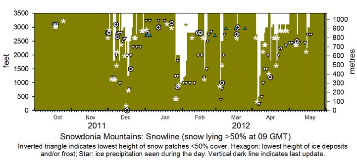
October Patchy snow pellets and snow were lying on Cairngorm Mountain on the 7th. Snow was falling on Ben Nevis and Glencoe Mountain on the afternoon of the 17th, but did not last many days. After passage of a cold front in the afternoon temperatures on the morning of 18th were low enough for ice precipitation on the Snowdonia summits; a sprinkling was seen on Carnedd Llewelyn and C. Dafydd by noon. Mike Peacock reported frequent heavy hail showers on the Migneint through the day. Frequent wintry showers continued across the Snowdonia range on the 19th; Alex Turner reported that the ECN's camera had recorded melting snow on Yr Wyddfa. Ice precipitation was seen on the north-west shoulder of C. Llewelyn in the afternoon of the 25th. There was no snow lying seen at 0900 GMT in the month.
November With above average continuing into November it was good to see that snow had fallen in the far North of Lapland on the 2nd. With the weather keeping mild there was little in the way of snow in Britain. I spotted a sprinkling of 'white precipitation' on Ben Nevis and Cairngorm on the 22nd around noon, but it soon disappeared. There was light ice precipitation including snow on Ben Nevis and Cairngorm on the 25th, nothing was seen on the Carneddau and Yr Wyddfa. Patchy light hail and snow remained on Ben Nevis and Cairngorm on the 26 - 30th December There was slight ice precipitation seen on Carnedd Llewelyn and cliffs eastward at 0900 GMT on the 1st (Snowdon was obscured in cloud). Overnight light snow had fallen on Ben Nevis and Cairngorm. During the afternoon cloud lifted from all summits that were clear of any snow. Later John Williams reported temperatures were low enough for snow to fall after sunset on the highest mountains. Light snow cover from late afternoon showers was seen at dusk above about 2,500 ft on the Carneddau (mainly), Glyders, Carnedd y Filiast and the Elidirs. Snowdon was obscured by cloud. Overnight more snow fell on Ben Nevis and Cairngorm. On the 2nd at 1030 GMT a little fresh snow was seen just under a variable cloudbase on the Carneddau and Tryfan at 2800 ft. Wintry showers at times across the tops on the 3rd, light to moderate snow showers on the 4th with light snow lying at 1800 ft, as low as 1500 ft centrally on the Carneddau, and 1200 ft near Llyn Ogwen on the morning of the 5th. Further snow showers overnight with similar snow levels maintained on 6th with temperature between -1 and -4C on the summits, there was more precipitation during the morning with some drifting at the higher levels in strong winds around the summits. . On the 7th as temperatures rose overnight the lying snowline had retreated to 2800 ft, but remained lower at 2000 ft on the Carneddau between C. Llewelyn and C. Dafydd. Temperatures continued to rise and was above zero on Snowdon through the night 7/8th thawing most snow leaving icy patches and some deep snow patches on Carnedd Llewelyn. On the 9th much ice especially north-facing slopes and a sprinkling of fresh snow at 2500 ft on the Carneddau and snow patches at 2800 ft. Further showers even at low levels during the day led to slight deposits (snow pellets and snow) at 2000 ft. Snow and snow pellets showers overnight 9/10th with slight snow lying at 1800 ft and as low as 1000 ft at Ogwen with snow patches and ice in places. Patches around the summits remained on the 11th, but there was light snow early on the 12th leaving a thin thawing covering at 2750 ft. Sprinklings of snow at 3000 ft and on some north-facing cliffs with deep patches from old drifts and in gullies on Carnedd Llewelyn remained as low as 2600 ft through to the 14th. On the morning of the 15th snow showers with snow lying at 2000 ft, but thawed up to 2500 ft during the afternoon. Overnight 15/16th further snow pellet (soft hail) and snow showers and light lying snow at 2500 ft on the Carneddau, Glyders and Snowdon, as low as 2000 ft in places with snow pellets on the ground down to sea level in places.. On the 17th there was deep snow in places above 2500 ft, some on icy slopes (avalanches were reported particularly on E-facing slopes and in a gully under Y Garn where a man died) otherwise light snow falling as low as 1250 ft. Moderate snow falls continued above 2500 ft on the 18th with snow falling as low as 800 ft in the morning. On the 19th there was broken snow as low as 1500 ft in places that reduced considerable in heavy rain during the day. By the 20th the snowline had risen to around 2700 ft on the Carneddau, but was as low as 2000 ft in places. As temperatures on the summits rose to 5/7C thawing continued, on the 22nd broken snow remained above 1800 ft with some deep snow patches in gullies as low as 2300 ft. A slight covering of fresh snow was at 2750 ft on the N-facing slopes of the Carneddau at 09 GMT on the 24th with deep snow persistent in gullies as low as 2300 ft remaining until the 29th. Some snow patches, persisted on cliffs near Foel-goch about 2700 ft, until the end of the month. January Little snow was present on the 1st, mostly small patches on some SE-facing cliffs Foel-goch and some remnants from showers of ice precipitation around the highest summits on the 3rd. Patches were seen on cliffs near Foel-goch until the 5th and were surviving near Garnedd Ugain at 3250 ft on the 17th. On the 23rd Mike Peacock reported 'whiteness' on the Main Cliff on Glyder Fach at 1040 GMT and intense hail showers on Migneint between 1130 & 1200 GMT. After warm sector air and rain on the 25th a cold front overnight and following shower trough on the morning of the 26th brought light to moderate falls of snow as low as 1250 ft in places. Further snow showers throughout the day on the 27th with snow lying at 1800 ft on the Carneddau and more generally around 2000 ft. On the 28th there was light snow lying at 2000 ft and as low as 2250 ft near Cwm Idwal and elsewhere. With temperature on the summits around -5C there were moderate amounts lying in places over 2500 ft. Precipitation fell most of the day in North Wales and above 800 ft was snow. Moderate amounts accumulated on the mountains and there was some drifting with unstable slopes developing in 'white out' conditions. On the 30th snow was lying as low as 1000 ft in many places, with deep snow on some slopes and gullies, these conditions were similar on the 31st when temperatures on the summits were between -9C and -5C. February On the 1st snow was lying thinly at 1000 ft, but at higher levels level snow 3-5 cm and unstably deep on some slopes and gullies. Low temperatures persisted on the 2nd, on Snowdon summit -13C at 0900 GMT. Little change in the snowline, generally at 1200 ft central Carneddau, but thinner due to sublimation in the sunny weather. On the 3rd the snowline had crept up to 1250 ft, but there was some at 1000 ft with ice in many places. With the high pressure losing ground to an Icelandic low, fronts moved in from the west with rising temperatures on the morning of the 4th. Precipitation at low levels was of rain, but snow continued to fall on the summits. On the 5th most snow at low levels had melted, but there were large patches at 2500 ft and snow on the summits where temperatures were still in the range -4C to -1C at 0900 GMT. In succeeding days snow remained on most summits over 2800 ft with numerous patches as low as 1000 ft seen on the 10th . By the 14th there was broken snow around the summits with frequent snow patches, some large, as low as 1000 ft. Extensive snow patches on N-facing slopes of Garnedd Ugain. Snow patches persisting on the 16th as low as 1000 ft. Snow pellets at lower levels, and snow over 2000 ft fell during the morning of the 18th after passage of a cold front and was seen lying at 2500 ft during the afternoon. On the 19th there was a thin covering at remaining at 1500 ft on the central Carneddau, and as low as 1200 ft near Ogwen, with more on lying on western mountains. There was thin lying snow at 2500 ft, moderate amounts over 2900 ft, with some at 1500 ft in places on the morning of the 20th, with thawing taking place during the day at all levels. By the 22/23rd rising temperatures had sadly melted most snow, but small patches persisted at 2750 ft (23rd) and 2850 ft (25th) on the Carneddau, and 2750 ft on NE-facing cliff at Foel-goch on Snowdon (28th).
March The month began with no snow lying on the mountains. Overnight 3/4th snow fell as low as 400 ft in places and was lying generally on the Carneddau between 800 and 1000 ft. Snow persisted on the 5th with fresh snow showers on the 6th snow was at 2500 ft in afternoon sunshine. Temperatures rose overnight 6/7th and with rain falling there was little if any snow left by morning. Precipitation during the morning of the 17th left light snow pellets and snow on the mountains above 2500 ft and on the 18th was lying on N-facing slopes of the Carneddau and SW-aspect of Yr Wyddfa at 09 GMT. There was a little left on summits around 3000 ft on the 19th, but a few small patches persisted on Carnedd Llewelyn , including Y Ffoes Ddyfn, until near the end of the month.. April Snow was absent on N-facing slopes at the beginning of the month, snow fell on the morning of the 3rd and a sprinkling was lying as low as 2750 ft with a moderate amount on flatter top of the Carneddau. Further continuous precipitation overnight 3/4th and during the morning with snow as low as 250 ft in places in Conwy and Gwynedd with moderate accumulations above 1000 ft , and heavy (>15 cm) above 2500 ft where in 'blizzard conditions' there was drifting in strong to gale-force NE'ly winds. There was snow lying in Llanberis, Llandegai and Bethesda. On the 5th there was little change in levels on N-facing slopes and in bright sunshine the mountains looked stunning across the range in clear visibility. Large snow patches (old drifts) were persisting as low as 250 ft on the 6th with large areas of broken snow at 1250 ft. On the 7/8th patches remained at 500 ft with snow lying >50% above 2500 ft. On the morning of the 10th lowest patches were at 1500 ft and with fresh snow on the summits snow was lying above 2800 ft rising by the 11th to 3000 ft. On the 13/14th there were frequent large patches remaining around 2500 - 2800 ft, lowest smaller ones were at 2000 ft, but insufficient to record lying snow cover. Fresh snow fell late in the day of the 14th as low as 2000 ft and was lying at 1800 ft some as low as 1200 ft on the morning of the 15th. Slight snow persisted on 16/17th around some summits, particularly C. Gwellian and C. Llewelyn, topped up by occasional sprinklings on the 18/19th. Gully snow patches, old cornices and some large old drifted patches were persisting on the 19th, some (small) as low as 2000 ft. Fresh snow fell during the morning of the 20th and was seen lying at 1800 ft on the Carneddau at 1030 GMT when cloud lifted. By the 21st snow at low levels had disappeared leaving patches of old snow persisting from 2000 ft upwards and light snow above 2800 ft around the summits. Mostly broken snow in old patches on the summits on the afternoon of the 22nd, some large patches remaining in gullies, height of lowest being around 2250 ft.
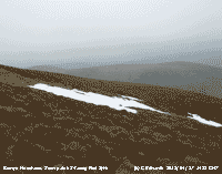
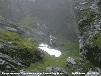
Geraint Edwards reported that on the 27th there were 6 or 7 snow patches and small drifts remaining on the Berwyn Mountains including S-facing Foel Syth (photo right) and in a deep hole at 2000 ft on the eastern side of Craig Berwyn. May
¤
You can view the snowline histograms for previous years here: You can view complete snowline reports for previous years here:
NotesObservations were made as near to 0900 GMT as possible. I have a good view from Llansadwrn, weather permitting, across the Menai Strait towards the Snowdonia Mountains. I can see the northern slopes of the mountain range from Moel Eilio (west of Snowdon), Snowdon summits (Yr Wyddfa and Crib Goch), the Carneddau and to Foel-fras and Drum on the eastern end near the Conwy Valley. With the aid of binoculars I made daily records that include any ice precipitation observed, the lowest altitude of snow lying (>50% cover) and any patchy cover (<50%).
|


