|
Snowdonia Mountains Winter Season 2021/22
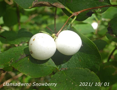
October 2021 Snowberry (left) has white berries well-developed so is it not time for some snow on the mountains? The small rather insignificant pink flowers in summer produce white round and fleshy berries in the autumn. They were particularly lush this year, but was no indication of a good snow season as snowfall was poor...
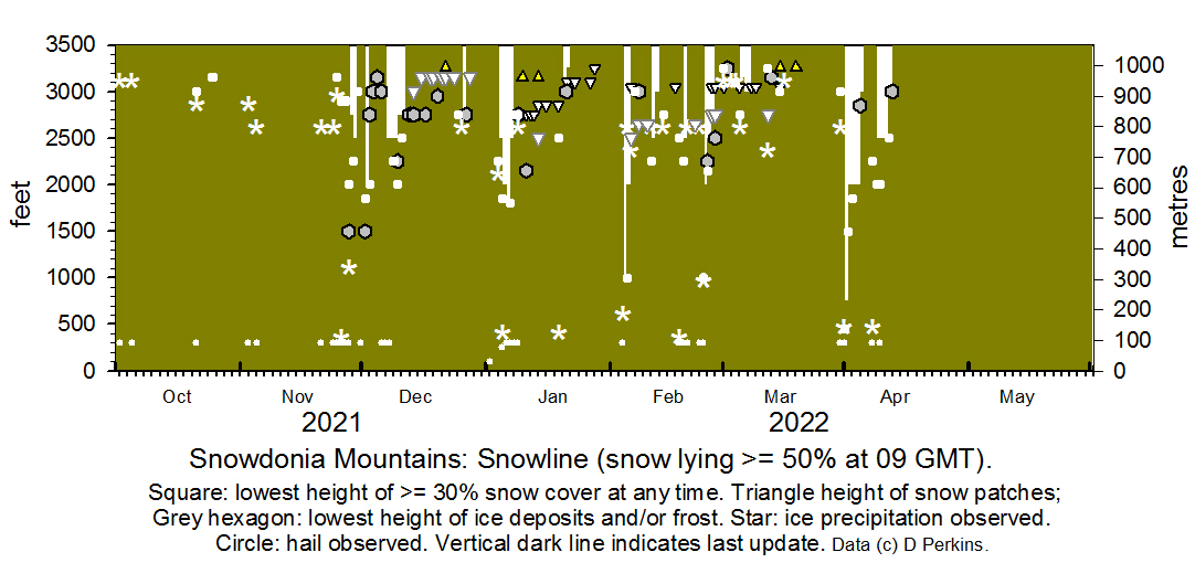
November On the 21st the weather had turned colder and there were showers of hail across Anglesey and the mountains early in the day. A sprinkling of snow was seen on Yr Wyddfa in the afternoon. Further wintry showers 24/25th with some snow on Yr Wyddfa and Garnedd Ugain on the afternoon of the 25th. Wintry showers on the 26th with increasing N'ly wind, the Met Office issued an Amber warning for severe wind affecting Anglesey and Snowdonia 26/27th. There was slight snow scattered on the summits of the Carneddau and Yr Wyddfa in the afternoon of the 27th. Further ice precipitation fell overnight 27/28th leaving a light covering of snow lying at 0900 GMT on the 28th above 2750 ft with some at 2000 ft and sprinklings as low as 1500 ft in places on the Carneddau and summits around Yr Wyddfa.December
Snow was present on the 1st and light snow had fallen on the 2nd and was lying on the Carneddau Mountains at 2000 ft and around Yr Wyddfa with sprinklings as low as 1850 ft. Small patches and pockets of ice remained above 3000 ft. On the 7th and 8th snow was lying above 2500 ft and on the 9th above 2750 ft with 30% cover at 2250 ft on the slopes of the Carneddau. By the 13th frequent small patches of snow and pockets of ice remained including small cornices in places. Frequent pockets of ice were persisting on C. Llewelyn and Dafydd with small cornices on Y Garn on 20/21st, as well patches of snow around Yr Wyddfa above 3100 ft and a patch on Garnedd Ugain at 3250 ft on the 22nd. On the 26th slight fresh snow had fallen and was lying above 2750 ft on the Carneddau and Y Garn at 3250 ft small patches persisting in a few places including around Yr Wyddfa. ..
January 2022 The year began with no signs of snow on the mountains until the 4th when sprinklings appeared on Y Garn above 2500 ft and a covering on the Carneddau above 2500 ft with some as low as 2250 ft. On the 5th further light snow had fallen on the Carneddau lying above 2000 ft with 30% as low as 1850 ft. In the afternoon a covering was seen on Glyder Fawr and Yr Wyddfa above 2000 ft. On the 6th light snow was lying above 1800 ft and on the 7th at 2500 ft on the Carneddau and 1800 ft on Yr Wyddfa. On the 12th gully snow and snow patches and cornices were persisting in places. A few small parches and cornices persisted until the last melted on the 30th. February After an absence since the end of January snow returned on the morning of 4th and was lying at 1000 ft on the Carneddau, with a good covering on Yr Wyddfa and Moel Eilio. A little snow fell on summits on afternoon of the 14th that remained on the 15th. Snow fell again on the 18th some remaining on the 19th. Snow fell on the 24th as low as 1000 ft again persisting on the 25th. Snow patches persisted to the end of the month. March March began with almost no snow remaining on the mountains. Snow fell overnight 4/5th and was lying around summits on the 5th with some remaining on Yr Wyddfa and G Ugain on the 6th. A little fell again on the 12th and 15th neither lasting long. The 30th saw snow again and lying as low as 1000 ft around Ogwen and elsewhere on the 31st with some as low as 450 ft on the northern slopes of the Carneddau and some summits on Llyn. April Light snow was lying above 2000 ft on the 1st. Snow was seen on the 8th this persisted until the 12th.
NotesObservations were made as near to 0900 GMT as possible. There is a good view from Llansadwrn, weather permitting, across the Menai Strait towards the Snowdonia Mountains. The northern slopes of the mountain range from Moel Eilio (west of Snowdon), Snowdon summits (Yr Wyddfa and Crib Goch), the Glyderau and Carneddau to Foel-fras and Drum to the east of the range near the Conwy Valley can be seen. Daily records are made including any ice precipitation observed, the lowest altitude of snow lying at ( >= 50% cover), at ( >= 30% cover) and snow patches.
|


