|

Times are GMT (UTC, Z). Observations at this station [ ] are 24-h 09-09 GMT, some others { } occasionally refer to other 24-h periods, extremes (first indications) are given in bold and are usually 21-21 GMT. When averages are referred to (.) compares with the last decade and [.] with the new 30-y climatological average [1981 - 2010]. All data are subject to verification and amendment.
January 2016
A clearing sky on the morning of the 6th with minima 5.0C and 1.0C on the grass. The breeze was N'ly and visibility was good though misty (temperature 5.3C dewpoint 4.8C and RH 97%). Sunshine from time to time during the day before cloud encroached from the W later in the afternoon with 'watery looking' weak sunshine. The maximum today was 10.1C with Milford Haven on 10.6C and Scilly having 11.3C. Anglesey missed out again on the heavy rainfall that fell in Snowdonia [Capel Curig 22.0 mm Lake Vyrnwy 21.8 mm] just [0.8 mm] falling here.
There was a ground frost -2.0C before further rain from 07 GMT on the 9th brought the total up to [14.5 mm] at 0900 GMT. Rain had turned showery and again the garden and fields were puddled and Henllys lane remained flooded and close. Rain eased later with some glimpses of sunshine before further slight rain around 15 GMT rainfall [13.8 mm]. Snow overnight on the mountains and with near gale force winds some drifting had occurred. Snow was lying at 2000 ft and 30% cover as low as 1250 ft in places on the morning of the 10th, Moel Eilio had snow at 1800 ft and there were sprinklings on some summits in Llyn and on Cadair Idris. The 11th began brightly with a clearing sky after rain in the night from midnight to 0300 GMT [2.6 mm]. This had fallen as snow on the mountaintops that were capped with cloud. The temperature had fallen and at 0900 GMT when calm was 1.5C and on the grass -3.0C and still falling as a result moisture was freezing rapidly. Ice formed on untreated surfaces and there were some road accidents were reported including on the A5025 at Pentraeth which is a frost-hollow. The grass minimum did go down a little further after 0900 GMT to -3.5C. In all nearly 70 ice related crashes were reported in North Wales (BBC Wales website). A fine sunny morning with very good visibility. Cloudier from midday with showers one at 1220 GMT looked 'sleety' but contained some very small ice pellets finely marking the hail pad; a similar shower at 1800 GMT. At this time the wind was cyclonic veering round the compass returning SW'ly. [Max 7.7C Min 1.4C Pptn 3.1 mm]. A showery morning on the 12th, some moderate to heavy with very small ice pellets included. Snow on the mountains lying around 2650 ft. Mostly cloudy with a few glimpses of sunshine. [Max 6.2 Min 1.2 Pptn 2.1 mm]. With some clear sky overnight the air minimum on the 13th was 0.7C and was the coldest since 27 April 2015 (-0.1C) the last recorded air frost On the grass it went down to -4.9C and the soil surface was frozen, the lowest since 3 February (-7.6C). Already beginning to cloud over at 0900 GMT the morning had glimpses of sunshine. There was a shower of rain small ice pellets at 1245 GMT and another at 1933 GMT. [Max 6.0C Min 0.7C Pptn 14.0 mm].
There was moderate showery precipitation, rain, small hail and sleet, from midnight on the 14th that accumulated 14.0 mm. A mostly cloudy morning to begin with then brightened up to sunshine for a while before turning cloudier by afternoon. Showers, developing off the Irish Sea, of conical snow pellets, some 5 mm, or more, fell around 1630 GMT then more snow pellets and snow showers in the evening covered cold surfaces to a depth of 1 cm by 2200 GMT. Gritters were out; roads affected by snow and ice included the Horseshoe Pass, Crimea Pass and around Machynleth. The Met Office had issued a yellow warning of snow and ice for Wales. [Max 5.3 Min 1.8C Pptn 3.8 mm]. On the morning of the 15th there was plenty of snow on the mountains, the temperature on Snowdon was -8C, lying at 850 ft with some at 450 ft in places, but there were just remnants of mainly snow pellets on the ground in Llansadwrn. Wintry showers continued to cross the mountain range adding to the already moderate to deep snow. Bright with sunny spells, cloudier by noon with the afternoon mostly cloudy with wintry showers later. [Max 6.4C Min 1.0C Pptn 1.5C]. The 16th continued cold the temperature at 0900 GMT 2.0C up from a minimum of 0.7C. Grass frost was -3.6C. The temperature on Snowdon was -6C. Air frost was recorded at Valley -0.9C; Mona -1.9C; Rhyl -0.9C, but not here or in Llanfairfechan (1.1 & 1.9C), Aberdaron (3.3C) and Aberporth (1.9C). The day was dull and sunless with showers of rain at 1307 GMT and 1830 GMT. [Max 6.0C Min 0.7C Pptn 3.9 mm]. On the 17th despite being overcast there was low mist on the fields and Cefni Marsh at 08 GMT. There was an intermittent very light SE'ly breeze through the day that again was sunless. Slight showers in evening and night. The National Park Warden reported deep wet snow on Snowdon and had observed debris from a small full depth avalanche (about 10m by 15m by 60cm deep) adjacent to the PYG track between Bwlch Moch and the junction with the Miners' track. (MetO Snowdonia Mountain forecast web page accessed 18 Jan) [Max 6.8C Min 2.0C Grass 0.2C Rain 0.3 mm]. A bright early morning on the 23rd with a few glimpses of sunshine under breaking cloud, but this was all as the cloud thickened and it was soon overcast and dull. Pressure was 1025 mb and with pressure low (965 mb) to the N and high (1035 mb) to the S we were in a moderate SW airflow. There was intermittent rain from 1530 GMT [Max 11.7 Min 7.6C Rain 2.6 mm]. At 0130 GMT the temperature recorded at Gorwel Heights was 13.9C (87% RH). The 24th was another overcast and dull day with drizzle and slight rain not amounting to a great volume, but wet if out in it. Continuing mild the temperature at 0900 GMT 11.0C with 99% RH. After midnight there was another Föhn-like wind event in Llanfairfechan and to a lesser extent in Llansadwrn. The temperature at Gorwel Heights rose to 16.8C (63% RH) at 0059 GMT and at Gorddinog to 16.6C around 0319 GMT (Stevenson screen). These remarkable night-time maximum temperatures exceeded a previously held record of 14.4C on this date at Wisley in 1937 and Bramham (W Yorks) in 1962 (TORRO). The MetO reported UK max to 21 GMT on the 24th was 16.5C at Achnagart and to 21 GMT on the 25th was Lossiemouth 15.6C. In Llansadwrn the effect, though present, was not as marked with a maximum of 14.2C at 0330 GMT highest of the month did not exceed the 16.5C recorded on 10 January 1998 ranking H2 at this station since 1979. [Max 14.2C Min 8.6C Rain 0.6 mm].
The 25th was a very rough day, cloudy and dull and remained so in the sunless day. Wind was again a large factor in the weather already strong to gale force (Gorwel Heights gust 50 mph at 0929 GMT) with ragged low cloud; rain was slight or with drizzle at times, visibility was poor. [Max 13.2C Min 11.0C Rain 9.5 mm]. On the 26th with another low 979 mb at 0900 GMT tracking N W of Ireland, remnants of N America Jonas snowstorm, brought very strong winds and rain. In Llanfairfechan gusts of 59 mph were recorded around 07 GMT at Gorddinog and Gorwel Heights while Capel Curig reported 82 mph. With moderate rainfall on saturated ground local roads were awash and runoff again flooded Henllys Lane in Beaumaris. The Britannia Bridge was close to HSV's with a 20 mph restriction and this caused congestion in Menai Bridge at the rush hour as vehicles used the Suspension Bridge. The month ended with a mean temperature of 6.5C (+1.3) & [+1.4] of averages, highest since 2007 ranking 7th in station records since 1979. Rainfall was 159.2 mm (149%) & [156%] of averages largest since 2008 and ranking 12th since 1928. A fairly dull month was 77% of average sunshine and 9 sunless days.
February 2016
February 1 - and another dull morning although the sky was brighter looking towards Conwy and it was quite a nice morning with some blue sky in Llandudno. We were in warm sector air, the temperature at 0900 GMT 10.6C (dewpoint 9.4C), but Storm Henry 945 mb at midnight was SSW of Iceland tracking north-east. Pressure here 1007 mb was falling and there was a near gale SW'ly wind gusting to 47 mph and the daily mws was 20.1 mph. Pressure soon started to slowly rise from 1006 mb, the strong wind was sustained through out the day with a 20 mph speed limit on the Britannia Bridge. [Max 11.0C Min 6.7C Rain 0.7 mm]. With the wind moderating overnight there were signs of the sky clearing on the morning of the 2nd and it was fairly bright under thinning cloud. A few glimpses of sunshine and a light show around 1245 GMT with a few spots more in the middle of the afternoon. Breezy at first, much less windy later in the afternoon. After 35 days BT Openreach turned up in force, with 4 vans and a mobile platform, and repaired the broken cable at the church that had kept 5 households without telephone or internet since Storm Frank on 30 December. On the 3rd pressure 1020 mb was rising and with low pressure over the Baltic and high 10451 mb to the SW Atlantic air was being drawn down from the NW. Bright with sunny spells with a maximum of 9.1C. A spell of light rain in the evening from 23 GMT to after midnight [Rain 3.6 mm]. The 4th was a dull and sunless day and starting with misty low cloud and drizzle. This petered out although there were some spots of rain in the evening about 21 GMT. [Max 9.6C Min 3.8C Rain 1.8 mm]. Intermittent rain from 06 GMT on the 5th and slight rain and drizzle under leaden skies at 0900 GMT. Visibility was poor and it was breezy strengthening to near gale force in the afternoon in warm sector air until moderate to heavy rain falling from 1500 GMT to 2030 GMT on passage of a cold front. [Max 9.4C Min 7.7C Rain 15.5 mm]. Similar on the 6th beginning dull with slight drizzle and with pressure falling quickly as low 965 mb Shannon tracked N during the afternoon. Lowest pressure was 978 mb at 1625 GMT with moderate to heavy rain (highest 11 mm/h) and with gusty wind 31 mph at 1641 GMT on a cold front. The day was sunless. [Max 9.7C Min 3.3C Rain 4.1 mm]. The 7th began brightly with thrushes singing and greater spotted woodpeckers drumming at 0900 GMT. There was a moderate SW'ly breeze, pressure 987 mb rising with low 961 mb filling near the Western Isles. Continuing breezy there were some sunny spells before moderate rain from 1500 GMT to 1700 GMT as the temperature dropped to 5C turning showery in the evening as the temperature rose to the maximum of 9.1C at 1915 GMT. It was cold enough for snow on the mountains as low as 2250 ft in the afternoon with moderate amounts seen on Carnedd Llewelyn and C, Dafydd. Windy at Gorwel Heights with a gust of 60 mph recorded at 1810 GMT. [Max 9.1C Min 3.9C Rain 8.1 mm]. Pressure had steadied on 972 mb after a low 971 mb at 0730 GMT on the 8th this was named Storm Imogen that was 961 mb W of Ireland bringing severe force winds to South Wales and along Channel coasts from Cornwall to Kent; many properties lost power supplies. It was fairly quiet here with a peak gust of 41 mph and a daily mws of 16.3 mph. A sunless day with a few slight showers of rain and light rain from 11 to 1330 GMT. [Max 10.6 Min 4.5C Rain 2.7 mm]. A brighter morning on the 9th, but cool being 3.7C at 0900 GMT dewpoint 1.1C with a small chance of seeing some ice precipitation. On Snowdon the temperature was around -1C to -5C with some snow showers. Pressure 984 mb with low 979 mb over Belgium and there was open celled marine convection to the NW. Towering cumuli were seen during the morning with some glimpses of sunshine. Breezy around noon with showers of sleet at low levels and snow on the mountains moving in off the Irish Sea; there was a bright rainbow about 1445 GMT over Treffos, Llansadwrn. The temperature dropped to the minimum of 3.1C at 1800 GMT before rising again during the evening. [Max 5.2C Min 3.1C Pptn 3.7 mm]. Showery precipitation after midnight then a bright morning on the 10th. Towering cumuli in the vicinity again in a light NW'ly breeze. The temperature was 2.5C with dewpoint 2.0C at 0900 GMT. Another ground frost again with slight ice still on the grass minimum thermometer -1.8C. Pressure 998 mb was rising quickly with low 977 mb over the Baltic. Sunny spells with the sky clearing later in the afternoon and a dry 24-h. [Max 8.6C Min 2.1C nil Pptn]. After a mostly clear night there was silver frost on the grass with a minimum of -3.7C on the morning of the 11th. Cumulus clouds and a cumulonimbus spotted to the W. Showery sleety precipitation in the middle of the day and again during the evening. [Max 5.8C Min 1.6C Pptn 7.9 mm].
A fine, but mostly cloudy morning on the 12th with a light SE'ly breeze here, but in Llanfairfechan windier with a moderate breeze. The jetstream at present is well S of the UK; low 987 mb was over the Celtic Sea with pressure here steady on 994 mb. Just a few glimpses of sunshine through the dry day. [Max 7.4C Min 2.4C trace of dew]. Dry again over night and mostly cloudy at 0900 GMT on the 13th with a light E'ly breeze. Pressure 988 mb was rising with a low 973 mb at the western entrance to the English Channel. Sunny especially in the west of Anglesey. [Max 6.0C Min 3.2C nil Pptn]. Similar on the 14th after an overnight minimum of 1.5C and a light E'ly breeze the temperature rising to 5.5C in sunny spells and another dry day. Continuing dry on the 15th in a moderate NE'ly breeze. Very good visibility, and mostly sunny, with fine views of the snow on mountaintops in the afternoon. [Max 5.9C Min 2.2C nil Pptn] . The first 15-d of the month had 49.2 mm precipitation (72%) & [63%] of the monthly averages while the mean temperature 5.7C was (+0.3) & [+0.5] of averages. Overnight the air temperature fell to -1.2C (at 2139 GMT) to give the first air frost of the winter and 5.8h of frost. The grass minimum had fallen to -6.8C, but there was no white frost. The 16th began mostly cloudy with a red sky at 0730 GMT and a strengthening force 5 S'ly wind reached near gale force around noon. A frosty night 5.8h of frost, minimum -1.2C, with the grass minimum down to -6.8C. Pressure 1029 mb was falling with low 981 mb W of Ireland. Dull, windy with slight showers of rain, gusty wind 40 mph at 1352 GMT. During the evening warm sector air the temperature rising to 7.5C before the rain just after midnight. [Max 7.5C Min -1.2C Rain 11.6 mm]. Light to moderate rain with very heavy rain at 0230 GMT, with rapidly moderating wind as the cold front passed over, accumulated 11.6 mm by morning. At 0900 GMT on the 17th pressure 1013 mb was rising from a low of 1011 mb at 0620 GMT. It was still raining and there was standing water again. The temperature 4.7C was still falling and visibility was moderate the wind light NW'ly. It was cold enough for fresh snow to settle above 1800 ft on the Snowdonia Mountains. Drizzly rain in the afternoon at first then clearing sky and with temperatures falling quickly at dusk a frosty night. [5.2C Min 3.9C Pptn 3.8 mm] A cold night on the 18th with air minimum of -0.8C with 7.3h of frost. There has been some small hail with remnants still on the ground. The grass was white with frost, with a minimum of -6.8C again, and the fields had a moderate covering, water was frozen but concrete was not icy. The day became mostly sunny and with good slightly hazy visibility the mountaintops looked white with snow. [Max 7.3C Min -0.8C Pptn 0.2 mm]. The 19th began overcast and dull with light rain beginning just before 0900 GMT. Pressure 1012 mb was falling with low 961 mb over the Denmark Strait while pressure was high 1042 mb over the Azores. A moderate S'ly breeze and the day kept dull and sunless. [Max 8.9C Min 1.7C Pptn 1.3 mm] And, another dull sunless day on the 20th after a dry night and mild night spots of rain at 0900 GMT. Pressure was on 1007 mb with low Iceland 964 mb and a frontal wave over the Bristol Channel and Cardigan Bay. The spots turned to light rain and continued, at times moderate even heavy rain (10 mm/h at 1150 GMT), through the day. A moderate SW'ly breeze. Wet in Snowdonia with [38.8 mm] falling in Capel Curig. [Max 10.0C Min 5.5C Rain 14.4 mm Duration 14.0 h]. Much the same on the 21st, dull and windy. It was dry at first then a spell of light rain from 1630 to 2000 GMT. The 3rd consecutive sunless day. [Max 10.4C Min 6.8C Rain 2.6C]
The month ended with a mean temperature of 5.4C (-0.1) & [+0.1] of averages, highest since 2004. Rainfall was 107.7 mm (158%) & [137%] of averages largest since 2004 and ranking 23 since 1928. A near average month for sunshine with 9 sunless days. It had been the warmest and wettest winter (Dec - Feb) on record (see monthly report).
March 2016
The first 10-days of the month had a mean temperature of 4.8C (-1.8) & [-2.1] of averages; the first 15-days were a little warmer the mean 6.0C (-0.7) & [-1.0]. Precipitation 15-days 25.0 mm (36%) & [31%] of average. A mostly cloudy morning on the 16th with mist lying in the Menai Straits and only moderate visibility. Pressure was 1034 mb with high 1039 mb over the S Norwegian Sea and a cold front East Anglia to the Isle of Wight.. Soon brighter with the cloud dissolving and there was a sunny afternoon. [Max 10.8C Min 4.5C nil Pptn]. With some clear sky overnight on the 17th and little wind there was a ground frost of -4.5C, lowest of the month. Air temperature had kept above freezing at 0.4C here, but Mona reported at air frost of -1.6C. A sunny day with 11.0h reported at Valley. [Max 10.1C nil Pptn]. Another ground frost of -2.8C on the 18th that at dawn was clear then turning cloudier as cloud/ fog encroached from the sea. Valley reported freezing fog at 0550 GMT. Much of Wales south of here was sunny and warm with 14.1C recorded in Porthmadog, here the best we could do was 6.8C. The cloud dispersed a little around 16 GMT giving a little weak sunshine at times. [Max 6.8C Min 1.8C nil Pptn]. The 19th was a dull overcast and sunless day. Pressure continued steady on 1030 mb with Atlantic high-pressure to the NE 1034 mb. Remnant frontal cloud persisted over Anglesey and Wales with a little dispersion late afternoon, but no sunshine was seen. As the sky cleared in the during the evening the temperature went down to 3.7C before rising again as more cloud encroached. [Max 6.9C Min 4.8C nil Pptn]. More anticyclonic gloom on the morning of the 20th, but there was a little clearance in the afternoon when the sun appeared and it was for a while a little warmer. [Max 10.8C Min 3.7C trace of dew]. Little change on the 21st after an overnight ground frost -3.0C. A dull and sunless day [Max 8.7C Min 1.4C Grass -3.0C nil Pptn]. Another dull and sunless day on the 22nd with high-pressure 1022 mb over the Severn Estuary/ Bristol Channel (1019 mb here) with trapped air pollutants in the high going nowhere there was thick haze and moderate visibility. After 1100 GMT there was low solar radiation (total in the day 3.64 MJ m -2) making the afternoon darkest of the month at 61 W m -2. [Max 9.1C Min 4.3C Grass -1.1C nil Pptn]. Rainfall to date this month has been 26.0 mm (36%) & [31%] of the total for March. The 23rd began again very dull with poor visibility, but the afternoon did brighten up and there was a little sunshine. It was cloudy again by evening as a cold front bringing some rain was encroaching off the Irish Sea. [Max 9.1C Min 4.3C Grass 4.8C Pptn 2.3 mm]. The temperature had kept up to 7.7C overnight, but before 06 GMT on the 24th had fallen a little with some light rain falling. At 0900 GMT the temperature had recovered to 7.5C. Visibility was poor in light to moderate rain; light rain and drizzle continued at times through the morning and into the afternoon enough to form some small pools of standing water around the garden. Sunless with the lowest solar radiation of the month 2.88 MJ m -2
. [Max 8.9C Min 6.6C Pptn 4.0 mm]. The sky cleared after 03 GMT in the night so that on the morning of the 25th the sky had just 3 oktas of cover. It was a fine and sunny morning although visibility was moderate in smoke haze. Pressure 1014 mb was rising in a transient ridge from an Iberian-high 1027 mb. The afternoon was sunny, but it was breezy gusting to 31 mph at 1535 GMT. [Max 11.8C Min 2.5C Grass -1.3C trace Pptn]. It was back to an overcast sky after a little early morning sunshine on the 26th with slight rain commencing 20 minutes before 0900 GMT. Visibility was poor and there was a near-gale force S'ly wind. Pressure had fallen to 994 mb and was still falling with a low 983 mb over Shannon and a frontal-wave over Cardigan Bay. There was a burst of precipitation including ice pellets on a cold front just after 1400 GMT (27 mm/h 1408z) GMT was highest of the month. During the evening the wind was gusting at 38 mph. [Max 11.3C Min 7.3C Pptn 16.6 mm]. The 27th began brightly with pressure on 991 mb at 0900 GMT (990.5 mb reached at 0819 GMT) and a moderate to strong S'ly wind. Towering cumulus clouds were in the vicinity and we were having frequent blustery a recent one at 0824 GMT with a 30 mph gust of wind included 4 - 6 mm ice pellets. Low 978 mb was just N of Shannon with a shower front over Wales. Frequent showers continued. [Max 8.3C Min 5.2C Pptn 4.8 mm] At 1545 GMT there was a sudden onset of lightning, and almost simultaneous overhead thunder, that produced a bright white light and loud discharge inside the weather house knocking out the station's internet modem. The above ground electricity supply went off, but was soon restored. This was followed by another cloud to ground lightning strike seen to the east of the station, again the electricity supply was off for some seconds then restored, and a shower of ice pellets at a melting rate of 1.6 mm per hour in the 10 mins up to 1600 GMT (the AWS gauge heater was not on). This was followed at 1715 GMT was a shower of 8 to 11 mm hail (code 6) heavily indented the hail-pad and covered the ground with a melting rate of 5.6 mm per hour by 1720 GMT and 3.6 mm per hour by 1730 GMT. Several households reported damage of equipment and on the Monday morning the Beaumaris Post Office computers were still offline at 10 am due, the Postmaster said, to the electrical surge, and no financial transactions could be effected until later. The weather station AWS was back online later in the day using a back-up modem. On the 28th around 0445 GMT there had been there had been a shower with a light fall of ice pellets. The sky was overcast in the morning with a light W'ly breeze and by afternoon it had cleared giving a lot of sunshine. There was light snow on the mountains above 2250 ft. [Max 10.1C Min 3.9C Pptn 1.6 mm].
The month ended on a wet and stormy note with a drier than average rainfall of 56.6 mm(79%) & [66%], lowest since 2012. Another cool month with a mean temperature 6.3C (-0.3) & [-0.6] lowest since 2013. .
April 2016
April 1 - and a dull sunless day to start the month. Slight rain and drizzle most of the day on a blustery moderating S'ly breeze with rain turning heavier during the evening. Pressure was on 1013 mb with a low 966 mb S of Greenland with associated warm fronts over the Irish Sea and W of Ireland. [Max 9.5C Min 3.2C Rain 15.8 mm]. Rain continued after midnight at times moderate to heavy with 15.8 mm measured on the 2nd at 0900 GMT. Overcast with a warm front over the Irish Sea and remaining sunless. With the soil still near saturation point there were pools of standing water with several large ones on the old cricket field. Sl rain and or drizzle again most of the day. [Max 9.8C Min 7.3C Rain 3.1 mm]. The 3rd again began overcast and dull, but with a light SE'ly breeze brightened during the morning with a few glimpses of sunshine and slight showers. There were large areas of patch rain over the Irish Sea with pressure steady on 1004 mb. During the evening from 20 GMT there was moderate to heavy rain. [Max 12.3C Min 4.8C Rain 14.6 mm]. Light rain after midnight petered out around 0430 GMT, by the morning of the 4th when 14.6 mm had been measured there was standing water again in places. There was a break in the cloud sheet and there had been a glimpse of sunshine, visibility was very good and clear, but it did not last with cloud thickening and spots of rain at times during the day. A bright morning on the 26th with a very chilly NE'ly wind. Visibility was very good and there was a sprinkling of snow on the tops of Carnedd Llewelyn, Tryfan and the Glyderau, together with persisting snow patches. There had been a fall of snow pellets and a few snow flakes. Pressure 1012 mb was rising with low 993 mb off the coast of the Netherlands. There were towering cumuli over the mountains in the afternoon with snow showers crossing the range at times. Sunny at times in Llansadwrn before we caught a shower of snow pellets and snow flakes under a dark cloud at 1720 GMT and similar at 2215 GMT. [Max 10.5C Min 3.7C Pptn 1.9 mm]. Overnight more snow fell on the mountains and on the morning of the 27th snow was lying at 1750 ft. There was some also at 1000 ft around Llyn Ogwen and as low as 450 ft on the lower slopes of the Carneddau. The Caernarfon Road into Bangor early in the day briefly had a slight covering of ice precipitation. At 0900 GMT the temperature was 6.1C 78% RH with towering cumuli in the vicinity. There was a prolonged snow pellet and snow shower from 1040 to 1100 GMT and a little snow fell in Bangor at 1030 GMT. It was dry with sunny spells in the afternoon, but kept cold. [Max 8.9C Min 1.9 Grass -1.2C Pptn 1.0 mm]. In contrast the 28th began overcast and there was rain from 0850 GMT. The temperature at 0900 GMT was 5.6C risen from overnight minimum of 0.9C and -2.7C on the grass. Pressure was 1011 mb with a deepening low 1004 mb Malin Head and North Channel tracking to Tiree 1000 mb at noon. A dreadful day: a blustery morning with a fresh SW'ly wind, dull with moderately heavy rain and some wet snow pellets and or sleet at 1310 GMT. The lowest maximum of the month [Max 7.2C Min 0.9C Grass -2.7C Pptn 8.7 mm Duration 14 hours]. In compensation the the 29th began brighter with a gentle W'ly breeze and a temperature of 6.5C. Pressure 1007 mb was rising with low 998 mb moved out over the North Sea off Tynemouth and high 1025 mb FitzRoy. Bright with some sunny spells with frequent slight showers of snow pellets or rain becoming warmer through the day. [Max 11.4C Min 1.1C Grass -1.6C Pptn 0.9 mm Duration 3 h].
A sunny morning on the 30th the last day of the month. Pressure 1021 mb was continuing to rise with high 1031 mb FitzRoy and low 1007 mb E North Sea and low 995 mb E of Iceland. Some towering cumuli were seen over the Snowdonia Mountains together with a cumulonimbus cloud. Snow was lying at 2000 ft with 30% cover at 1750 ft. Sunny with very good visibility and 12 h sunshine. Later and overnight cloud encroached. [Max 11.8C Min 1.4C Pptn 1.1 mm]. The month ended rather chilly after the 16th wettest April since 1928 and an above average total of 78.8 mm (146%) & [124%],largest since 2012 that had 100.1 mm. Another cool month with a mean temperature 7.9C (-1.5) & [-1.0] of averages lowest since 2013. After last April's record breaking sunshine this month, though sunny, was the 16th sunniest on the Anglesey record since 1931.
May 2016May 1 - a dull blustery start with intermittent or showery slight rain on a fresh SW'ly breeze. Pressure was on 1021 mb with a complex of fronts over the Irish Sea associated with low 987 mb over Iceland. An Atlantic-high over the Azores was stretching into the Bay of Biscay. It was no better in the Med where a low 1009 mb over Italy would bring along thunderstorms. Here the day continued with rain at times with a strengthening breeze. The AWS at Gorddinog reported a maximum temperature of 15.0C, not up to the 17.5C at Gravesend. [Max 11.3C Min 6.5C Rain 4.8 mm]. The 2nd also began overcast and with dark skies, but it was still cool although the SW'ly breeze was moderating after passage of a weak cold front, gust 37 mph at 0649 GMT, associated with low 973 mb SE Iceland. Pressure was 1014 mb and it was soon brighter with some sunshine in a small clear slot then return to passing convective shower clouds these delivering only light showers of rain. A fine evening [Max 13.6C Min 4.7C Rain 1.0 mm].
After a touch of ground frost -0.2C, a fine, but cool morning on the 3rd with good hazy visibility. A few small snow patches were persisting on Carnedd Llewelyn, Black Ladder cliffs and C. Dafydd. At 0900 GMT with pressure 1024 mb rising under the influence of Biscay high 1030 mb the day was set fair. Along the A5025 the salt tolerant. Danish or early ivy-leaved scurvy grass Cochleria danica was lining the road in long stretches in full flower and seemingly more than ever. [Max 13.4 Min 4.7C Rain nil]. The first 15-days of the month had a mean temperature of 12.5C (+1.0) & [+0.8] of averages. Rainfall was 26.2 mm (33%) & [42%] of averages. On the 16th the sky was overcast and it had been calm overnight, but at 0900 GMT a SW'ly breeze had began. After some dry days the soil surface was dry and on the undisturbed bare met plot some micro-cracking of the surface was seen for the first time this year. The cloud began to break up about 0930 GMT and the day became sunny. [Max 14.6C Min 5.0C Rain nil].A fine sunny morning on the 17th with a moderate to fresh SW'ly breeze. Pressure 1015 mb was falling in a weakening ridge with low 995 mb making inroads S of Iceland and W of Scotland. Frontal cloud was massed over Ireland. In the afternoon cloud encroached and there was rain just before midnight. [Max 16.7C Min 7.7C Rain 6.5 mm]. The month ended with rainfall of 59.2 mm lowest since 2013 (75%) & [95%] of averages. The mean temperature was 12.4C (+0.9) & [+0.7] of averages highest since 2008 ranking 8th since 1979. It was a sunny month at Valley the 250.8 h of sunshine fourth highest in May on the Anglesey record since 1931.
June 2016June 1 - fine and mostly sunny with very good visibility with a cool NNE'ly breeze. Pressure was steady on 1027 mb with high 1037 mb over the Norwegian Sea [Max 16.9C Min 10.3C Rain nil]. On the 2nd the temperature at 0900 GMT was 11.8C and pressure 1025 mb with high 1038 mb S of Iceland. There was a cool NE'ly breeze, a sunny day 11.4 h at Valley [Max 14.8C Min 8.6C rain nil]. Pressure on the 3rd had fallen a little to 1019 mb with a frontal system over SE England and N France, there was extensive flooding in Paris after the Seine broke its banks, rising to 6.10 metres. At Saint-Florent le Vieil La Loire full of silt was rising at a rate of about 1 metre in 24-h and large trees were being washed down the river under the road bridge at a speed of about 100 metres a minute. After a cool night in Llansadwrn at 0900 GMT the temperature was 16.2C and this rose to 18.2C during a fine sunny day with 15.5h sunshine recorded at Valley [Max 18.2C Min 8.3C Rain nil]. Another fine sunny day on the 4th with the temperature rising to 20.4C and 15.5h sunshine at Valley [Max 21.2C Min 11.3C Rain nil]. Yesterday's maximum temperature of 21.2C was at 0900 GMT on the morning of the 5th. Pressure had risen to 1020 mb and it was a warm day with the temperature reaching 25.4C at 1320 GMT and 27.4C at Gorwel Heights at 1350 GMT. Later Gordinnog AWS reported 25.8C at 1710 GMT. [Max 25.4C Min 14.4C Rain nil]. As pressure remained high on 1021 mb on the 6th it was another warm day with very hazy sunshine the temperature rising to 25.6C at 1110 GMT in the morning in a S'ly breeze; 24.0C at Gorwel Heights at 1330 GMT. With an active showery trough over Wales showers of rain broke out between 1210 GMT and 1340 GMT falling at up to between 23 and 38 mm/h; distant thunder was heard around 1200 GMT. A dull sunless day here. At Valley maximum 25.6C; 11.4h sunshine; and 8.0 mm rain [Max 25.6C Min 12.8C Rain 10.8 mm]. On the 7th after a mild night and little wind with a heavy downpour of rain between 0310 and 0320 GMT (that fell at rates up to 53 mm/h). Thunder (METAR TSRA) was reported several times at Valley between 0440 GMT and 1039 GMT. At 0900 GMT the temperature was 17.9C and soon a maximum of 18.1C, thereafter a little cooler and brighter with a slight shower of rain at 1250 GMT otherwise dry. [Max 17.9C Min 15.0C Rain trace]. The 8th began fairly brightly with thin cloud and little or no wind through the day. Sea mist rolled in at times, but cleared leaving a mostly sunny day. Convective clouds developed in the afternoon and there were spots of rain; convective clouds persisted over the Snowdonia Mountains. [Max 21.5C Min 11.7C Rain trace]. At 0900 GMT on the 9th with pressure on 1021 mb the temperature was 18.8C (dewpoint 16.8C) 88% RH. There was a thin covering of cirrus cloud and haze with poor visibility. A warm humid day with variable breezes. [Max 22.1C Min 12.0C Pptn 0.1 mm]. On the 10th pressure had fallen to 1014 mb and the sky was overcast and the day sunless. Overnight the air minimum 14.4C was joint highest of the month. At 0900 GMT the temperature was 18.2C this rising to 20.2C in mid-afternoon. There was showery rain from 1650 GMT (turning heavy at 1700 GMT 43 mm/h) petering out by 1830 GMT. [Max 20.6C Min 14.4C Rain 8.5 mm]. Similar on the 11th being mostly cloudy and dull with pressure 1014 mb continuing to fall slowly. A light E'ly air at 0900 GMT then a S/SW breeze through the day. [Max 19.4C Min 13.5C trace]. Another dull day on the 12th with light rain falling at 0900 GMT. Pressure was 1005 mb and with slack gradients little of no wind at first with a light SW'ly breeze developing with showery rain in the afternoon before becoming brighter with a little sunshine late in the day. [Max 17.4C Min 12.5C Rain 1.1 mm]. At midnight on the 13th low 997 mb was W of Ireland with an occluded front lying over the North Channel, N Wales and E Anglia. With pressure on 1003 mb at 0900 GMT the day was again mostly cloudy, dull and damp. [Max 16.7C Min 12.3C Rain 6.4 mm]. A mostly cloudy morning on the 14th with 5 oktas of 'grey clouds' at 0800 GMT and good, but hazy visibility. Pressure 995 mb had continued to fall with low-pressure centred over Britain with frontal cloud and well developed convective clouds. A heavy shower, falling at rates up to 77 mm/h, occurred just before 0900 GMT. Sunshine was at a premium as pressure fell to 994.1 mb in the afternoon 1640 - 1700 GMT, lowest of the month, in the fifth consecutive dull day with a low solar radiation of 11.19 MJ m -2. A light NE'ly breeze becoming calm later and evening [Max 17.0C Min 12.8C Rain 0.6 mm]. In contrast the 15th began with a mostly clear sky after a cool night air minimum 9.7C and 6.8C on the grass. Pressure was still low 966 mb with little change; the NE'ly breeze picked up again about 06 GMT and continued in the morning becoming intermittent later and calm by evening. A mostly sunny day around Irish Sea coasts and on Anglesey with solar radiation here of 27.93 MJ m -2 and 14.3h of sunshine at Valley; convective clouds persisted over Snowdonia, Wales and elsewhere. [Max 19.1 Min 9.7C Rain 3.5 mm]. The first 15-days of the month had a mean temperature of 15.9C (+1.7) & [+2.0] of averages. Rainfall was 31.0 mm (42%) & [46%] of averages. It has been wetter than average in many parts of the southern Britain. It had been sunny with 116h sunshine recorded at RAF Valley.. On the 16th it was back to overcast skies with showery rain in the early hours and a NNE'ly breeze. Pressure 1003 mb had risen, but pressure was still low 999 mb central England. Frontal cloud lay to the NW, although there were convective clouds in the vicinity, there were a few more spots of rain in the morning, there was some sunshine in between in the afternoon and later as the sky cleared. Breezy mws 3.1 mph. [Max 16.6C Min 11.9C Rain 2.0 mm]. Again the 17th began overcast with frontal cloud over the Irish Sea and there was a cool NE'ly breeze. Pressure 1010 mb had risen, but pressure remained generally low over Europe. The Azores high 1031 mb had extended a ridge W of Ireland. The cloud moved eastward and the day brightened with some sunshine in the afternoon. [Max 15.4C Min 11.4C Rain nil]. At midnight on the 18th pressure W of Ireland reached 1022 mb and here 1016 mb continuing to rise to 1021 mb by 0900 GMT. The sky was overcast at first, but then cleared from the W leaving frontal cloud over SW and SE England. A reasonably sunny afternoon ensued [Max 17.6C Min 10.6C Rain nil]. On the 19th with pressure unchanged on 1021 mb the morning was cloudy with a few spots of rain at 0900 GMT. Frontal cloud over Ireland moved across the Irish Sea and brought light to moderate rain from 1240 GMT, was heaviest around 18 GMT and continuing to 1900 GMT. The SW'ly wind freshened becoming fresh to strong by evening; mws 7.1 mph, highest gust 30 mph both highest of the month. There was more rain after midnight and the total for 24-h from 0900 GMT was 32.4 mm over 14h duration, the wettest day of the month [Max 17.3C Min 10.8C Grass 8.1C Rain 32.4 mm]. On the morning of the 20th the wind had moderated a little, but some large tree branches had fallen across the road from Menai Bridge to Beaumaris. Pressure 1010 mb had fallen with low 982 mb S of Iceland with associated frontal cloud spread across Britain. Dull and overcast with very poor visibility as a warm front moved over the Irish Sea, with moderate cloud/fog increasing during the morning, during showery rain, and persisting in SE Anglesey into the afternoon before clearing when after 16 GMT it was warm in some sunshine [Max 18.3 Min 13.2 C Rain 2.1 mm]. Dull and cloudy at first on the 21st with pressure 1015 mb rising in a weak ridge, yesterday's fronts had crossed the Channel into France. At 0900 GMT the temperature was 14.7C (dewpoint 12.3C) 88% RH and was to rise to 18.1C in the afternoon that was the brightest part of the day in a light SSW'ly breeze [Max 18.1C Min 12.3C Rain nil]. The 22nd began brightly an a little warmer with 15.6C at 0900 GMT. Pressure was on 1017 mb and although frontal cloud lay to the NW it was a mostly sunny day with the temperature rising to 20.0C mid-afternoon. [Max 20.0C Min 13.2C Rain nil]. A weak (cold) front moved across just after midnight on the 23rd with no precipitation the temperature falling to 9.6C, but cloud had more or less cleared SE by morning. With pressure unchanged 1017 mb at 0900 GMT with 2 oktas cloud cover it was a bright day with plenty of hazy sunshine. Cloudier with a little showery rain before midnight [Max 19.2C Min 9.6C Grass 5.4C Rain 1.5 mm]. The 24th began mostly cloudy after some light showers during the early hours, but bright, the clouds dispersed for a while early in the afternoon before returning later [Max 17.7C Min 12.1C Rain trace]. After a calm night on the 25th there were a few spots of rain nearby around 0730 GMT. At 0900 GMT pressure was 1019 mb with a light NE'ly breeze starting to pick up. With frontal cloud over the Irish Sea it was mostly cloudy here with some limited convection developing through the day [Max 17.0C Min 10.7C Grass 7.0C Rain 0.3C]. Another mostly cloudy morning on the 26th as with frontal cloud bands moving eastward the spots of rain at 0900 GMT set the pattern for light rain at times (over 10h duration) during the sunless day [Max 14.9C Min 11.6C Rain 5.4 mm]. On the 27th pressure 1018 mb was rising, the overcast sky at 06 GM was starting to open up at 0900 GMT giving some glimpses of sunshine in the morning. Turning cloudier with convective clouds developing in the afternoon; there was a slight shower of rain at 1630 GMT, otherwise dry. [Max 17.0C Min 11.0C Rain trace]. Low 1007 mb was over the Celtic Sea on the morning of the 28th with pressure here 1018 mb. Dull and overcast, dry at first before showers from 1100 GMT, heavy at 12.20 GMT; 1305 GMT and later. Little in the way of sunshine, but a brighter evening [Max 14.6C Min 10.2C Rain 21.1 mm over 9 hours duration]. Further rain on the 29th from 0540 GMT and still raining heavily at 0900 GMT when 21.1 mm was recorded in the previous 24-h, second largest fall of the month. Pressure 999.7 mb was falling quickly with low 998 mb over Ireland. The rain petered out by 10 GMT, after a further show at 1300 GMT the afternoon was drier although more slight showers came along later. Little or no sunshine. [Max 14.4C Min 9.8C Rain 1.6 mm]. Much the same on the 30th beginning mostly cloudy becoming brighter around 0900 GMT. Pressure was steady on 1008 mb with complex low-pressure to the N (994 mb), pressure was high 1035 mb over the Azores. A band of rain, associated with frontal low 993 Ireland was approaching the Irish Sea from the W. Spots of rain around noon then slight showers in the afternoon before heavy showers came along in the evening, heaviest 1810 GMT [Max 15.0C Min 10.0C Rain 10.8 mm 6h duration]. Turning wetter in the second half the month ended with a rainfall total of 108.2 mm largest since 2012 (147%) & [160%] of averages this ranked 16th since 1929. The mean maximum 18.3C ranked 13 in station records (1979), but the mean minimum 11.7C was a station record. The mean temperature was 15.0C (+0.8) & [+1.1] of averages highest since 2008 ranking 8th since 1979.
July 2016July 1 - fine at first and fairly bright with glimpses of sunshine appearing after showers in the night and overcast sky earlier in the morning. It felt warm in the sun, but there was a cool breeze in the shade. Pressure was on 1006 mb with low 991 mb between Iceland and Scotland with a frontal band over the Irish Sea. There were showers in Ireland and the North Channel and it was not long before showers arrived here. Sferics were seen to the north, but there was no activity seen here. Showers continued until after midnight. [Max 16.2C Min 10.5C Rain 5.6 mm]. After a shower at 02 GMT it was fine and on the the morning of the 2nd there was hazy sunshine. The grass minimum had been down to 5.0C in the night, well below normal for July. Pressure 1011 mb was rising with low 997 mb over the Norwegian Sea. A breezy morning the SW'ly force 5 at times the bright sometimes sunny weather continuing into the afternoon when showers developed. [Max 16.2C Min 7.6C Rain 1.5 mm]. With pressure 1017 mb rising on the 3rd it was bright with sunny spells between developing convective cumulus clouds. At 0900 GMT the temperature was 14.4C (dewpoint 11.2C) and in the mostly sunny afternoon and evening rose to 18.7C at 1344 GMT rather cool for the time of year being about 2C below normal. [Max 18.7C Min 10.3C Rain nil]. On the 4th it was a fine and sunny morning after an overnight minimum of 10.0C and 6.5C on the grass. It was sunny with clear very good visibility and the temperature had risen by 0900 GMT to 16.6C and to the day's maximum 17.1C at 0918 GMT, then it was downhill. Pressure 1017 mb was falling as there was a low 1009 mb near Shannon and this was to track eastward reaching Hull unchanged 1009 mb by evening, lowest here 1011.1 mb at 17:32 GMT. By 11 GMT cloud associated with the low had encroached bringing spots of rain by 1115 GMT when breezy, showers in the afternoon and a moderate shower in the evening. [Max 17.1C Min 10.0C Rain 4.8 mm]. The 5th mostly cloudy and cool with a light W'ly breeze. Brighter in the afternoon and with the sky clearly later sunny in the evening. A dry day. [Max 17.6C Min 9.5C]. The 6th was an overcast day with no bright sunshine. Low 1006 mb was off W Ireland and its associated comma cloud covered most of northern Britain. Pressure was on 1022 mb with high 1024 mb near the entrance to the English Channel. Cloud thickened through the morning and was thick enough in the afternoon for spots of rain at times. There was light rain from 1930 GMT, moderate for a time at 0425 GMT. [Max 17.8C Min 13.7C Grass 13.3C Rain 9.7 mm]. Rain was being driven across the fields on the morning of the 7th with visibility decreasing and there was fog at 0900 GMT. Then, as the rain eased to drizzle, visibility improved a little. A dull and damp morning with drizzle and or rain at times. Brighter and drier later, but a sunless day. Pressure was steady on 1017 mb with complex low pressure 997 mb to the NW, but pressure was high 1023 mb over Europe [Max 17.8V Min 10.8C Rain 3.4 mm]. A bright morning on the 8th with a slowly clearing sky some sunshine by 0900 GMT. Pressure 1012 mb was rising with low 999 mb N of Scotland and deepening low 995 mb S Greenland. Some sunny spells too in the afternoon at first turning cloudier later with some spots of rain and rain from 2130 GMT. Soil moisture determined today remains fairly high at 53% dry mass and, after a very slow start in the spring, grass continues to grow (16.2C (-1.1) at 30 cm depth in the soil) and moist conditions. [Max 19.5C Min 13.4C Rain 7.2 mm]. The 9th was a dreadful day for July with a warm front slow-moving over the Irish Sea, wet and breezy with twigs and green leaves being broken off the trees littering the ground. It was cloud-free over Spain and France, and was sunny in Llanfairfechan where the temperature at Gorwel Heights rose to 20.8C and in Cardiff 24.3C was reached. Here in the thick low cloud it was 4.3C lower and sunless. Wet in Snowdonia, the wettest place in Europe today with Capel Curig reporting 62.6 mm [Max 16.5C Min 14.4C Rain 10.1 mm]. On the 10th with a large low 990 mb just W of Ireland pressure here at 0900 GMT was 1003 mb and falling. This slow moving low was dominating the weather and the sky was overcast and raining. Pressure was high in the Med 1017 to 1020 mb where the weather was more settled, and high 1026 mb over Greenland. The morning turned fine with a glimpse of sunshine, otherwise cloudy with further spells of rain coming along later and in the evening [Max 17.9C M in 14.1C Rain 6.2 mm]. More of the same on the 11th, overcast sky and slight intermittent rain, poor misty visibility. There was a large low-pressure system off N Scotland with a minor-low over N England and the jetstream was directly over the English Channel and N France. The day was showery and sunless with very low light intensity, highest 299 W m -2 at 1348 GMT. Very wet in Snowdonia, Capel Curig (36.8 mm) [Max 15.4C Min 13.3C Rain 10.7 mm]. The dull weather continued on the 12th, but pressure 1013 mb was rising. There had been a bright spell between recent showers, but the sky was overcast and the weather did not improve greatly. Further slight showers and very dull, quite dark at times under the thick cloud sheet most of the day until later in the afternoon when again there was a bright spell, even a glimpse of sunshine. [Max 14.9C Min 10.8C Grass 10.9C Rain 0.3 mm]. With pressure 1020 mb continuing to rise on the 13th as the high 1029 mb W Biscay intensified a little, Fine and dull becoming brighter by 0900 GMT with a little sunshine. Mostly cloudy in the afternoon with just a few drops of rain from passing shower clouds [Max 17.7C Min 10.0C Grass 7.7C Rain trace]. A fine day was forecast for the 14th with a transient ridge of high-pressure UK to S Norwegian Sea so a field visit to Newborough Forest was organised. Overnight with some clear sky the minima was 8.8C and 5.5C on the grass where there was a heavy dew. Low mist hung over the fields for a while at 0530 GMT, but had cleared by 0900 GMT. The convective clouds were slow to clear here, but there were some sunny spells in the afternoon. The sky was clearer on the west coast around noon then cirrus cloud, associated with the next frontal system, associated with low 992 mb SE Greenland, began encroaching by midafternoon [Max 18.7C Min 8.8C Grass 5.5C Rain 0.8 mm]. It was back to normal on the 15th, overcast with very poor visibility in drizzle and slight rain since 05 GMT with complex fronts slow-moving slowly over the Irish Sea. A wet morning and only clearing up a little late in the afternoon, I think I saw a glimpse of sunshine too! Gorddinog AWS 23.3C at 1640 GMT; wet in Porthmadog (16.4 mm) [Max 19.0C Min 11.8C Grass 10.5C Rain 3.7 mm] The first 15-days were rather dull (5 sunless days in Llansadwrn) and wet having 64.0 mm (70%) & [92%] of the monthly average, also cool with the mean temperature 14.3C (-1.6) & [-1.4] of averages. Another dull, damp and humid day on the 16th some rain overnight, fog at 06 GMT and recent drizzle. After air and grass minima of 14.0C the temperature at 0900 GMT was 15.2C, visibility had improved; a charted cold front stretched across Anglesey to the N Sea. Another sunless day with light rain during the morning and early afternoon [Max 17.8C Min 14.0C Grass 14.0C Rain 1.0 mm]. The 17th began brightly with a clearing sky as sea fog around the coast lifted. A fine and warm day [Max 21.1C Min 12.3C nil rain]. Fine and mostly sunny on the 18th with pressure on 1021 mb the high 1024 mb over Lundy Island. Low 1002 mb was SE Iceland and this had associated frontal cloud over W Ireland and N Scotland. A hot day [Max 25.5C Min 15.8C nil rain]. A very fine morning on the 19th, sunny with just 1 okta cloud cover to be seen in the distance to the NW from Llansadwrn; pressure 1016 mb was falling. Mild overnight the minimum 16.7C and 13.8C on the grass, but there was very heavy dew. At 0900 GMT the temperature was already 24.8C dewpoint 20.2C, 76% RH. Continuing sunny with high daily solar radiation 26.48 MJ m -2 , and Valley reported 14.0h of sunshine, both highest of the month. Fifty miles, or so, just across the Irish Sea, Dublin with 12.7h of sunshine reported solar radiation of 26.30 MJ m -2. At 1516 GMT here a maximum temperature of 31.6C; Gorwel Heights also reported 31.6C and Gordinnog 31.7C; Porthmadog and Cardiff each had 32.4C; Valley 32.2C; and Mona 31.2C while Brize Norton had 33.5C. A warm evening; the temperature at midnight was 20.0C (88% RH) [Max 31.6C Min 16.7C Rain 21.5 mm]. At 0215 GMT on the 20th a thundery low had developed over the Irish Sea and for 45 minutes there was heavy thunder and lightning accompanied by heavy rain. After a lull thunder and lightning resumed closeby at 0420 GMT (at 0430 GMT rain was falling at a rate up to 81 mm/h; over a 10 minute interval 25 mm/h), more around 0530 GMT with very heavy rain (heaviest at 0554 GMT falling at a rate up to 85 mm/h, the major storm had ceased by 0700 GMT. A garden shed and chimney were both struck by lightning; the shed was set on fire and a woman and boy were injured and taken to hospital when the chimney collapsed at Rhostrehwfa near Llangefni. Rainfall measure at 0900 GMT totalled 21.5 mm, the most in 24-h in the month; a wet deposition of light reddish-brown Saharan dust was also detected [MUNSEL© 2.5YR 6.5/3], most of any deposition having probably been washed away in the heavy rain. The month ended with an above average rainfall total of 109.1 mm (119%) & [156%] of averages most since 2012, rank 18, and one of the 22 Julys having over 100 mm in Llansadwrn since 1928. Temperatures were near average, the mean 15.6C highest since 2014 (-0.3) & [-0.1] of averages rank 19 at the station since 1979. Sunshine was below average.
August 2016
August 1 - was fine with a little sunshine early in the morning especially in the east towards Conwy and the Great Orme. Soon cloudier, but bright with some weak sunshine. Pressure was on 1018 mb with low 998 mb over the Atlantic S of Iceland. A frontal cloud mass was over SW Ireland and S Wales where it was raining with Mumbles Head having (38.8 mm), here we were protected by the Snowdonia Mountains escaping with just a light shower of rain in the afternoon [Max 18.1C Min 12.1C Rain 0.3 mm].
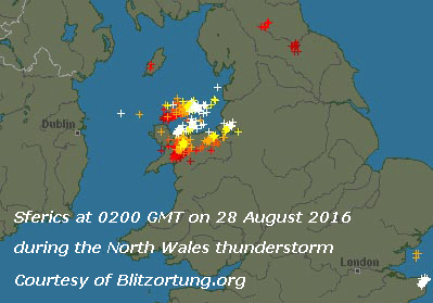
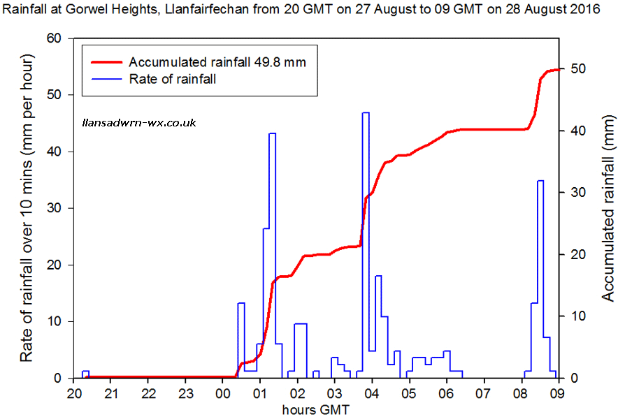
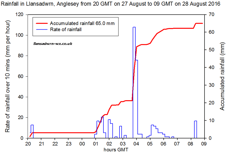
Much the same starting the 5th, but pressure 10120 mb was rising in a ridge of high-pressure from high 1025 mb near Cap Finisterre. It was a calm morning and cloud cover was moderately high and began thinning with sunny spells developing with clear sunshine later [Max 19.7C Min 10.5C Grass 6.7C Rain nil] (Gravesend 24.6C). A fine and sunny morning on the 6th with very good visibility and a temperature of 17.9C at 0900 GMT. Overnight the minimum was 13.2C and 10.0C on the grass and there had been a moderate dew. Pressure was steady on 1025 mb in a ridge with high 1029 mb over the Vendée, France. Low 988 mb was W of Ireland and there was an occluded front over NW Scotland. Cloudier and breezy in the afternoon with a maximum of 20.6C just after noon. Warmer in Llanfairfechan with Gorwel Heights reporting 24.9C and Gorddinog AWS 23.6C (Cavendish Suffolk 27.0C Hawarden 25.3C) [Max 20.6C Min 13.2C Rain 0.5 mm]. Mostly cloudy and breezy on the 7th and 16.0C at 0900 GMT after a minimum of 13.7C. Pressure was 1021 mb with low 983 mb between Scotland and Iceland with an associated cold front clearing southern England. The day mostly cloudy (orographic waves) with not a lot of sunshine, but kept dry [Max 19.0C Min 13.7C nil rain]. Another dry day on the 8th with pressure 1022 mb continuing to rise. Low 985 mb was over the S Norwegian Sea; with a WNW'ly breeze convective clouds persisted over SE Anglesey and Snowdonia [Max 18.9C Min 11.2C nil rain]. The 9th was a much duller day with dark cumulus clouds threatening showers in the morning, and by afternoon thickening to give some slight rain at times. Soil moisture determined today under grass was 53.7% dm [Max 16.2C Min 9.2C Grass 5.0C Rain trace]. The sky was overcast on the morning of the 10th with pressure steady on 1026 mb. Low 1006 S Greenland had an associated warm front extending over the Irish Sea. Clouds had thickened by 0900 GMT and there were some spots of rain at 0920 GMT. The afternoon kept dull with slight rain and drizzle at times with poor visibility [Max 15.8C Min 9.9C Grass 8.3C Rain trace]. With pressure steady on 1026 mb on the 10th the sky was overcast under a warm front over the Irish Sea and a clod mass covering most of northern Britain, except the far north. With the cloud thickening towards 0900 GMT it was not long before there was drizzle came along setting the scene for the day. There was persistent drizzle and light rain in the afternoon with poor visibility, into the evening rain petering out after 21 GMT. The day's maximum of 15.8C was at 1230 GMT; sunless [Max 15.8C Min 9.9C Grass 8.8C rain 3.4 mm]. After a dry night the morning of the 10th began overcast and dull with cloud thickening bring slight drizzle by 0920 GMT. Pressure here was 1026 mb and although there was a mid-Atlantic high 1037 mb low 1006 mb S Greenland had an associated slow-moving warm front over the Irish Sea. The day was sunless with drizzle and light rain persisting with poor visibility into the afternoon. [Max 15.8C Min 9.9C Rain 3.4 mm]. Much the same on the 11th, grey overcast sky, very poor visibility and spells of light to moderate rain in the morning. The afternoon and evening were dry, but sunless [Max 16.5C Min 12.3C Rain 3.4 mm]. Early on the morning of the 12th the sky was almost clear for a while then turned cloudier with 6 oktas cover at 0900 GMT. Pressure was keeping steady on 1023 mb with low 995 mb SE Iceland and low 999 mb Faeroe Islands. A cold front was lying across Malin Head and western Scotland. The afternoon had a strong breeze, but it was bright and with some sunny spells was welcome after the previously dull days. Some rain showers in the evening [Max 17.6C Min 12.6C Rain 1.1 mm]. After a mild and dry night the 13th began brightly with good, hazy visibility. Pressure 1022 mb was rising and there was a light W'ly breeze. There were a few sunny spells through the day that again kept dry [Max 17.8C Min 13.2C Rain nil]. A cloudy night and morning on the 14th and the cloud thickening further through the morning. Pressure was 1026 mb and the temperature 15.3C at 0900 GMT with very good, clear, visibility. Though cloudy and sunless it was another dry day [Max 18.4C Min 12.7C Rain nil]. The 15th began brightly with a light S'ly breeze, very good visibility and pressure on 1025 mb. A warm mostly sunny day on Anglesey and Western isles of Scotland with some patchy cirrus clouds mostly to the north [Max 22.7C Min 10.4C Grass 8.0C Rain nil] The first 15-days were dry with just 9.7 mm of rainfall. (10%) & [11%] of the months averages. Temperatures were near averages with the mean 15.3C (+0.2) & [-0.3] of averages The 16th continued the settled spell of fine weather. Pressure 1019 mb had declined a little with high 1025 mb over the North Sea. Low 982 mb was just S of the Denmark Strait brought several wet and windy days to Iceland and SE Greenland. Here fine and sunny with gentle S'ly breezes at first when the temperature reached 26.0C, highest of the month, and a sea breeze off Red Wharf Bay later in the afternoon. Solar radiation was 20.94 MJ m -2 , highest of the month [Max 26.0C Min 13.2C rain nil]. Much the same on the 17th as pressure slowly declined to 1013 mb. Frontal cloud lay to the W in the morning when there was a light NE'ly and this encroached by afternoon when the breeze veered SSW'ly, the temperature rising to 24.3C a third day >20C [Max 24.3C Min 13.3C Rain nil]. The 18th began very dull and the chance of a fourth day with 20C seemed remote. By afternoon the sky was clearing and there were sunny spells when the temperature rose to 23.3C in a light S'ly breeze [Max 23.3C Min 14.0C Rain 6.0 mm]. At midnight on the 19th pressure had fallen to 1006 mb with low 983 mb off SW Ireland tracking towards the Irish Sea bringing frontal cloud to Wales and SW England. There was mostly light rain from 0340 GMT that had accumulated 6.0 mm by 0900 GMT. Pressure had fallen to 1011 mb and it was a very dull morning with more light to moderate rain the S'ly breeze picking up by noon. After the barometer had fallen to 999 mb around 1445 GMT the afternoon was brighter with some sunshine after the cloud had cleared. Pressure continued to fall and was 998 mb at 1800 GMT and the SSW'ly wind freshened to a strong breeze before midnight when there was moderate to heavy rain [Max 19.6C Min 14.2C Rain 14.5 mm]. At midnight pressure was 997 mb here with the low 979 mb near Shannon, Ireland. On the morning of the 20th there was rain just before 09 GMT when the SSW'ly was force 4/5 and pressure fallen to 993.6 mb as the low passed over. There was further spells of moderate rain in the morning with the wind gusting to 35 mph. There was a lull in the rain when the sky was lighter, but not the wind that continued to blow strongly with moderate to heavy showers of rain starting again around 14 GMT then later slight rain showers and drizzle at times the wind moderating slowly [Max 16.5C Min 13.2C Rain 10.3 mm]. On the 21st pressure 1014 mb had risen as the low 994 mb transferred to the North Sea off Tynemouth. Early showers of rain and a mostly cloudy morning the SW'ly force 3 and sky brightening, moderate visibility and some glimpses of sunshine coming along. There was no further rain until late in the afternoon when cloud had encroached once again. After a dry beginning to the month there has been 37.0 mm in the last 3 days that have also been mostly dull [Max 17.9C Min 14.0C Rain 12.2 mm]. Continuing dull on the 22nd with overcast skies and a SW'ly breeze. Recent moderate showers gave way to more showery bursts through the morning, sometimes heavy. Pressure 1021 mb was steady on 1018 mb with low 993 mb was S of Iceland, W of Scotland and there was a triple point frontal system over the North Channel. The morning was overcast here with thick blanket of cloud, at 0900 GMT the light level was only 20 W m -2, the day was sunless the dullest of the month with total solar radiation of only 4.22 MJ m -2 [Max 18.4 Min 14.2C Grass 14.9C Soil at 5 cm 16.7C 30 cm 17.2C Rain 6.8 mm]. Showers overnight and bright early on the 23rd, improving moderate to good visibility with some glimpses of sunshine in the morning. Pressure had 1021 mb had risen in a weak ridge, but low 997 mb was still S of Iceland with an associated frontal system over the Irish Sea; pressure was high 1028 mb over S Greenland and 1031 S Europe. The afternoon was brighter with some sunshine and in a S'ly breeze the temperature rose to 23.2C the fourth highest of the month [Max 23.2C Min 13.5C Grass 10.5C Soil 5 cm 17.1C 30 cm 17.9C Rain 0.2 mm]. The 24th began mostly clear and calm between weak cold frontal systems lying in the W between the Celtic Sea and Scotland. At 0900 GMT pressure was 1022 mb with slow-moving low 997 mb still S of Iceland. A mostly sunny day Valley reporting 11.7h and solar radiation here 17.42 MJ m -2- third brightest of the month [Max 20.0C Min 13.6C Rain nil]. On the 25th a band of frontal cloud sliding NE lay across W Britain with E Ireland, N Scotland and the far SE of England clear. The low S of Iceland still slow-moving much was filling 1002 mb and pressure here was 1017 mb. Mostly cloudy and dull except in the evening when a glimpse of the setting sun was seen under the cloud sheet [Max 18.6C Min 13.3C Rain nil]. Cloudy overnight and at dawn on the 26th. Pressure was steady on 1017 mb with the S Iceland low filled to 1005 mb as a new mid-Atlantic low developed. The morning with a light SW'ly breeze and very good visibility brightening with sunny spells developing through the morning and into the afternoon, a third successive dry day [Max 19.1C Min 12.0C Rain nil]. The 27th began with some cloud, a little sunshine, a light S'ly breeze and moderate visibility. Pressure was on 1019 mb with low 1001 mb off SW Ireland tracking towards the Bristol Channel. Largely due to the thunderstorm on 27/28th contributing 65.0 mm the month ended with an above average rainfall of 133.0 mm (137%) & [153%] of averages, most since 2013 rank 15, and one of the 36 Augusts in the Llansadwrn record book having over 100 mm since 1929. Temperatures were above average, the mean 16.1C highest since 2004 (+1.0) & [+0.5] of averages ranking 8 since 1979. Sunshine was a little above average.
September 2016September 1 - began promisingly with a weak ridge of high pressure crossing overnight with some clear spells and a bright dawn with heavy dew on the grass and a minimum of 6.2C. Breezy with cloud encroaching moving in across the Irish Sea associated with a low 985 mb over the Denmark Strait. Another low 997 mb was over the North Sea while pressure was high 1026 mb N Biscay. The SW'ly breeze strengthened in the afternoon that remained cloudy and dull [Max 17.4C Min 10.2C Rain 4.3 mm]. Pressure was on 1016 mb on the 2nd that began brightly with glimpses of sunshine and at 0900 GMT a temperature of 16.0C. Mostly cloudy here, although Valley reported 7.5h of sunshine, there was a little rain early in the evening [Max 18.0C Min 14.2C Grass 13.6C Rain 0.5 mm]. Dull and overcast again on the 3rd with light rain and misty low cloud on the lower slopes of the Snowdonia Mountains. Pressure 1012 mb was falling as a large area of rain falling on central Ireland, the Irish Sea and Wales moved eastward during the day giving wet weather in Cumbria and the Pennines as well. Lows to the SW, including remnants of the now merged ex-hurricane Gaston 1004 mb over the Atlantic W of Cap Finisterre tracking north. Rain was moderate to heavy at times during the morning Ahead of the Gaston-complex, pressure 1012 mb here, was falling reaching 1004 mb in the afternoon as a frontal-wave pushed over the Bristol Channel. The afternoon was drier, but the day remained overcast and sunless [Max 17.2C Min 12.8C Rain 15.4 mm]. No better on the 4th although pressure 1011 mb was rising quickly in a minor ridge over Britain. Lows 986 mb Denmark Strait and 1002 mb N Sea with pressure keeping high 1021 mb over Spain. Mostly cloudy with slight rain showers at times, brighter later in the afternoon with a glimpse of sunshine daytime maximum was 16.5C at 16 GMT [Max 17.8C Min 12.8C Rain 3.6 mm]. Another dull and damp morning on the 5th, cloud was low on the mountains with misty visibility and slight rain and or drizzle. Pressure on 1014 mb was rising as with a frontal-wave triple point over the Irish Sea we were in warm sector air the temperature rising to 18.1C at 0900 GMT, pity about the 96% RH; Gorwel Heights reached 19.1C. Low 977 mb was S of Iceland while high 1025 mb was centred near Bilbao, Spain. The rain slowly faded away and by noon the sky began to clear and yes, the sun came out later and the temperature rose to a warm 22.6C [Rain 0.1 mm]. In warm sector air overnight the minimum air temperature on the 6th was 16.9C, the highest on record here. Briefly bright after dawn before low cloud and mist moved in bringing slight rain and drizzle and very poor visibility through the morning then bright and warm by the afternoon; at Gorwel Heights the temperature reached 24.5C [Max 21.1C Min 16.9C Grass 15.3C Rain trace]. Warm again overnight and yesterday's record minimum was beaten on the 7th by the 17.2C recorded this morning. Pressure was on 1017 mb with high 1028 mb near St. Petersburg, lows 995 mb were SW of Ireland and Gulf of Bothnia. Very fine, warm and sunny; the temperature at 0900 GMT was 18.8C and this rose to 23.4C by mid-afternoon [Max 23.4C Min 17.2C Grass 16.2C Rain 3.9 mm]. The 8th began with showery rain from 0430 GMT ceasing just before 0900 GMT. At midnight on the 8th there was a low 990 mb W of Shannon, Ireland and we were still in warm sector air at 20.5C. Then a weak cold front moved over the Irish Sea and the temperature began to fall. Pressure was on 1006 mb with complex low-pressure lying to the NW (986 mb). The afternoon turned fine with some sunny spells. There was some showery rain during the evening. [Max 17.8C Min 13.5C Rain 2.9 mm]. On the 9th there was showery rain from 0530 to 0715 GMT. Low 977 mb was W of Shannon and we were in a strong W'ly air flow. At 0900 GMT the sky was clearing, with pressure on 1008 mb, with some glimpses of sunshine. These did not last and it was cloudy again with spots of rain at 10 GMT. Wet and windy and in the force 6/7 SSW'ly wind, gusting to 53 mph in the area: leaves and twigs were being blown off the beech trees leaving the ground littered with twigs some with with still-green leaves attached; a lot of Bardsey apples were blown off too. A sunless day [Max 18.4 Min 13.1C rain 9.2 mm]. The 10th started brightly with a clearing sky and glimpses of sunshine, but was soon cloudy again. Pressure at 0900 GMT was rising with low 974 mb Denmark Strait and 965 mb over the Norwegian Sea. Frontal cloud had transferred to S England and NW France. Later in the afternoon the sky cleared with sunshine and a fine evening. Picked a good bag of blackberries along Blackhorse Lane and Peacock Hill [Max 18.4 Min 10.1C Grass 7.3C Rain nil]. A fine sunny morning on the 11th with a light to moderate S'ly breeze and moderate hazy visibility. Pressure was 1014 mb with low 975 mb W of Ireland with fronts cloud. Isobars were tightening and it became very windy in the afternoon force 6.7 at times with strong gusts that blew over some large potted plants. With a few strongly reflective clouds in the sky solar radiation 13.65 MJ m -2 was highest of the month. [Max 18.8C Min 10.8C Rain nil]. The wind had not eased by the 12th and was S'ly force 6 in the morning. The temperature at 0900 GMT was 18.8C, the maximum of the past 24-h and, despite remaining mostly cloudy, rose to 22.1C here and 23.9C at Gorwel Heights. High evaporation rates today; M. Piche's evaporimeter measured 4.5 mm, largest of the month [Max 22.lC Min 14.8C Rain 0.1 mm]. The 13th began overcast and during the hour before 09 GMT became very murky the cloud thick enough to produce some drizzle and slight rain. . There were thunderstorms developing in Brittany and the Gironde in France. Later storms developed in S Britain and in Manchester between 6 - 10 pm where there was vivid lightning strikes and torrential rain. The tramway system was closed down as well as the airport. Much damage was done the telephone/ internet infrastructure around Manchester, Birmingham and further S including Southampton. SKY satellite signals were also interrupted for a while (Gravesend 34.4C; Cambourne 40.0 mm) [Max 18.2C Min 16.0C Rain nil; Culdrose 47.8 mm]. There was sea fog around the coastline on the morning of the 14th and visibility at 09 GMT was poor. Soon becoming sunny with lee-wave clouds developing to the S of the weather station. It was a warm and sunny afternoon the temperature highest of the month [Max 23.7C Min 15.2C Rain nil]. After a mild night a rather cloudy, but warm and humid morning on the 15th with the temperature on 16.9C at 0900 GMT. Soon brightening with sunny spells developing in the afternoon [Max 21.5 Min 16.3C Grass 16.5C Rain nil]. The first 15-days temperature was well above average with the mean 16.8C (+2.9) & [+3.0]. Rainfall was 43.3 mm [(45%)] of the average. The 16th began with rather misty poor visibility at 0530 GMT, but began to clear so that soon there were glimpses of sunshine. A fine and dry day ensued as pressure 1016 mb rose with high 1029 W of Cap Finisterre and frontal cloud well to the east [Max 17.5C Min 10.8C Rain nil]. Similar on the 17th with pressure steady on 1024 mb, fine, bright and dry. Wet in SE England Manston [47.2 mm] [Max 18.2C Min 10.4C Grass 6.7C Rain nil]. A clear dawn on the 18th after a cooler night (grass min 5.6C) then turning cloudier by 0900 GMT. Pressure was 1021 mb with mid-Atlantic high 1033 mb, but there was a weak trough encroaching from the west, there was little in the way of any sunshine and light rain and or drizzle came along from 1600 GMT continuing until after midnight [Max 17.9C Min 9.6C Grass 5.6C Rain 4.0 mm]. The last of the rain was about 0230 GMT on the 19th and after dawn there some patches of blue sky appeared; there was a light N'ly breeze and visibility was very good and clear. Pressure 1025 mb was rising, it was unsettled in the Med with low 1006 mb over the Adriatic and deep low 988 mb was S of the Denmark Strait. The day kept mostly cloudy with a few spots of rain in the afternoon, but it was sunny at times [Max 16.6C Min 12.1C Rain trace]. The morning of the 20th was very fine and bright with good or very good visibility. Although cloud could be seen in the west the afternoon was sunny at times and the day kept dry [Max 16.6C Min 9.7C Rain nil]. Pressure 1015 mb was falling on the 21st with low 990 mb S of Iceland and W of Scotland that had an associated cold front W of Ireland. The morning began fine and bright with moderate to good hazy visibility. The afternoon was dull with spots of rain at times before showers developed later in the evening. [Max 17.5C Min 9.4C Rain 2.3 mm]. A cooler morning on the 22nd after a light shower of rain about 05 GMT; the 0900 GMT temperature was 10.5C. The afternoon was mostly sunny [Max 15.9C Min 8.1C Rain 2.0 mm]. Another mostly dry and fine day on the 23rd, beginning with 3 oktas of cloud cover mostly cirrus with some cumuli. There were just a few spots of rain in the afternoon, an unmeasurable amount [Max 17.5C Min 9.0C Rain trace]. During the evening (from 1830 GMT) the temperature 13.7C began to rise and at midnight on the 24th was 14.6C continuing to rise to 17.1C at 0630 GMT (20.7C at Gorwel Heights with gusts up to 39 mph) and 17.2C at 0900 GMT. A breezy morning the S'ly force 5/6 with strong gusts continuing; crepuscular rays were seen earlier in the day with moderate hazy visibility. There was rain around 1630 GMT [Max 17.2C Min 13.3C Rain 9.0 mm]. The 25th began fine with a sunny morning. Pressure 1009 mb was rising and we were in a clear slot covering the Irish Sea. Complex low 987 mb was lying between Scotland and Iceland resulting in a showery airstream over Britain and Ireland. Light showers developed in the afternoon then a heavy one with ice pellets fell at 1613 GMT [Max 15.8C Min 10.6C Pptn 7.4 mm]. The 26th began with a complex Atlantic pressure chart showing a low 1005 mb off SW Ireland and low 997 mb S of Iceland and NW of Cape Wrath while pressure was high 1025 mb over the Franco Belgium border. Here pressure was steady on 1017 mb and the sky overcast with poor visibility after recent heavy rain. It was still raining at 0900 GMT, but slowly easing leaving a very dull morning By afternoon it had improved and there were some sunny spells [Max 16.4 Min 9.6C Rain 4.4 mm; Capel Curig 24.4 mm]. The 27th began overcast again with the cloudbase low on the mountain slopes. Intermittent slight rain, dull and damp. Complex low 982 mb was S of Iceland and pressure here 1016 mb was rising and the afternoon was dry with a little sunshine [Max 18.5C Min 11.3C Rain 0.6 mm]. Keeping with the generally overcast theme the 28th was indeed overcast, dull and sunless. [Max 17.5C Min 13.5C 4.8 mm; Capel Curig 32.4 mm]. A brighter morning on the 29th as low 976 mb moved eastwards N of Scotland reaching the S North Sea at 09 GMT. A showery W'ly airflow had been introduced and the morning was breezy with the odd slight shower of rain; the afternoon was fine with sunshine [Max 16.0C Min 11.2C Rain 0.1 mm]. After a cool night with a grass minimum of 5.1C, lowest of the month the 30th was fine and mostly sunny with very good visibility [Max 14.3C Min 8.8C Grass 5.1C Rain 6.4 mm].
The drier than average month ended with a rainfall total of 84.3 mm (87%) & [88%] of averages rank 32 least since 1928, but most since 2012. Warmer than average with the mean of 15.3C joining with 2014 as the second warmest September in station records. Notable was the high minimum 17.2C on the 7th which was a record for September. Sunshine recorded at RAF Valley was [101%] of the 30-y average.
October 2016October 1 - was a wet day beginning with moderate rain at 0900 GMT. There was a low 1002 mb near the Pembrokeshire islands with pressure here 1005 mb. An occluded front was slow-moving over Wales and although the rain eased it did not brighten up until late afternoon when a few glimpses of sunshine were seen [Rain 7.1 mm Max 11.3C Min 8.3C]. With an Atlantic-ridge moving over from the W overnight the morning of the 2nd was almost cloudless with some small cumuli seen to the S over the mountains. Pressure 1018 mb was rising the low 1005 mb over the southern N Sea filling and reaching the Netherlands by 09 GMT. There was mist across the fields along with heavy dew at 0530 GMT the temperature on the grass having gone down to 2.9C the lowest since the 16th May. In sunshine the temperature rose to 16.8C in the afternoon. The Michaelmas daisy, flowering about a month later this year, attracted several butterflies including 4 red admirals and hoverflies. Honey bees, that have had a poor season, were conspicuous by their absence as were many bumblebees; there were still, however, quite a few wasps around [Max 16.8C Min 7.3C Grass 2.9C Rain nil]. A fine and bright morning on the 3rd after another cool night the temperature a\t 0900 GMT was 12.7C. Pressure 1027 mb was still rising as the blocking high over S Norway reached 1033 mb. Low 956 mb SE Greenland and low 990 mb off Shannon, Ireland, had associated cloud over Ireland and W Scotland. Solar radiation 12.67 MJ m -2 today was highest of the month. A warm afternoon with the temperature reaching 18.1C at 1410 GMT (Porthmadog 18.6C). Another dry day over most of the UK, most was the 0.8 mm in Castlederg [Max 18.6C Min 8.0C Grass 4.0C]. Pressure 1029 mb was rising on the 4th with high 1049 mb Scandinavia. There was a frontal-wave 1014 mb off Brest with associated frontal cloud W of Ireland. Bright, with cloud amounts increasing although cloudier today there were sunny spells and it was another dry day [Max 16.5C Min 9.8C]. A largely sunny day on the 5th after a mild night minimum 11.8C the temperature at 0900 GMT was 13.3C and rose to a maximum of 17.9C at noon. A small red squirrel (kitten) was seen around the garden having water and taking crab apples. Maxima Bridgenorth 19.3C Valley 19.1C [Max 17.9C Min 11.8 Grass 7.6C Rain nil]. A cooler start to the 6th after an overnight minimum of 8.3C and 4.8C on the grass. Pressure was steady on 1029 mb and the day was cloudier and thick enough for a little drizzle at mid-day. Sunnier at Valley where 9.6 hours of bright sunshine was recorded [Max 14.3C Min 8.3C Grass 4.8C Rain tr]. Pressure on the 7th was steady on 1024 mb with the high 1042 over Norway. It was cloudy as a detached occluded front was over North Wales and stretching over the Thames Estuary. There were fronts also W of Ireland associated with low 987 mb Greenland but not making progress eastward due to the blocking Scandinavian high. The weather in the Med was unsettled with a low 1006 mb over the Silurian Sea. A dull and sunless day [Max 14.2 Min 8.9C rain nil]. Not a lot of change on the 8th, a mostly cloudy day, but dry with some glimpses of sunshine. Pressure 1029 was still rising slowly with the settled spell continuing. There are good supplies of autumn blackberries along the hedgerows, picked a bag to make apple and blackberry crumble [Max 15.0C Min 10.8C Rain nil]. A clearing sky after dawn on the 9th with very good visibility. The grass minimum was down to 4.6C, but the grass was hardly damp. There was a light E'ly breeze and pressure steady on 1031 mb. The Scandinavia high 1043 mb was still holding with a ridge to the UK. Fine with sunny spells coming along in broken cloud in the lee of the mountains and a mostly sunny afternoon Maximum Helens Bay 17.4C Porthmadog 16.8C [Max 14.5C Min 8.3C Rain 0.1 mm]. After a shower of rain about 07 GMT on the 10th the sky was starting to clear at 0900 GMT It was calm, the anemometer was still with not a movement shown by the leaves on the tallest trees. Cloud was moving from the NNE direction. Showery rain during the morning, with some weak sunshine developing, then sunnier in the afternoon Maximum Helens Bay 15.9C Milford Haven 15.4C; Min Braemar -4.1C [Max 12.5C Min 6.2C Grass 2.7C Rain 1.2 mm]. A fine and bright morning on the 11th with a heavy dew on the grass the minimum reading 2.7C. A few cumuli and cirrus clouds with a NNE'ly breeze, good hazy visibility. A mostly sunny day [Max 13.4C Min 6.1C Rain 0.4 mm]. A mostly cloudy start on the 12th with pressure 1025 mb keeping steady dominated by the Scandinavia high now S Norway 1039 mb. Unfortunately there was frontal cloud over Wales, but the cloud broke up later and there were some spells of sunshine. Another dry day [Max 14.0C Min 9.1C]. Some clear spells overnight, so cooler on the grass with the minimum 3.3C with moderate dew on the morning of the 13th. Pressure 1017 mb was falling as the S Norwegian high 1038 mb began a slow decline. There was an E'ly breeze with moderate to good hazy visibility. Very fine and bright at first then cloudier with sunny spells Maximum Porthmadog 15.6C [Max 12.9C Min 7.3C Grass 3.3C Rain nil]. A misty morning on the 14th especially in low lying areas. Pressure was on 1007 mb. There were storms in the South of France (1001 mb) and there was a low 997 mb off SW Ireland. A fine day, mostly cloudy, but bright day [Max 14.0C Min 5.7C Rain 0.7 mm]. Early showery rain on the 15th with 0.7 mm recorded at 0900 GMT. A cold front associated with the low 993 mb off SW Ireland was over Cardigan Bay. There were cumulus clouds over the mountains and visibility that was poor had improved to moderate. The morning brightened, with mist clearing, but the afternoon was mainly cloudy with some spots of rain around 1300 GMT. After the temperature had reached a minimum of 8.1C close to midnight it began to rise Maximum Gravesend 18.4C Rhyl 15.8C; (Aboyne 38.4 mm) [Max 14.8C Min 8.5C Rain 0.4 mm]. The first 15-days had been dry with only 9.9 mm rainfall [8%] of average. The mean temperature 11.5C was on the decadal average (0.0), but above [+0.6] the 30-y average. Pressure on the 16th was on 1006 mb with low 992 mb SW Ireland tracking N with frontal cloud over the Irish Sea. Hurricane Nicole 968 mb was showing up on the Atlantic charts S of Greenland. The sky at 0900 GMT was clearing a little after a slight shower and there was a light SSE'ly breeze. Becoming breezy later in the morning an into the afternoon. Heavy showers came along in the afternoon and thunder was heard while picking 2.2 lb of blackberries along the hedgerows in Blackhorse lane (1310 GMT, 51 mm/h). The hedges have not yet been trimmed and there are plenty of late blackberries to be had. More heavy showers in the evening (51 mm/h at 2300 GMT) with the roof gutters overflowing Maxima Kew Gardens 18.6C Cardiff 17.3C; Bournemouth (30.4 mm) Sennybridge (25.6 mm) [Max 14.8C Min 8.1C Rain 14.4 mm]. Rainfall in the 24-h to 0900 GMT on the 17th was 14.4 mm and was the largest daily fall in what was quite a dry month. Pressure 1012 mb was rising quickly with the low 998 mb now positioned off Cape Wrath. There had been a blustery shower (37 mm/h) at 0650 GMT, but the sky was now clearing rapidly and it was fine an sunny for a while before turning cloudier once again later [Max 14.0C Min 9.3C Rain 3.8 mm]. Waiting for the first snow of the season some had fallen on Cairngorm Mountain on the 18th, but had soon melted, none had been in Snowdonia. At midnight a cold front over the Irish Sea had produced a small fall in temperature and 'sharp' showers the precipitation had been of rain. At 0900 GMT pressure 1019 mb was rising with an Atlantic-high 1030 mb W of Brest and hurricane Nicole 979 mb was S of Greenland. The cold front was lying from the Western Isles across central England and there were following showers. The sky had cleared, it was fine, sunny and cool. By 1030 GMT clouds had returned and there were some spots of rain [Max 11.6C Min 6.6C Grass 4.7C Rain tr]. The 19th was fine with some sunny spells [Max 13.7C Min 7.7C Rain 0.9 mm]. Pressure 1025 mb was rising on the 20th in a col between low-pressure 1014 mb over the Atlantic and 1011 mb near Denmark. A fine morning, cloudier around noon with moderate showers, little in the way of sunshine in the afternoon [Max 12.4C Min 8.2C Rain 2.0 mm]. Fine and bright on the 21st at first, but then keeping mostly cloudy it was a dry day [Max 13.5C Min 6.1C Grass 2.8C Rain nil]. Some clear sky overnight and a heavy dew on the grass on the 22nd. Pressure steady on 1019 mb it was fine and mostly sunny (Valley 5.6h) with very good slightly hazy visibility {Max 12.4C Min 5.9C Grass 2.5C Rain nil]. Similar on the 23rd, a bright morning with dew on the grass after the lowest minima of the month air 5.5C and grass 1.8C. Cumuli were developing over the mountaintops, fair weather clouds over Anglesey and a mostly sunny afternoon (Valley 6.3h), another dry day [Max 10.6C Min 5.5C Grass 1.8C Rain nil]. The 24th was a mostly cloudy, sunless and cool day, the maximum of 10.6C was lowest of the month, it was again dry. Leaves have been falling off the trees steadily and the crowns are looking rather thin, some leaves have been showing moderate autumn tints. Wet in the south Plymouth (39.0 mm) sunniest in the north Kinloss 8.8h [Max 10.6C Min 6.7C Rain nil]. The 25th began overcast and dull, but brightened up and there were some glimpses of sunshine. The evening had a slight shower of rain [Max 13.6C Min 7.8C Rain 3.4 mm]. After midnight on the 26th there were showers of rain (29 mm/h at 0346 GMT) that produced 3.3 mm. Mild at 0900 GMT 12.3C and misty with moderate visibility. Pressure was on 1025 mb and there were complex frontal systems over Britain associated with low 974 mb Iceland. There was a high 1028 mb over Brittany. Bright at times, but thicker cloud in the afternoon produced some drizzle for a while [Max 13.6C Min 9.6C Rain tr]. Keeping mild the 27th was overcast and dull with a temperature of 12.6C at 0900 GMT here and 7C on the summit of Snowdon with no chance of any snow. Breezy. Showers from 1800 GMT continuing through the night [Max 14.8C Min 11.5C Rain 3.0 mm]. The 28th began with moderate fog at 0900 GMT. A mild 12.8C with 97% RH and low cloud after an overnight minimum of 12.3C that was highest of the month. It remained dull and damp all day and with solar radiation of only 2.58 MJ m -2 made it the dullest day of the month [Max 14.0C Min 12.3C Rain 0.4 mm]. Similar on the 29th, poor visibility dull and damp with intermittent slight drizzle in a warm front stretching from Scotland to East Anglia. Pressure was 1035 mb with high 1036 mb over the Channel and Dover Strait. Drier and brighter in the afternoon, but no sunshine [Max 12.8C Min 11.6C Rain tr]. On the 30th it was again overcast. It was fine, but there was a thick smoke (pollution) and dust haze here and over N Europe trapped in the high pressure 1030 mb here 1033 mb Europe. Unusual 'tropical' type storm in the Mediterranean east of Sicily [Max 12.1C Min 8.9C Rain tr]. The last day of the month the 31st produced a remarkably fine day. Clear skies overnight with bright stars and a mostly sunny through cirrus clouds and some contrails (Aberdaron 6.7h). There was low lying inversion haze in the Menai Strait early, but visibility above this was very good. Maximum Trawsgoed 22.2C [Max 15.5C Min 8.2C Grass 4.7C Rain nil]. The driest October here since 1978. The 37.9 mm rainfall was just [(29%)] of average and the 5th lowest in Llansadwrn records since 1928. Temperatures were close to the averages with the monthly mean 11.1C (-0.4) & [+0.2] lowest since 2012.
November 2016November 1 - began overcast dull and misty, there was a light NNE'ly breeze. Pressure 1026 mb was rising with Atlantic-high 1040 mb lying to the W and S of Iceland with cold front that was over the North Channel near midnight had moved to be over Anglesey and moving further S introduced clearer fresher air [Max 12.0C Min 10.2C rain 0.7 mm]. The 2nd began fine and sunny with very good visibility, air behind the front was cooler; conditions around the mountain summits were wintry with icy flurries, but no ice precipitation was seen on the ground at 0900 GMT. Sunny at times; a line of dark clouds were slow-moving and positioned overhead in the afternoon and produced a few spots of rain [Max 12.1C Min 5.8C Grass 3.2C Rain trace]. With some clear sky overnight the air minimum on the morning of the 3rd was 5.7C, but there was no ground frost with a minimum of 1.8C. It was finer, but dull the sky having turned cloudier. There was rain off the Scilly Isles and Cornwall and to the NW of Anglesey, over Ireland, the Isle of Man and Scotland, but the morning kept dry the rain eventually reaching here at 1345 GMT giving a few hours of light rain and intermittently heavier rain in the evening and a heavy burst at midnight [Max 10.6C Min 5.1C Grass 1.2C Rain 4.4 mm]. Dull and overcast at dawn on the 4th after a light shower of rain. Signs that the sky was going to clear at 0900 GMT with a light SW'ly breeze. Precipitation was in sight crossing the mountain summits was likely to be wintry. Pressure 1010 mb was falling slowly with low 1003 mb N North Sea with Atlantic-high 1031 mb. Here the morning brightened becoming mostly sunny by 1130 GMT, but there were cumuli in the vicinity. Showers on the mountains in the afternoon, looked wintry. The wind turned N'ly by evening when there were showers. [Max 11.0 Min 5.2 Rain 4.4 mm]. On the 5th, a bright sunny at times morning. Good or very good visibility, a sliver of snow was seen capping the summit of Carnedd Llewelyn, the first of the season. There was some too on the ground on Cairngorm Mountain in Scotland. The jetstream was divided with strong showery N'ly airflow from Norway and Baltic regions. An elongated high-pressure area 1032 mb lay from Iceland to the Azores with a low 998 mb over the North Sea. A fresh N'ly breeze the temperature at 0900 GMT 6.6C dewpoint 3.0C. Cloudy at times with sunny spells. Windy on the Llansadwrn ridge in the afternoon when there were a few spots of rain [Max 8.1C Min 6.2C Rain tr]. There were snow showers on the morning of the 6th across the Snowdonia mountaintops. The day was mostly cloudy and there was a persistent cold N'ly breeze. Highest max today was at Chivenor 10.8C [Max 7.7C Min 5.9C Rain 0.4 mm]. On the 7th a moderate to strong NNE'ly breeze, good visibility. Recent light shower of rain here, but there was snow on the mountains lying at 2500 ft on the Carneddau and Snowdon. The intermediate jetstream was divided into 4 main streams N - S with the N'ly flow continuing; there was a low 1001 mb on a frontal system near Dunkirk and Atlantic-high 1028 mb W of Iberia. The day was sunny at times [Max 9.0C Min 5.3C Rain tr]. An overcast morning on the 8th, it was less windy with a light SW'ly, the temperature 4.3C dewpoint 2.7C. The first ground frost of the season -1.8C read on the thermometer, but there was no frost seen on the grass at 0900 GMT. A fine, but dull morning with low cloud descending on mountains in the west. Slight rain in the afternoon becoming moderate in the evening with rising temperature [Max 8.4C Min 2.9C Grass -1.8C Rain 13.3 mm]. The temperature at 0139 GMT had risen to 8.4C the maximum of the past 24-h. On the morning of the 9th it was 6.4C and calm with moderate misty visibility, recent icy precipitation had ceased, 13.3 mm of rain was measured and the sky was clearing quickly. There were cumulus clouds developing in the vicinity with crepuscular rays seen looking towards the mountains. Then cloudier with a heavy shower with ice precipitation at 0955 GMT. Frequent light showers, again some icy, later in the day and during the evening and after midnight [Max 8.8C Min 4.3C Pptn 5.8 mm]. [Max 9.5C Min 5.3C Pptn 1.0 mm]. A bright morning on the 10th, the cumulus clouds in the vicinity were diminishing after overnight showers of icy precipitation. The temperature at 0245 GMT had been 7.7C, but at 0900 GMT was 6.6C (dewpoint 6.0C) with minima yesterday evening air 5.3C grass 0.5C. Slow-moving low 1003 mb near Dunkirk, frontal-wave low 997 mb near Rockall with occluded frontal cloud lying over central England; the jetstream looked more normal today with a NW - SE flow over Britain. More crepuscular rays, a maximum of 9.5C just before noon then a fine afternoon. Light to moderate showers of rain during the evening. Highest max 13.2C at Culdrose [Max 9.5C Min 5.3C Pptn 1.0 mm]. Another fine morning on the 11th after overnight ground frost of -1.2C, the air minimum 2.7C. Pressure 1021 mb was rising in a ridge from S Norway/ Baltic/ North Sea high 1027 mb. Very good visibility, blue sky with some broken cloud with several expanded contrails and a few small cumuli over the tops of the Llyn Mountains. Hazy sunshine in the afternoon. Several red squirrels at the feeder both adults and independent kittens through the day High max 13.3C at Plymouth; low min -5.4 at Braemar [Max 11.5C Min 2.7C Grass -1.2C Rain 1.2 mm]. Frontal cloud associated with low 971 mb Denmark Strait had encroached overnight on the 12th and it was overcast and calm at 0900 GMT; the grass minimum was on 0.0C so no frost recorded. The temperature was 11.0C 96% RH, but had been 11.3C near midnight. Moderate misty visibility; the cloud was thin and soon began to disperse and it was sunny by 1030 GMT and in the afternoon before warm moist air and cloud encroached with a shower in the evening [Max 12.6C Min 3.4C Rain 0.5 mm]. A fine bright morning for a while on the 13th after a slight overnight silver ground frost -0.2C. Visibility was moderate to good with some mist in low lying areas. Pressure was on 1029 mb with high 1033 mb in Sea Area FitzRoy off Cap Finisterre with ridge to the Celtic Sea. A warm front was approaching over the Irish Sea and the sky soon turned overcast and dull, with little or no wind, and a fine drizzle developed. Sunless [Max 11.9C Min 4.8C Rain 1.1 mm]. Little change on the 14th, pressure had declined a little 1027 mb and we had another dull and sunless day with slight drizzle. Today's maxima were at Aboyne 17.1C and Hawarden 16.2C [Max 14.2C Min 7.6C Rain 3.2 mm]. The 15th began overcast with fine drizzle and mist giving very poor visibility. The temperature at 0900 GMT was 12.8C and 98% relative humidity. Pressure was on 1026 mb and there was little change in the synoptic pattern with high 1037 mb over FitzRoy. The drizzle did ease and by afternoon the cloud was thinner, but the sun did not break through here. Maximum 17.2C at Herstmonceux [Max 13.0C Min 11.7C Rain 0.3 mm]. The first 15-days were cool compared with the last decade, but based on the 30-y climatological average warmer. The mean was 8.2C (-0.6) & [+0.5] of averages. It has been dry so far with rainfall was 36.5 mm [29%] of the 30-y average. On the 16th pressure 1012 mb had fallen, the high had moved to mid-Atlantic, and brought a change in the weather pattern as a cold front associated with low 968 mb Iceland passed over. At 0900 GMT there was a shower with a blustery SW'ly wind. Bright spells and showers followed on a W'ly breeze especially at 17 GMT and 18 GMT. The sky cleared for a while in the evening when the bright moon was visible, but now past being full. Maximum Kew Gardens 14.5C and wet at Cluanie Inn (41.4 mm) [Max 10.9C Min 8.9C Rain 2.2 mm]. There were some showers of rain after midnight when the temperature was around 7.5C on the 17th and in the morning the sky was overcast and dull and there was a blustery moderate to strong SSW'ly. Showers continued with a moderately heavy one mid-morning and a dry, but dull afternoon. Temperatures decreasing through the day from 7.8C near 09 GMT to 5.0C at 1700 GMT [Max 7.8C Min 5.9C Pptn 4.6 mm]. Showers developed around midnight on the 18th including snow pellets, enough to cover the ground, with the temperature fallen to 3.9C. In the morning there were still some snow pellets on the ground the minimum having fallen to 2.5C and on the grass -1.5C. There was a light covering of snow lying on the mountains above 1500 ft. The sky was brighter and visibility very good. There was a slight shower of rain and snow pellets mid-afternoon and evening [Max 7.5C Min 2.5C Grass -1.5C Pptn 1.1 mm]. A fine frosty morning on the 19th with some snow pellets lying on the ground after an air minimum of 2.0C and -3.0C on the grass. Five oktas cumuli that were developing and there was a slight shower of snow pellets at 0940 GMT. Named storm Angus was 996 mb over the western entrance to the English Channel. Pressure here was steady on 1000 mb, but started falling during the morning; the WSW'ly wind was light. The wind picked up a little around noon for a while; some bright spells during the day the temperature rising to 8.6C just after noon. [Max 8.6C Min 2.4C Grass -3.0C Pptn tr]. Just before midnight on the 20th the wind backed NNE'ly with pressure on 989.7 mb. The temperature had fallen to 2.0C in the evening, but then began to rise to 4.6C at 0900 GMT. The wind was light NNE'ly, but in the Dover Strait things were more lively. Angus was 970 mb and there were cold fronts over N France. A new Atlantic-low 986 mb SW of Ireland was of greater interest for the north-west later. Pressure here was lowest 987 mb at 0437 GMT and on 990 mb was rising. A fine and very nice afternoon, little or no wind [Max 7.8C Min 2.0C Grass -1.2C Pptn 0.7 mm]. With clear sky overnight the air temperature dropped to 1.9C and to 2.1C on the grass on the morning of the 25th. With hardly a cloud in the sky at 0900 GMT visibility was very good with a little smoke haze. Pressure 1027 mb continued to rise and was 1030 mb over the Irish Sea centred near the Isle of Man. Low 997 mb was just off the Iberian coastline with unsettled weather in Portugal and Spain. Max Plymouth 12.7C Min Tyndrum -9.5C [Max 7.4C Min 1.9C Rain Cu nil; black TB trace 0.2 recorded soon after 09z]. Clear sky overnight resulted in a grass minimum of -4.2C on the morning of the 26th with an extensive white frost in the garden and fields with bare soil surface frozen. There was a gentle NNE'ly and pronounced haze could be seen against the mountains with the tops above 1500 ft in the clear. Temperatures on the summit of Snowdon were between -4 and -7C and here 2.9C (dewpoint 1.9C) after a minimum of 0.6C, while at Gorddinog the AWS had recorded an air frost -0.2C and at Gorwel Heights the minimum was 1.8C. A fine sunny day. Max Leuchars 12.9C Porthmadog 11.4C; Aberporth 7.7h sunshine [Max 9.3C Min 0.6C Grass -4.2C]. The 27th was fine, bright and dry with a cool E'ly breeze. Pressure 1027 mb was rising under the influence of high 1031 mb over the Norwegian Sea. Complex weak frontal systems hung over Britain from the NW to SE Max Porthmadog 10.7C Min Braemar -3.6C [Max 9.0C Min 3.1C Rain nil]. Another fine day on the 28th with some hazy sunshine from time to time and a range of clouds types [Max 8.4C Min 3.4C Rain nil]. Clear and cold overnight and on the morning of the 29th widespread air and ground frost in large parts of Britain. Lowest air temperature here was 0.6C and on the grass that was white with frost it was down to -5.4C, lowest of the month. Both Valley and Mona air fields had air frost -3.1C and -5.0C respectively as well as Rhyl -2.8C. At 0900 GMT no clouds and no wind with a temperature of 1.4C (dewpoint -1.8C). Sunny afternoon. Max Tiree 10.3C Porthmadog 9.0C Min South Newington -7.5C [Max 8.4C Min 0.6C Grass -5.4 Rain nil]. In contrast the last day the 30th was cloudy and dull with shallow fog and mist at dawn across the fields at dawn, and although this disappeared by 0900 GMT the day kept cloudy. Visibility was very good and there was broken snow on the N-facing slopes and tops of the Carneddau. There was a little clearance in the west at sunset when there was briefly a red sky. Max Killowen 11.9C Min Sennybridge -9.7C [Max 7.3C Min 1.4C Grass -3.8C Pptn tr]. Although the month ended with over 110.5 mm of rain, largely due to the downpour on the 21st, it was relatively dry having (86%) & [88%] of the averages. Autumn rainfall with 232.7 mm was the lowest since 1955 and 4th lowest in Llansadwrn records since 1928. November was colder than usual with the mean temperature 6.9C, (-1.9) and [-0.8] of averages, was the lowest since 2010 and 6th lowest since 1979 Autumn mean temperature was 11.1C, lowest since 2012, but ranking 14 highest since 1979.
December 2016December 1 - ground frost overnight and early mist with poor visibility had, by 0900 GMT, begun to clear with weak sunshine breaking through. A damp morning with heavy dew left on grass. Bright at first with a little sunshine and blue sky then turning cloudier by afternoon. A dry day [Max 8.6C Min 3.5C Grass -1.7C Pptn tr dew]. Pressure was 1028 mb on the 2nd in the high centred on Dublin 1029 mb. Overcast with moderately high cloud above the tops of the Snowdonia Mountains with areas of broken snow mainly on north-facing slopes. A dull day and damp day sort of day with little or no wind [Max 8.1C Min 6.4C Grass 1.5C Pptn tr dew]. On the 3rd the high had moved to be 1028 mb over the Tyne and drifting out over the North Sea. Remnant frontal cloud was hanging around over central England, but here the sky was clearing with 5 oktas. Fine, with nice backlit cumuli at 0900 GMT with the temperature 4.0C rising to 7.2C just before 13 GMT made it the lowest maximum of the month [Max 7.2C Min 3.5C Grass -1.0C Pptn nil]. Chilly overnight, the overnight minimum 0.8C, with a ground frost -4.0C, both lowest of the month, with some white frost on the fields on the morning of the 4th. Few clouds, streaks of cirrus and the odd cumulus cloud hanging over the mountaintops, There was a gentle ESE'ly breeze. Pressure was steady on 1024 mb with a high 1032 mb SE Europe with a ridge towards Britain. Sunny [Max 8.6C Min 0.8C Grass -4.0C Pptn nil]. Another fine morning on the 5th, but with thin moderately high cloud. The high over SE Europe had intensified and pressure here was 1024 mb. Snow was lying on the Snowdonia mountains at 2750 ft, mostly on the north-facing slopes and cliffs, with some as low as 2250 ft. The afternoon also fine with weak hazy sunshine and little or no wind [Max 9.9C Min 1.3C Grass -2.5C Pptn tr]. Grey skies and murky haze with it on the 6th as pressure on 1024 mb kept steady. There was high pressure 1034 mb over Europe while a low 985 mb W of Ireland was inducing tightening isobars near Shannon. A damp start after a little drizzle with a dull and sunless day following. By evening the wind had strengthened and the temperature was rising 13.1C at 1830 GMT to 13.7C. Later the temperature at Gorwel Heights and Gorddinog reached 16.8C and 17.0C respectively around midnight, highest of the month [Max 13.7C Min 2.0C Grass -1.2C Rain 0.1 mm]. Another cloudy and sunless day on the 7th with poor to moderate visibility. Drizzle and slight rain had not long started at 0900 GMT when pressure, a little down, was steady and, very mild, the temperature 12.3C and 14.9C at Gorwel Heights. Low 979 mb was W of southern Ireland and isobars were tight in the NW of the UK. A breezy morning the force 5 S'ly strengthening with strong gusts. [Capel Curig 42.6 mm Rhyl 4.2 mm] [Max 13.5C Min 8.9C Rain 20.0 mm]. After midnight on the 8th a spell of moderate to heavy rainfall led to 20.0 mm accumulated by 0900 GMT that fell over 11 hours duration, the largest of the month. The overnight minimum temperature 11.2C and daily mean 12.1C were highest of the month. Very poor misty risibility at first then sunny spells as the sky cleared and sunny for a while in the afternoon with clear views of the mountains, there were some snow patches just surviving on the Carneddau. Later more cloud was seen encroaching from the W just before dusk [Max 13.0 Min 11.2C Grass 11.1C Rain 1.4C]. The 9th began overcast again with mist giving very poor visibility. There were twin lows 967 mb S Iceland and W of Scotland with a cold front over the Irish Sea at 06 GMT filling to 971 mb by 0900 GMT. Pressure here was 1018.5 mb. There was drizzle and slight rain through the morning, light to moderate around noon, then becoming drier in the afternoon that remained sunless with the temperature falling from 11.6C at 09 GMT to 9.8C by 1900 GMT [Capel Curig 36.0 mm] [Max 11.9C Min 7.0C Rain 9.1 mm]. Not a lot of difference on the 10th the sky was still overcast and visibility was very poor and misty - another sunless day. Wetter today in the S of Britain as a cold front over the Channel, associated with an Iberian frontal-wave low began to move north. With a low 972 mb just S of Iceland it was a breezy day in Scotland [Chivenor 22.6 mm Mumbles Head 18.6 mm][Max 10.8C Min 9.2C Rain 1.1 mm]. A brighter day on the 11th as pressure 1024 mb rose with a ridge from Spanish high 1032 reached Britain. A bit misty at first although visibility was good. Mostly cloudy with weak sunshine through the day the the sky cleared after dusk giving a cooler evening with a touch of ground frost by next morning [Max 10.4C Min 5.8C trace]. Cloud had increased after midnight and it was a dull morning on the 12th with thickening cloud. The temperature was 6.6C and pressure 1019 mb was falling with low 983 mb Iceland and fronts W of Ireland. Pressure was high 1025 mb in the Baltic region and over Spain 1028 mb. Dull and sunless with intermittent drizzle and rain [Max 10.0C Min 2.8C Grass -0.3C rain 3.6 mm]. A hint of some broken sky at first on the 13th, after some intermittent rain. Pressure was steady on 1015 mb with the jetstream blocked by high pressure 1032 mb E Europe and North Sea. Damp, but fine with glimpses of sunshine developing returning to more rain later as the temperature rose during the evening 12.7C just before midnight [Max 13.4C Min 6.6C Rain 2.8 mm]. A brighter finer morning on the 14th with 5 oktas of lenticular altocumulus in the lee of the mountains. There was a light SE'ly breeze. Temperature at Gorwel Heights and Gorddinog AWS 15.1C at 0340 GMT where it was windy off the mountain. High 1028 mb S Norway and low S Iceland with frontal cloud snaking along W Scotland over Ireland to Iberia. It was a sunny afternoon. A small Föhn wind here today 15.5C, highest of the month, RH was down to 65%, and a little sunshine helped - the locals were remarking how warm it was here and in Pentraeth today (Gravesend 14.9C Gogerddan 14.2C) Gorwel Heights 13.1C [Max 15.5C Min 7.8C Rain 0.8]. A bright morning on the 15th with the sky clearing and a light SE'ly breeze. Lenticular clouds were again positioned in the lee of the mountains with cirrus and contrails elsewhere. Frontal cloud to the west, associated with low 976 mb Greenland Sea, was to encroach by afternoon and the highest temperature today was 12.3C. There was a two hour spell of rain from 20 GMT with a gusty wind and heavy burst at 2012 GMTmarking passage of a cold front (Chivenor 13.0 Porthmadog 12.4C) [Max 12.3C Min 8.1C Rain 2.9 mm] . The first 15-days had been very mild with a mean temperature of 8.3C (+2.6) & [+3.0] of averages. Rainfall of 41.8 mm was well below the averages for the month (25%) & [35%]. The morning of the 16th began fine with light SSE'ly breezes, but fairly dull the good to very good visibility was hazy. Continuing mild the temperature at 0900 GMT 10.0C with an overnight minimum of 7.5C and no ground frost. Pressure 1021 mb was rising with a ridge from Atlantic-high 1034 mb near the Azores extending towards Ireland. An occluded front lying north-south over the Irish Sea resulted in a largely cloudy day with a few glimpses of sunshine in the morning and early afternoon before thicker cloud brought some slight showers from 1500 to 2100 GMT [Max 10.9C Min 7.5C Rain 0.8 mm]. A very fine and fairly bright, calm morning on the 17th as pressure on 1038 mb was rising in our own high over the Celtic Sea. There had been low mist over the fields from 08 GMT, and fog in the Strait, and the sun had appeared over the tops of the Carneddau just before 0900 GMT. I have to make sure I look for snow on the mountains before the sun gets up, this morning I could not see any fresh snow there, but there were snow patches and there were some lenticular altocumulus hanging over the tops. There had been a ground frost with frozen dew drops on the grass not much in the way of white frost [Max 7.8C Min 4.0C Grass -0.8C Pptn trace]. The temperature had been rising on the 18th and at 0900 GMT was 7.7C with a maximum 7.8C just before being the highest of the past 24-hours. A dull, but dry day followed, light breezes from the SW and no sunshine [Max 9.4C Min 4.3C Grass -0.2C Rain nil]. Cloud overnight and mild the air minimum 6.8C on the 19th and 7.4C at 0900 GMT. Pressure was steady on 1028 mb with a cold front over Ireland and low 985 mb over the Norwegian Sea. A calm morning and becoming brighter as the sun rose over the Carneddau Mountains. There were some glimpses of sunshine before noon, then cloud thickened and there was light rain later, the SW wind veering northerly [Max 9.6C Min 6.8C Rain 2.3 mm]. Similar on the 20th, fairly mild in a S'ly breeze and mostly cloudy in the morning, brighter in the afternoon with a few sunny spells Pressure was steady on 1019 mb with low 945 mb over the Denmark Strait and high 1037 mb SE Europe. Isobars were very tight over NW Scotland where there were storm force winds reported [Max 8.4C Min 6.2C Rain nil]. The 21st continued mild with no snow seen on the Snowdonia Mountains. At 0900 GMT with pressure on 1013 mb the temperature was 7.8C. Ragged low clouds with a blustery SW wind and a sharp shower of rain at 0836 GMT. Visibility was poor. Further showers then the sky began to clear a little from the NW and it was dry thereafter with scattered clouds in the afternoon (St. James's Park 12.2C Achnagart 30.8 mm) [Max 8.8C Min 5.4C Rain 0.9 mm]. A fine bright morning on the 22nd after a touch of ground frost (-0.2C). Breezy with good visibility and a little haze. Mostly sunny later. Red squirrels at the feeding stations around noon in the sunshine [Max 9.4C Min 3.8C Grass -0.2C Rain 0.2 mm]. A blustery day on the 23rd as pressure 1016 mb was falling. A mild 9.2C at 0900 GMT in a force 5/6 SW'ly with slight rain and drizzle on the wind. A sunless day. Gust of 75 mph at Capel Curig 42 mph here at 0924 GMT and 54 mph at Gorwel Heights 1019 GMT. A heavy shower at 1412 GMT (up to 75 mm/h) all rain, no hail (Bude 13.1C Hawarden 12.6C) [Max 10.8C Min 5.8C Rain 9.9 mm]. A breezy Christmas Eve on the 24th with spots of rain on the strong blustery WSW'ly. Pressure was high 1041 mb over Spain, but with lows 950 mb Norwegian Sea and 979 mb S of Greenland tracking our way in the jet stream. Pressure here was 1022 mb and it was fairly mild with 7.6C at 0900 GMT. Showers of rain in the afternoon then a rising temperature after 20 GMT in the evening to a milder 10.3C at midnight. A sunless day [Max 11.6C Min 5.2C Rain 2.0 mm]. Christmas Day the 25th began mild (11.4C ) and breezy with strong gusts around and after 0900 GMT (37 mph at 0942 GMT). The temperature was still 11.0C at 1730 GMT when a cold front arrived producing heavy rain and ice pellets. The temperature fell away quickly to 7.0C Another sunless day [Max 12.0C Min 7.7C Pptn 7.8 mm]. The temperature continued after midnight on the 26th to 4.3C by morning. There had been a ground frost (-2.1C) in a clear spell, but at 09 GMT the sky was mostly cloudy again. A cooler morning the temperature 4.7C, cloud was moderately high and some sunshine came along later (Valley 4.3h) and 7.5C was recorded. The temperature fell away again during the evening and there was frost on the grass [Max 7.5C Min 4.3C Grass -2.1C Rain nil]. The 27th began once again mostly cloudy in a temperature of 5.6C. There had been another ground frost -2.2C with an air minimum of 3.3C. Visibility was good and there was a light SW'ly breeze. Cloud was moderately high and at times there was very weak sunshine when the cloud thinned sufficiently. Pressure was on 1043 mb with a high 1045 mb near Brighton. A dry day [Max 7.5C Min 2.2C Grass -2.2C Rain nil]. Quite different on the 28th as the sky had cleared with just 2 oktas at 0900 GMT. There was fog in some parts, but here fine and sunny with pressure steady on 1041 mb with the high 1047 mb over France and Belgium. Low 979 mb was near the NE Greenland coast with fronts lying to the NW affecting the Western Isles of Scotland and N Ireland. It was warm in west Wales, cooler here. A serious 20 vehicle accident on the A40 in fog in which a woman died. A colourful sunset and twilight here in the evening (Trawsgoed 12.1C Topcliff -7.2C Camborne 7.0h Aberporth 6.9h) [Max 8.5C Min 1.9C Pptn 0.2 mm]. A fine, but cloudy start to the 29th with a bright looking sky over the Carneddau. Pressure keeping on 1037 mb influenced by the high 1044 mb now over Germany. A little sunshine here by 11 GMT and in the afternoon sunny spells also along the coast towards Conwy. Not much sunshine seen in the west of the Island (Valley 0.3h) (Achnagart 13.6C Milford Haven 11.7C Pershore -7.0C Shoeburyness 7.0h) [Max 9.6C Min 2.4C Grass -3.2C Pptn trace]. Overcast and dull on the 30th with recent drizzle. A dull and misty morning. Pressure still keeping high on 1034 mb although low 958 mb NE of Iceland had associated fronts lying over NW Scotland, tracking E to be 960 mb over the Norwegian Sea at 09 GMT. Pressure was high 1043 mb N Italy and Spain. The afternoon became breezy and it was sunny in Llanfairfechan with a temperature of 13.3C; highest here was 10.8C (Kinloss 14.0C S Newington -5.6C Kinlochewe 75.4 mm Leconfield 5.4h Aberdaron 1.1h Valley 0.0h) [Max 10.8C Min 6.7C Rain trace]. The old year ended on a dull and wet note. Mostly cloudy at 0900 GMT on the 31st after recent drizzle. Visibility was moderate to good and the sky looked brighter in the east as it often does. In Llansadwrn it was dull. Pressure was steady on 1030 mb with a cold front over the N of Scotland, associated with an Atlantic-low 1013 mb west of Ireland, tracking south-east during the day. Moderate to heavy rain, over 8 hours duration, began just before midnight, was heaviest around 01 GMT with arrival of the cold front from the NW, then easing off before dawn on the 1st (Aberdeen 13.5C Goudhurst -2.2C Achnagart 96.8 mm Leeming 2.3h Aberporth 1.4h) [Max 10.0C Min 8.7C Rain 18.0 mm Gorwel Heights 14.4 mm]. The month ended with a mean temperature of 7.8C (+2.1) & [2.5] of averages, lowest since 2014, but second highest on record lagging behind last December 2016 that was 9.2C (+3.7) & [+3.9]. Rainfall was 88.8 mm (53%) & [74%] of averages, least since 2010 ranking 26 since 1928.
|


