
Weather Diary Photo Gallery 2004
includes some extra views of local interestand some you may have missed
Click on this camera icon
Needs Javascript enabled for it to work; the pop up window should self-close on next click.
|
Weather Diary Photo Gallery 2004includes some extra views of local interestand some you may have missed Click on this camera icon Needs Javascript enabled for it to work; the pop up window should self-close on next click. |
|
|
January 2004
12th: ![]() A sunny view across the Menai Strait to Anglesey viewed from Y Felinheli (Port Dinorwic).
A sunny view across the Menai Strait to Anglesey viewed from Y Felinheli (Port Dinorwic).
13th: In the middle of winter, December had been wet and January was to be wetter. This farm gateway was typical of the scene around Llansadwrn ![]() . But on drier fields new season lambs were already to be seen
. But on drier fields new season lambs were already to be seen ![]() . The view is in Llansadwrn looking NE towards Llanddona, later convective clouds gave a shower of hail at 1600 GMT.
. The view is in Llansadwrn looking NE towards Llanddona, later convective clouds gave a shower of hail at 1600 GMT.
26th: ![]() Cumulus cloud developed over Liverpool Bay in the afternoon and seen to the NE of the weather station over Mynydd Llwydiarth.
Cumulus cloud developed over Liverpool Bay in the afternoon and seen to the NE of the weather station over Mynydd Llwydiarth.
27th: ![]() In the morning there was light snow cover on Carneddau and Cwm Idwal. View from the weather station.
In the morning there was light snow cover on Carneddau and Cwm Idwal. View from the weather station.
29th: ![]() Almost clear skies over Anglesey. Looking W across a deserted Traeth Aberffraw. While looking towards Snowdonia from Tywyn Aberffraw it was a cloudier scene .
Almost clear skies over Anglesey. Looking W across a deserted Traeth Aberffraw. While looking towards Snowdonia from Tywyn Aberffraw it was a cloudier scene . ![]()
February 2004
5th: ![]() After several days of the grey stuff it was blue skies over a corner of Beaumaris. It was fine enough too for a family to be feeding the swans at Beaumaris Castle
After several days of the grey stuff it was blue skies over a corner of Beaumaris. It was fine enough too for a family to be feeding the swans at Beaumaris Castle ![]() .
.
14th: ![]() there was a clear sky and low mist on the fields at dawn at the weather station.
there was a clear sky and low mist on the fields at dawn at the weather station.
18th: ![]() The Menai Strait was a 'Mediterranean blue' colour in the morning. The view is looking NE, from the pier in Beaumaris, towards Penmaenmawr, Conwy and the Great Ormes Head at Llandudno. After a sunny day, with the sun just set, cloud and contrails were illuminated in the evening sky
The Menai Strait was a 'Mediterranean blue' colour in the morning. The view is looking NE, from the pier in Beaumaris, towards Penmaenmawr, Conwy and the Great Ormes Head at Llandudno. After a sunny day, with the sun just set, cloud and contrails were illuminated in the evening sky ![]() . View is looking W from the Weather Station.
. View is looking W from the Weather Station.
21st: ![]() Dust particles, high in the atmosphere, reduced the blue colour of the cloudless sky during the morning. The sky after sunset
Dust particles, high in the atmosphere, reduced the blue colour of the cloudless sky during the morning. The sky after sunset ![]() . View looking W from the weather station.
. View looking W from the weather station.
25th: Convective shower clouds had developed over the snowclad Carneddau Mountains by afternoon. In the centre of the photo, Foel-fras is on the left, C. Llewelyn on the right ![]() . Yr Wyddfa, Snowdon, centre-left, is obscured by declining cumulonimbus cloud at 1314 GMT
. Yr Wyddfa, Snowdon, centre-left, is obscured by declining cumulonimbus cloud at 1314 GMT
![]() .
.
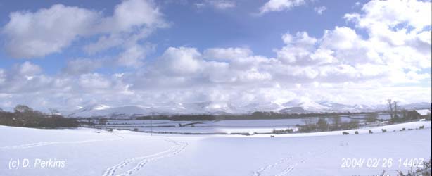 26th: There was heavy snowfall during the morning. At 1131 GMT this was how the weather station looked
 ![]() . When it had stopped snowing the automatic raingauge was checked to see that everything was running properly. A heater inside keeps the funnel warm melting the snow on contact
. When it had stopped snowing the automatic raingauge was checked to see that everything was running properly. A heater inside keeps the funnel warm melting the snow on contact ![]() .
.
The snow was sufficient to bring traffic to a halt, this car went nowhere this day![]() . The garden was covered with about 13 cm of snow
. The garden was covered with about 13 cm of snow ![]() . This was the scene looking across snow covered fields towards the Nant Ffrancon Pass
. This was the scene looking across snow covered fields towards the Nant Ffrancon Pass ![]() .
.
There was even snow down to sea level at Malltraeth, Anglesey
![]() . The view is of the Cefni Estuary near high tide.
. The view is of the Cefni Estuary near high tide.
27th: ![]() Snow showers driven by a NE'ly wind (left to right) move across the Snowdonia Mountains during the afternoon. From the left Carneddau, Nant Ffrancon Pass with the summit of Tryfan, Mynydd Perfedd and Elidir Fach with Glyders behind, Llanberis Pass and Snowdon on the right.
Snow showers driven by a NE'ly wind (left to right) move across the Snowdonia Mountains during the afternoon. From the left Carneddau, Nant Ffrancon Pass with the summit of Tryfan, Mynydd Perfedd and Elidir Fach with Glyders behind, Llanberis Pass and Snowdon on the right.
28th: Snow in the Llanberis Pass. ![]() View is looking SE across Llyn Padarn.
View is looking SE across Llyn Padarn.
Mountain snow. Yr Wyddfa summit (3560 ft) just obscured in cumulus cloud. ![]() Lliwedd is on the left, Crib Goch on the right. While this
Lliwedd is on the left, Crib Goch on the right. While this ![]() looks across towards the road from Pen-y-pass, on the left, towards Pen-y-Gwryd on the right .
looks across towards the road from Pen-y-pass, on the left, towards Pen-y-Gwryd on the right .
This wider view of Snowdon is across the Gwynant valley near Gwastadannas on the Beddgelert road ![]() . Cwm Dyli hydroelectric power station lies in the bottom of the valley
. Cwm Dyli hydroelectric power station lies in the bottom of the valley ![]() It was built by the North Wales Power and Traction Company in 1905. A small dam was built at the terminal moraine across Llyn Llydaw (at 1400 ft) and piped to the power station in the bottom of the valley over 1000 ft below. The catchment area for rainwater and melted snow is over 4 sq. kilometres. It is one of the oldest power stations running in the UK today, and still generating electricity for the National Grid. It precedes both the Snowdon National Nature Reserve and the National Park. Originally with 2 turbines and generators supplied by 2 water pipes it now operates a single generator, powered by a Francis turbine, using 1 larger diameter pipe. At full output the station produces 10 MW of electricity and uses 3,500 litres of water per second. The water flows out into the Afon Glaslyn, that feeds Llyn Gwynant seen in the photograph looking southwest down the valley, thence to Llyn Dinas and on to Beddgelert
It was built by the North Wales Power and Traction Company in 1905. A small dam was built at the terminal moraine across Llyn Llydaw (at 1400 ft) and piped to the power station in the bottom of the valley over 1000 ft below. The catchment area for rainwater and melted snow is over 4 sq. kilometres. It is one of the oldest power stations running in the UK today, and still generating electricity for the National Grid. It precedes both the Snowdon National Nature Reserve and the National Park. Originally with 2 turbines and generators supplied by 2 water pipes it now operates a single generator, powered by a Francis turbine, using 1 larger diameter pipe. At full output the station produces 10 MW of electricity and uses 3,500 litres of water per second. The water flows out into the Afon Glaslyn, that feeds Llyn Gwynant seen in the photograph looking southwest down the valley, thence to Llyn Dinas and on to Beddgelert ![]() .
.
March 2004
1st: St David's Day daffodils in flower in the garden undamaged after the snow ![]() . A purple-coloured after-sunset sky with smoke haze
. A purple-coloured after-sunset sky with smoke haze ![]() .
.
7th: Cumulus clouds persisted over Snowdonia during the day ![]() . The is view SE across the Cefni Estuary. In contrast there were just a few fair-weather cumulus clouds over Anglesey. This view is looking NW with South Stack just visible on the horizon centre left, while Holyhead Mountain may just be seen centre right between 2 trees
. The is view SE across the Cefni Estuary. In contrast there were just a few fair-weather cumulus clouds over Anglesey. This view is looking NW with South Stack just visible on the horizon centre left, while Holyhead Mountain may just be seen centre right between 2 trees ![]() .
.
12th: ![]() A fresh sprinkling of snow at 600 ft on the Carneddau Mountains.
A fresh sprinkling of snow at 600 ft on the Carneddau Mountains.
17th: ![]() The complete series of photographs taken at the weather station, during the Great UK Weather Watch Day, illustrating the changing weather through the day.
The complete series of photographs taken at the weather station, during the Great UK Weather Watch Day, illustrating the changing weather through the day.
19th: Uprooted tree on field looking W from the weather station ![]() . A towering cumulus cloud close to the weather station, looking E
. A towering cumulus cloud close to the weather station, looking E ![]() .
.
20th: Approach of the high tide: The storm at Malltraeth ![]() . Water in the River Cefni backed up at the high tide, note the small headroom left under the bridge
. Water in the River Cefni backed up at the high tide, note the small headroom left under the bridge ![]() : The storm at Malltraeth. But the tide luckily was not high enough to cause any flooding on this occasion
: The storm at Malltraeth. But the tide luckily was not high enough to cause any flooding on this occasion ![]() .
.
23rd: Convective clouds developed through the day and a cumulonimbus gave rain early in Caernarfon in the afternoon. Later in the afternoon a cumulonimbus was spotted to the south of the weather station ![]() .
.
25th: Orographic cloud S of the Menai Strait during the afternoon. Looking NE from Beaumaris pier towards Llandudno, taken 8 minutes before the satellite image ![]() . Looking SSW from Beaumaris pier
. Looking SSW from Beaumaris pier ![]() .
.
31st: ![]() There was medium level altostratus cloud and a milky sky in the afternoon. Looking W from the weather station.
There was medium level altostratus cloud and a milky sky in the afternoon. Looking W from the weather station.
April 2004
2nd: It was a warm sunny day, this peacock butterfly was caught feeding on primrose flowers soon after emerging from hibernation in a nearby wood pile ![]() .
.
12th: Ploughing being done near the weather station ![]() . During the afternoon the air cleared and there was a clear view across to the Carneddau Mountains
. During the afternoon the air cleared and there was a clear view across to the Carneddau Mountains ![]() .
.
16th: Edge of frontal cloud moving S was forecast to return later on but kept stationary through the day ![]() . Clearer sky to the W with some cumulus clouds developing over the Irish Sea
. Clearer sky to the W with some cumulus clouds developing over the Irish Sea ![]() . During the afternoon convergent convective cloud was seen to the W
. During the afternoon convergent convective cloud was seen to the W
![]() . To the S the front remained stationary over the Menai Strait
. To the S the front remained stationary over the Menai Strait ![]() . By evening the front was still there to the S with cirrus clouds developed overhead
. By evening the front was still there to the S with cirrus clouds developed overhead ![]() .
.
22nd: Cumulus cloud over the allotments at Beaumaris ![]() . Beaumaris on a sunny day. The Castle wall is on the left, the White Lion Hotel ahead across Castle Street
. Beaumaris on a sunny day. The Castle wall is on the left, the White Lion Hotel ahead across Castle Street ![]() .
.
![]() A line of stratocumulus clouds over Snowdonia in the afternoon. Note the trees showing up green with increasing leaf emergence.
A line of stratocumulus clouds over Snowdonia in the afternoon. Note the trees showing up green with increasing leaf emergence.
24th: ![]() View looking S from the weather station showing (over the trees) sea fog in the Menai Strait. Under the cloud mountaintops can be seen above the fog.
View looking S from the weather station showing (over the trees) sea fog in the Menai Strait. Under the cloud mountaintops can be seen above the fog.
![]() Under low cloud sea fog was blowing from the Cefni Estuary over the Cob at Malltraeth.
Under low cloud sea fog was blowing from the Cefni Estuary over the Cob at Malltraeth.
May 2004
7th: ![]() Cumulonimbus cloud over Snowdonia on 7 May 2004. Looking S from the weather station.
Cumulonimbus cloud over Snowdonia on 7 May 2004. Looking S from the weather station.
![]() Looking W from the weather station the hawthorn hedge and broadleaved trees with light- green foliage were still expanding.
Looking W from the weather station the hawthorn hedge and broadleaved trees with light- green foliage were still expanding.
12th: ![]() A misty morning on the Menai Strait at Beaumaris with the mountains obscured. Boats floating on unusually calm water with the tide receding.
A misty morning on the Menai Strait at Beaumaris with the mountains obscured. Boats floating on unusually calm water with the tide receding.
14th: ![]() A mostly sunny and warm afternoon, with apple trees blossoming at Brynsiencyn on Anglesey. Snowdonia, with persistent stratocumulus clouds, across the Menai Strait hidden by trees..
A mostly sunny and warm afternoon, with apple trees blossoming at Brynsiencyn on Anglesey. Snowdonia, with persistent stratocumulus clouds, across the Menai Strait hidden by trees..
15th: ![]() Sunny with cumulus clouds at Porth Eilean (Point Lynas), at low water.
Sunny with cumulus clouds at Porth Eilean (Point Lynas), at low water.
17th: ![]() This view was taken at Tywyn Aberffraw . The view is looking N (roofs of houses in Aberffraw village just visible in left of image). The cloud is a front moving down from the N that arrived later in the afternoon.
This view was taken at Tywyn Aberffraw . The view is looking N (roofs of houses in Aberffraw village just visible in left of image). The cloud is a front moving down from the N that arrived later in the afternoon.
18th: A sunny afternoon at Point Lynas ![]() . Cloud on horizon to the N is the approaching cold front. The lighthouse, along with other lights around the coast of Britain, is now automatically operated. The buildings that used to house the keepers have been sold. The photograph shows the light gallery and above a radar, weather instruments, radio and other equipment. The inverted 'lamp shade' is a device used for monitoring any radioactive particles in the air, one of several on the island, part of the environmental monitoring done in relation to the Nuclear Power Station at Wylfa, 13 km west.
. Cloud on horizon to the N is the approaching cold front. The lighthouse, along with other lights around the coast of Britain, is now automatically operated. The buildings that used to house the keepers have been sold. The photograph shows the light gallery and above a radar, weather instruments, radio and other equipment. The inverted 'lamp shade' is a device used for monitoring any radioactive particles in the air, one of several on the island, part of the environmental monitoring done in relation to the Nuclear Power Station at Wylfa, 13 km west. ![]() .
.
20th: ![]() Banded cirrostratus, cirrus and small cumulus clouds. Looking N across the Menai Strait to Anglesey from Caernarfon in the afternoon.
Banded cirrostratus, cirrus and small cumulus clouds. Looking N across the Menai Strait to Anglesey from Caernarfon in the afternoon.
25th: There was an almost clear sky over Castle Street in Beaumaris in the morning ![]() . The flags had been put up for the Music Festival being held during the week. Looking towards Gallows Point it is cloudier with cumulus clouds over the Menai Strait and Snowdonia. Moored boats, that had been resting on the mud, were beginning to lift off on a rising tide
. The flags had been put up for the Music Festival being held during the week. Looking towards Gallows Point it is cloudier with cumulus clouds over the Menai Strait and Snowdonia. Moored boats, that had been resting on the mud, were beginning to lift off on a rising tide ![]() .
.
Other weather photograph galleries ![]() 2001;
2001;
![]() 2002; and
2002; and
![]() 2003;
2003;
Plants, Flowers and Ecology of Anglesey ![]() 2002-03; and
2002-03; and ![]() 2004
2004
Now you have seen the photographs read about the weather on the day in my diary ![]() 2004;
2004; ![]() Latest diary
Latest diary
Most photographs on this page were taken with a Casio QV-3000EX/lr digital camera, some on film with a Canon EOS 3000, and are watermarked for copyright protection. For use of material in publication please contact the author.
|
These pages are designed and written by Donald Perkins Photographs and text are copyright ©: 2004. All rights reserved.Page dated 22 May 2004, but new photos added from time to time. http://www.llansadwrn-wx.co.uk
|